
Size of this PNG preview of this SVG file:
601 × 599 pixels. Other resolutions:
241 × 240 pixels |
481 × 480 pixels |
770 × 768 pixels |
1,027 × 1,024 pixels |
2,054 × 2,048 pixels |
7,342 × 7,321 pixels.
Original file (SVG file, nominally 7,342 × 7,321 pixels, file size: 320 KB)
| This is a file from the
Wikimedia Commons. Information from its
description page there is shown below. Commons is a freely licensed media file repository. You can help. |
Summary
| Description |
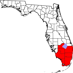
English: Map showing the county warning area for the National Weather Service office in Miami, Florida. |
| Date | |
| Source | Own work, derivative work of File:Map of Florida highlighting Hillsborough County.svg by User:David Benbennick |
| Author | Ks0stm |
Licensing
| I, the copyright holder of this work, release this work into the
public domain. This applies worldwide. In some countries this may not be legally possible; if so: I grant anyone the right to use this work for any purpose, without any conditions, unless such conditions are required by law. |
File history
Click on a date/time to view the file as it appeared at that time.
| Date/Time | Thumbnail | Dimensions | User | Comment | |
|---|---|---|---|---|---|
| current | 13:17, 6 July 2024 |
| 7,342 × 7,321 (320 KB) | Nux | fix rendering (remove clipping), uniform colors |
| 00:39, 22 November 2010 |
 | 7,342 × 7,321 (331 KB) | Ks0stm | {{Information |Description={{en|1=Map showing the county warning area for the National Weather Service office in Miami, Florida.}} |Source={{own}}, derivative work of File:Map of Florida highlighting Hillsborough County.svg by [[User:David Benbennick |
File usage
The following pages on the English Wikipedia use this file (pages on other projects are not listed):
Metadata
Size of this PNG preview of this SVG file:
601 × 599 pixels. Other resolutions:
241 × 240 pixels |
481 × 480 pixels |
770 × 768 pixels |
1,027 × 1,024 pixels |
2,054 × 2,048 pixels |
7,342 × 7,321 pixels.
Original file (SVG file, nominally 7,342 × 7,321 pixels, file size: 320 KB)
| This is a file from the
Wikimedia Commons. Information from its
description page there is shown below. Commons is a freely licensed media file repository. You can help. |
Summary
| Description |
English: Map showing the county warning area for the National Weather Service office in Miami, Florida. |
| Date | |
| Source | Own work, derivative work of File:Map of Florida highlighting Hillsborough County.svg by User:David Benbennick |
| Author | Ks0stm |
Licensing
| I, the copyright holder of this work, release this work into the
public domain. This applies worldwide. In some countries this may not be legally possible; if so: I grant anyone the right to use this work for any purpose, without any conditions, unless such conditions are required by law. |
File history
Click on a date/time to view the file as it appeared at that time.
| Date/Time | Thumbnail | Dimensions | User | Comment | |
|---|---|---|---|---|---|
| current | 13:17, 6 July 2024 |
| 7,342 × 7,321 (320 KB) | Nux | fix rendering (remove clipping), uniform colors |
| 00:39, 22 November 2010 |
| 7,342 × 7,321 (331 KB) | Ks0stm | {{Information |Description={{en|1=Map showing the county warning area for the National Weather Service office in Miami, Florida.}} |Source={{own}}, derivative work of File:Map of Florida highlighting Hillsborough County.svg by [[User:David Benbennick |
File usage
The following pages on the English Wikipedia use this file (pages on other projects are not listed):