
Size of this PNG preview of this SVG file:
800 × 406 pixels. Other resolutions:
320 × 162 pixels |
640 × 325 pixels |
1,024 × 520 pixels |
1,280 × 650 pixels |
2,560 × 1,300 pixels |
2,754 × 1,398 pixels.
Original file (SVG file, nominally 2,754 × 1,398 pixels, file size: 1.05 MB)
| This is a file from the
Wikimedia Commons. Information from its
description page there is shown below. Commons is a freely licensed media file repository. You can help. |

Summary
| Description |
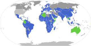
English: Parties to the
w:Nagoya protocol to the
w:Biological Diversity Convention
Parties
Only signed, but not ratified
non signatory, but Biological Diversity Convention party
non signatory, non-Biological Diversity Convention party Français : Participation au protocole de Nagoya
Partie au protocole
Signé mais pas ratifié
Non-signataire et partie à la Convention sur la diversité biologique
Non-signataire et non partie à la Convention sur la diversité biologique |
| Date | |
| Source | Own work |
| Author | L.tak |

|
This file may be updated to reflect new information. If you wish to use a specific version of the file without new updates being mirrored, please upload the required version as a separate file. |
Licensing
I, the copyright holder of this work, hereby publish it under the following license:
This file is licensed under the
Creative Commons
Attribution-Share Alike 4.0 International license.
- You are free:
- to share – to copy, distribute and transmit the work
- to remix – to adapt the work
- Under the following conditions:
- attribution – You must give appropriate credit, provide a link to the license, and indicate if changes were made. You may do so in any reasonable manner, but not in any way that suggests the licensor endorses you or your use.
- share alike – If you remix, transform, or build upon the material, you must distribute your contributions under the same or compatible license as the original.
File history
Click on a date/time to view the file as it appeared at that time.
| Date/Time | Thumbnail | Dimensions | User | Comment | |
|---|---|---|---|---|---|
| current | 00:40, 14 November 2022 |
| 2,754 × 1,398 (1.05 MB) | Louperivois | Bahamas, Bahrain, Morocco, Nigeria, St. Lucia, Ukraine |
| 22:19, 27 September 2021 |
 | 2,754 × 1,398 (1.05 MB) | Louperivois | Kiribati, Brazil, Tunisia | |
| 21:36, 14 February 2021 |
 | 2,754 × 1,398 (1.05 MB) | Louperivois | Latest version of BlankMap-World.svg. Fix Crimea and various territories, add Turkmenistan and Montenegro. | |
| 21:23, 26 January 2021 |
 | 512 × 260 (2.07 MB) | Novikoffav | The Crimea Peninsula in the last edition of the map was incorrectly indicated as Russian territory. Here this bug is fixed. | |
| 18:18, 23 July 2020 |
 | 2,754 × 1,398 (1.05 MB) | Louperivois | Korea,Eritrea,Estonia,Ghana,Greece,Maldives,Nepal,Nicaragua,Oman,Romania,Saudi Arabia,Solomon Islands,Tonga | |
| 01:30, 9 November 2018 |
 | 2,560 × 1,314 (1.05 MB) | MlaplanteD | Major updates and corrections. | |
| 13:14, 13 June 2016 |
 | 863 × 443 (1.54 MB) | L.tak | +cn and de (ao) | |
| 14:04, 27 February 2016 |
 | 863 × 443 (1.54 MB) | L.tak | update | |
| 13:41, 16 May 2015 |
 | 863 × 443 (1.54 MB) | L.tak | User created page with UploadWizard |
File usage
The following pages on the English Wikipedia use this file (pages on other projects are not listed):
Global file usage
The following other wikis use this file:
- Usage on ar.wikipedia.org
- Usage on as.wikipedia.org
- Usage on cs.wikipedia.org
- Usage on cy.wikipedia.org
- Usage on de.wikipedia.org
- Usage on es.wikipedia.org
- Usage on et.wikipedia.org
- Usage on fa.wikipedia.org
- Usage on fr.wikipedia.org
- Usage on id.wikipedia.org
- Usage on it.wikipedia.org
- Usage on ka.wikipedia.org
- Usage on ml.wikipedia.org
- Usage on ms.wikipedia.org
- Usage on no.wikipedia.org
- Usage on pt.wikipedia.org
- Usage on ro.wikipedia.org
- Usage on th.wikipedia.org
- Usage on www.wikidata.org
- Usage on zh.wikipedia.org
Metadata
Size of this PNG preview of this SVG file:
800 × 406 pixels. Other resolutions:
320 × 162 pixels |
640 × 325 pixels |
1,024 × 520 pixels |
1,280 × 650 pixels |
2,560 × 1,300 pixels |
2,754 × 1,398 pixels.
Original file (SVG file, nominally 2,754 × 1,398 pixels, file size: 1.05 MB)
| This is a file from the
Wikimedia Commons. Information from its
description page there is shown below. Commons is a freely licensed media file repository. You can help. |
Summary
| Description |
English: Parties to the
w:Nagoya protocol to the
w:Biological Diversity Convention
Parties
Only signed, but not ratified
non signatory, but Biological Diversity Convention party
non signatory, non-Biological Diversity Convention party Français : Participation au protocole de Nagoya
Partie au protocole
Signé mais pas ratifié
Non-signataire et partie à la Convention sur la diversité biologique
Non-signataire et non partie à la Convention sur la diversité biologique |
| Date | |
| Source | Own work |
| Author | L.tak |
|
|
This file may be updated to reflect new information. If you wish to use a specific version of the file without new updates being mirrored, please upload the required version as a separate file. |
Licensing
I, the copyright holder of this work, hereby publish it under the following license:
This file is licensed under the
Creative Commons
Attribution-Share Alike 4.0 International license.
- You are free:
- to share – to copy, distribute and transmit the work
- to remix – to adapt the work
- Under the following conditions:
- attribution – You must give appropriate credit, provide a link to the license, and indicate if changes were made. You may do so in any reasonable manner, but not in any way that suggests the licensor endorses you or your use.
- share alike – If you remix, transform, or build upon the material, you must distribute your contributions under the same or compatible license as the original.
File history
Click on a date/time to view the file as it appeared at that time.
| Date/Time | Thumbnail | Dimensions | User | Comment | |
|---|---|---|---|---|---|
| current | 00:40, 14 November 2022 |
| 2,754 × 1,398 (1.05 MB) | Louperivois | Bahamas, Bahrain, Morocco, Nigeria, St. Lucia, Ukraine |
| 22:19, 27 September 2021 |
| 2,754 × 1,398 (1.05 MB) | Louperivois | Kiribati, Brazil, Tunisia | |
| 21:36, 14 February 2021 |
| 2,754 × 1,398 (1.05 MB) | Louperivois | Latest version of BlankMap-World.svg. Fix Crimea and various territories, add Turkmenistan and Montenegro. | |
| 21:23, 26 January 2021 |
| 512 × 260 (2.07 MB) | Novikoffav | The Crimea Peninsula in the last edition of the map was incorrectly indicated as Russian territory. Here this bug is fixed. | |
| 18:18, 23 July 2020 |
| 2,754 × 1,398 (1.05 MB) | Louperivois | Korea,Eritrea,Estonia,Ghana,Greece,Maldives,Nepal,Nicaragua,Oman,Romania,Saudi Arabia,Solomon Islands,Tonga | |
| 01:30, 9 November 2018 |
| 2,560 × 1,314 (1.05 MB) | MlaplanteD | Major updates and corrections. | |
| 13:14, 13 June 2016 |
| 863 × 443 (1.54 MB) | L.tak | +cn and de (ao) | |
| 14:04, 27 February 2016 |
| 863 × 443 (1.54 MB) | L.tak | update | |
| 13:41, 16 May 2015 |
| 863 × 443 (1.54 MB) | L.tak | User created page with UploadWizard |
File usage
The following pages on the English Wikipedia use this file (pages on other projects are not listed):
Global file usage
The following other wikis use this file:
- Usage on ar.wikipedia.org
- Usage on as.wikipedia.org
- Usage on cs.wikipedia.org
- Usage on cy.wikipedia.org
- Usage on de.wikipedia.org
- Usage on es.wikipedia.org
- Usage on et.wikipedia.org
- Usage on fa.wikipedia.org
- Usage on fr.wikipedia.org
- Usage on id.wikipedia.org
- Usage on it.wikipedia.org
- Usage on ka.wikipedia.org
- Usage on ml.wikipedia.org
- Usage on ms.wikipedia.org
- Usage on no.wikipedia.org
- Usage on pt.wikipedia.org
- Usage on ro.wikipedia.org
- Usage on th.wikipedia.org
- Usage on www.wikidata.org
- Usage on zh.wikipedia.org