
Size of this PNG preview of this SVG file:
512 × 304 pixels. Other resolutions:
320 × 190 pixels |
640 × 380 pixels |
1,024 × 608 pixels |
1,280 × 760 pixels |
2,560 × 1,520 pixels.
Original file (SVG file, nominally 512 × 304 pixels, file size: 288 KB)
| This is a file from the
Wikimedia Commons. Information from its
description page there is shown below. Commons is a freely licensed media file repository. You can help. |
Summary
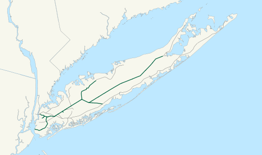
| Description | Map of New York and Atlantic Railway freight operations as of April 2017, in green. Lines in gray are LIRR trackage with no freight operations. |
| Date | (UTC) |
| Source |
This file was derived from:
LIRR map.svg:
|
| Author |
|
Licensing
I, the copyright holder of this work, hereby publish it under the following license:
| I, the copyright holder of this work, release this work into the
public domain. This applies worldwide. In some countries this may not be legally possible; if so: I grant anyone the right to use this work for any purpose, without any conditions, unless such conditions are required by law. |
Original upload log
This image is a derivative work of the following images:
-
File:LIRR_map.svg licensed with PD-self
- 2007-01-23T05:11:48Z NE2 1152x684 (597443 Bytes) Changed the orange.
- 2007-01-23T05:05:08Z NE2 1152x684 (597443 Bytes) Made the black grayer.
- 2007-01-23T05:03:12Z NE2 1152x684 (597443 Bytes) Added a few features.
- 2006-12-13T10:34:59Z NE2 1152x684 (529065 Bytes) This is a map of the rail network currentl[y owned by the Long Island Rail Road. Orange lines are freight-only, and are operated by the New York and Atlantic Railway. The following GIS data was used: *[http://www.bts.gov/pub
Uploaded with derivativeFX
File history
Click on a date/time to view the file as it appeared at that time.
| Date/Time | Thumbnail | Dimensions | User | Comment | |
|---|---|---|---|---|---|
| current | 22:50, 9 April 2017 |
| 512 × 304 (288 KB) | Train2104 | Remove border |
| 22:48, 9 April 2017 |
 | 512 × 304 (347 KB) | Train2104 | == {{int:filedesc}} == {{Information |Description=Map of New York and Atlantic Railway freight operations as of April 2017, in green. Lines in gray are LIRR trackage with no freight operations. |Source={{Derived from|LIRR_map.svg|display=50}} |Date=201... |
File usage
The following pages on the English Wikipedia use this file (pages on other projects are not listed):
Global file usage
The following other wikis use this file:
- Usage on de.wikipedia.org
- Usage on www.wikidata.org
Metadata
Size of this PNG preview of this SVG file:
512 × 304 pixels. Other resolutions:
320 × 190 pixels |
640 × 380 pixels |
1,024 × 608 pixels |
1,280 × 760 pixels |
2,560 × 1,520 pixels.
Original file (SVG file, nominally 512 × 304 pixels, file size: 288 KB)
| This is a file from the
Wikimedia Commons. Information from its
description page there is shown below. Commons is a freely licensed media file repository. You can help. |
Summary
| Description | Map of New York and Atlantic Railway freight operations as of April 2017, in green. Lines in gray are LIRR trackage with no freight operations. |
| Date | (UTC) |
| Source |
This file was derived from:
LIRR map.svg:
|
| Author |
|
Licensing
I, the copyright holder of this work, hereby publish it under the following license:
| I, the copyright holder of this work, release this work into the
public domain. This applies worldwide. In some countries this may not be legally possible; if so: I grant anyone the right to use this work for any purpose, without any conditions, unless such conditions are required by law. |
Original upload log
This image is a derivative work of the following images:
-
File:LIRR_map.svg licensed with PD-self
- 2007-01-23T05:11:48Z NE2 1152x684 (597443 Bytes) Changed the orange.
- 2007-01-23T05:05:08Z NE2 1152x684 (597443 Bytes) Made the black grayer.
- 2007-01-23T05:03:12Z NE2 1152x684 (597443 Bytes) Added a few features.
- 2006-12-13T10:34:59Z NE2 1152x684 (529065 Bytes) This is a map of the rail network currentl[y owned by the Long Island Rail Road. Orange lines are freight-only, and are operated by the New York and Atlantic Railway. The following GIS data was used: *[http://www.bts.gov/pub
Uploaded with derivativeFX
File history
Click on a date/time to view the file as it appeared at that time.
| Date/Time | Thumbnail | Dimensions | User | Comment | |
|---|---|---|---|---|---|
| current | 22:50, 9 April 2017 |
| 512 × 304 (288 KB) | Train2104 | Remove border |
| 22:48, 9 April 2017 |
| 512 × 304 (347 KB) | Train2104 | == {{int:filedesc}} == {{Information |Description=Map of New York and Atlantic Railway freight operations as of April 2017, in green. Lines in gray are LIRR trackage with no freight operations. |Source={{Derived from|LIRR_map.svg|display=50}} |Date=201... |
File usage
The following pages on the English Wikipedia use this file (pages on other projects are not listed):
Global file usage
The following other wikis use this file:
- Usage on de.wikipedia.org
- Usage on www.wikidata.org