
Original file (4,500 × 3,375 pixels, file size: 3.2 MB, MIME type: image/jpeg)
| This is a file from the
Wikimedia Commons. Information from its
description page there is shown below. Commons is a freely licensed media file repository. You can help. |
Summary
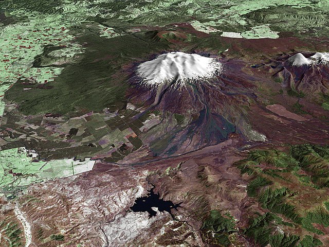
| Description | Composite image of Mount Ruapehu, with Hauhungatahi visible beyond. North Island, New Zealand. Image is composed of satellite imagery from Landsat and topography data from the Shuttle Radar Topography Mission aboard the Space Shuttle Endeavour. |
| Date | |
| Source | http://earthobservatory.nasa.gov/Newsroom/NewImages/images.php3?img_id=16522 |
| Author |
Landsat data provided courtesy of the University of Maryland Global Land Cover Facility Landsat processing by Laura Rocchio, Landsat Project Science Office SRTM 3-arcsecond elevation data courtesy of SRTM Team NASA/JPL/NIMA Visualization created by Earth Observatory staff. |
| Permission ( Reusing this file) |
Public domain |
Licensing
| This file is in the public domain in the United States because it was solely created by NASA. NASA copyright policy states that "NASA material is not protected by copyright unless noted". (See Template:PD-USGov, NASA copyright policy page or JPL Image Use Policy.) | ||
 |
Warnings:
|
File history
Click on a date/time to view the file as it appeared at that time.
| Date/Time | Thumbnail | Dimensions | User | Comment | |
|---|---|---|---|---|---|
| current | 15:17, 28 April 2010 |
| 4,500 × 3,375 (3.2 MB) | Originalwana | higher res |
| 20:56, 25 May 2006 |
 | 1,800 × 1,800 (819 KB) | Holly Cheng | {{Information | Description=Composite image of w:Mount Ruapehu, North Island, New Zealand. Image is composed of satellite imagery from Landsat and topography data from the Shuttle Radar Topography Mission aboard the Space Shuttle Endeavour. | Source=h |
File usage
Global file usage
The following other wikis use this file:
- Usage on ar.wikipedia.org
- Usage on ceb.wikipedia.org
- Usage on de.wikipedia.org
- Usage on en.wikiversity.org
- Usage on gl.wikipedia.org
- Usage on hr.wikipedia.org
- Usage on hy.wikipedia.org
- Usage on it.wikipedia.org
- Usage on ja.wikipedia.org
- Usage on ko.wikipedia.org
- Usage on mk.wikipedia.org
- Usage on nl.wikipedia.org
- Usage on nn.wikipedia.org
- Usage on pl.wikipedia.org
- Usage on sh.wikipedia.org
- Usage on sl.wikipedia.org
- Usage on sv.wikipedia.org
- Usage on zh.wikipedia.org
Metadata
Original file (4,500 × 3,375 pixels, file size: 3.2 MB, MIME type: image/jpeg)
| This is a file from the
Wikimedia Commons. Information from its
description page there is shown below. Commons is a freely licensed media file repository. You can help. |
Summary
| Description | Composite image of Mount Ruapehu, with Hauhungatahi visible beyond. North Island, New Zealand. Image is composed of satellite imagery from Landsat and topography data from the Shuttle Radar Topography Mission aboard the Space Shuttle Endeavour. |
| Date | |
| Source | http://earthobservatory.nasa.gov/Newsroom/NewImages/images.php3?img_id=16522 |
| Author |
Landsat data provided courtesy of the University of Maryland Global Land Cover Facility Landsat processing by Laura Rocchio, Landsat Project Science Office SRTM 3-arcsecond elevation data courtesy of SRTM Team NASA/JPL/NIMA Visualization created by Earth Observatory staff. |
| Permission ( Reusing this file) |
Public domain |
Licensing
| This file is in the public domain in the United States because it was solely created by NASA. NASA copyright policy states that "NASA material is not protected by copyright unless noted". (See Template:PD-USGov, NASA copyright policy page or JPL Image Use Policy.) | ||
|
Warnings:
|
File history
Click on a date/time to view the file as it appeared at that time.
| Date/Time | Thumbnail | Dimensions | User | Comment | |
|---|---|---|---|---|---|
| current | 15:17, 28 April 2010 |
| 4,500 × 3,375 (3.2 MB) | Originalwana | higher res |
| 20:56, 25 May 2006 |
| 1,800 × 1,800 (819 KB) | Holly Cheng | {{Information | Description=Composite image of w:Mount Ruapehu, North Island, New Zealand. Image is composed of satellite imagery from Landsat and topography data from the Shuttle Radar Topography Mission aboard the Space Shuttle Endeavour. | Source=h |
File usage
Global file usage
The following other wikis use this file:
- Usage on ar.wikipedia.org
- Usage on ceb.wikipedia.org
- Usage on de.wikipedia.org
- Usage on en.wikiversity.org
- Usage on gl.wikipedia.org
- Usage on hr.wikipedia.org
- Usage on hy.wikipedia.org
- Usage on it.wikipedia.org
- Usage on ja.wikipedia.org
- Usage on ko.wikipedia.org
- Usage on mk.wikipedia.org
- Usage on nl.wikipedia.org
- Usage on nn.wikipedia.org
- Usage on pl.wikipedia.org
- Usage on sh.wikipedia.org
- Usage on sl.wikipedia.org
- Usage on sv.wikipedia.org
- Usage on zh.wikipedia.org