Photos • Location


No higher resolution available.
Monsal_Dale_-_geograph.org.uk_-_1589877.jpg (640 × 480 pixels, file size: 125 KB, MIME type: image/jpeg)
| This is a file from the
Wikimedia Commons. Information from its
description page there is shown below. Commons is a freely licensed media file repository. You can help. |
Summary
| Description |
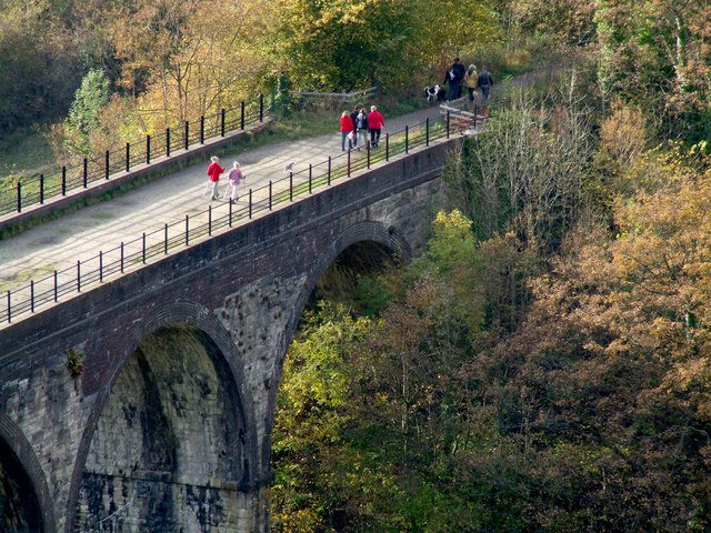
English: Monsal Dale The former Midland Railway's viaduct. The walkers are heading in the Buxton direction and will soon reach a tunnel, which is closed.
I walked this viaduct just after the track was lifted and went through the tunnel, under Monsal Head, in the direction of Matlock. I was lucky not to fall down a shaft, which I stumbled upon in the dark. |
| Date | |
| Source | From geograph.org.uk |
| Author | Dave Hitchborne |
| Attribution ( required by the license) | Dave Hitchborne / Monsal Dale / |
| Camera location | | View this and other nearby images on: OpenStreetMap |
|
|---|
_heading:292.00&language=en)
| Object location | | View this and other nearby images on: OpenStreetMap |
|
|---|
_heading:292.00&language=en)
Licensing

|
This image was taken from the
Geograph project collection. See
this photograph's page on the Geograph website for the photographer's contact details. The copyright on this image is owned by Dave Hitchborne and is licensed for reuse under the
Creative Commons Attribution-ShareAlike 2.0 license.
|
This file is licensed under the
Creative Commons
Attribution-Share Alike 2.0 Generic license.
Attribution: Dave Hitchborne
- You are free:
- to share – to copy, distribute and transmit the work
- to remix – to adapt the work
- Under the following conditions:
- attribution – You must give appropriate credit, provide a link to the license, and indicate if changes were made. You may do so in any reasonable manner, but not in any way that suggests the licensor endorses you or your use.
- share alike – If you remix, transform, or build upon the material, you must distribute your contributions under the same or compatible license as the original.
File history
Click on a date/time to view the file as it appeared at that time.
| Date/Time | Thumbnail | Dimensions | User | Comment | |
|---|---|---|---|---|---|
| current | 00:21, 4 March 2011 |
| 640 × 480 (125 KB) | GeographBot | == {{int:filedesc}} == {{Information |description={{en|1=Monsal Dale The former Midland Railway's viaduct. The walkers are heading in the Buxton direction and will soon reach a tunnel, which is closed. I walked this viaduct just after the track was lifte |
File usage
The following pages on the English Wikipedia use this file (pages on other projects are not listed):
Global file usage
The following other wikis use this file:
- Usage on www.wikidata.org
Metadata
No higher resolution available.
Monsal_Dale_-_geograph.org.uk_-_1589877.jpg (640 × 480 pixels, file size: 125 KB, MIME type: image/jpeg)
| This is a file from the
Wikimedia Commons. Information from its
description page there is shown below. Commons is a freely licensed media file repository. You can help. |
Summary
| Description |
English: Monsal Dale The former Midland Railway's viaduct. The walkers are heading in the Buxton direction and will soon reach a tunnel, which is closed.
I walked this viaduct just after the track was lifted and went through the tunnel, under Monsal Head, in the direction of Matlock. I was lucky not to fall down a shaft, which I stumbled upon in the dark. |
| Date | |
| Source | From geograph.org.uk |
| Author | Dave Hitchborne |
| Attribution ( required by the license) | Dave Hitchborne / Monsal Dale / |
| Camera location | | View this and other nearby images on: OpenStreetMap |
|
|---|
| Object location | | View this and other nearby images on: OpenStreetMap |
|
|---|
Licensing
|
|
This image was taken from the
Geograph project collection. See
this photograph's page on the Geograph website for the photographer's contact details. The copyright on this image is owned by Dave Hitchborne and is licensed for reuse under the
Creative Commons Attribution-ShareAlike 2.0 license.
|
This file is licensed under the
Creative Commons
Attribution-Share Alike 2.0 Generic license.
Attribution: Dave Hitchborne
- You are free:
- to share – to copy, distribute and transmit the work
- to remix – to adapt the work
- Under the following conditions:
- attribution – You must give appropriate credit, provide a link to the license, and indicate if changes were made. You may do so in any reasonable manner, but not in any way that suggests the licensor endorses you or your use.
- share alike – If you remix, transform, or build upon the material, you must distribute your contributions under the same or compatible license as the original.
File history
Click on a date/time to view the file as it appeared at that time.
| Date/Time | Thumbnail | Dimensions | User | Comment | |
|---|---|---|---|---|---|
| current | 00:21, 4 March 2011 |
| 640 × 480 (125 KB) | GeographBot | == {{int:filedesc}} == {{Information |description={{en|1=Monsal Dale The former Midland Railway's viaduct. The walkers are heading in the Buxton direction and will soon reach a tunnel, which is closed. I walked this viaduct just after the track was lifte |
File usage
The following pages on the English Wikipedia use this file (pages on other projects are not listed):
Global file usage
The following other wikis use this file:
- Usage on www.wikidata.org