Size of this preview:
511 × 599 pixels. Other resolutions:
205 × 240 pixels |
409 × 480 pixels |
1,000 × 1,172 pixels.
Original file (1,000 × 1,172 pixels, file size: 544 KB, MIME type: image/png)
| This is a file from the
Wikimedia Commons. Information from its
description page there is shown below. Commons is a freely licensed media file repository. You can help. |
Summary
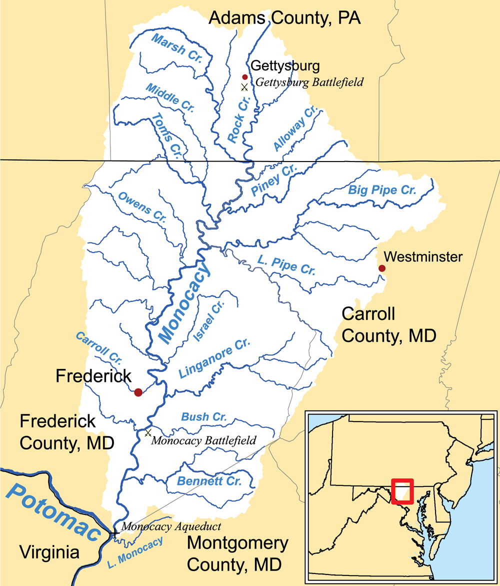
| Description | This is a map of the Monocacy River Watershed I made using USGS and Census Bureau data. |
| Date | 18 May 2006 (original upload date) |
| Source | No machine-readable source provided. Own work assumed (based on copyright claims). |
| Author | No machine-readable author provided. Kmusser assumed (based on copyright claims). |
Licensing
I, the copyright holder of this work, hereby publish it under the following license:
This file is licensed under the
Creative Commons
Attribution-Share Alike 2.5 Generic license.
- You are free:
- to share – to copy, distribute and transmit the work
- to remix – to adapt the work
- Under the following conditions:
- attribution – You must give appropriate credit, provide a link to the license, and indicate if changes were made. You may do so in any reasonable manner, but not in any way that suggests the licensor endorses you or your use.
- share alike – If you remix, transform, or build upon the material, you must distribute your contributions under the same or compatible license as the original.
File history
Click on a date/time to view the file as it appeared at that time.
| Date/Time | Thumbnail | Dimensions | User | Comment | |
|---|---|---|---|---|---|
| current | 01:49, 28 March 2011 |
| 1,000 × 1,172 (544 KB) | Kmusser | higher resolution, more detailed map |
| 22:21, 27 March 2011 |
 | 420 × 421 (36 KB) | Kmusser | Reverted to version as of 20:29, 26 October 2010 - that looks terrible, additions don't match scale of the map - I can work on a more detailed version | |
| 20:01, 27 March 2011 |
 | 268 × 428 (48 KB) | Target for Today | Rock Creek portion of watershed was inaccurate (http://adamswatersheds.org/images/RockFact.pdf), Alloway Cr & Gettysburg were missing, Westminster MD & better Monocacy & Potomac clarity needed added | |
| 20:29, 26 October 2010 |
 | 420 × 421 (36 KB) | Kmusser | trimmed | |
| 21:07, 18 May 2006 |
 | 450 × 450 (33 KB) | Kmusser | ||
| 20:13, 18 May 2006 |
 | 400 × 400 (28 KB) | Kmusser | ||
| 19:14, 18 May 2006 |
 | 400 × 400 (93 KB) | Kmusser | == Summary == This is a map of the Monocacy River Watershed I made using USGS and Census Bureau data. Category:Maps of rivers |
File usage
The following pages on the English Wikipedia use this file (pages on other projects are not listed):
- Alloway Creek (Monocacy River tributary)
- Carroll Creek (Maryland)
- Double Pipe Creek
- Gettysburg campaign
- Linganore Creek
- List of rivers of Maryland
- Marsh Creek (Monocacy River tributary)
- Middle Creek (Toms Creek tributary)
- Monocacy River
- Toms Creek (Monocacy River tributary)
- Union Mills Reservoir
- User:Kmusser/Images
Global file usage
The following other wikis use this file:
- Usage on arz.wikipedia.org
- Usage on da.wikipedia.org
- Usage on de.wikipedia.org
- Usage on fa.wikipedia.org
- Usage on fr.wikipedia.org
- Usage on it.wikipedia.org
- Usage on pl.wikipedia.org
- Usage on ru.wikipedia.org
- Usage on www.wikidata.org
Size of this preview:
511 × 599 pixels. Other resolutions:
205 × 240 pixels |
409 × 480 pixels |
1,000 × 1,172 pixels.
Original file (1,000 × 1,172 pixels, file size: 544 KB, MIME type: image/png)
| This is a file from the
Wikimedia Commons. Information from its
description page there is shown below. Commons is a freely licensed media file repository. You can help. |
Summary
| Description | This is a map of the Monocacy River Watershed I made using USGS and Census Bureau data. |
| Date | 18 May 2006 (original upload date) |
| Source | No machine-readable source provided. Own work assumed (based on copyright claims). |
| Author | No machine-readable author provided. Kmusser assumed (based on copyright claims). |
Licensing
I, the copyright holder of this work, hereby publish it under the following license:
This file is licensed under the
Creative Commons
Attribution-Share Alike 2.5 Generic license.
- You are free:
- to share – to copy, distribute and transmit the work
- to remix – to adapt the work
- Under the following conditions:
- attribution – You must give appropriate credit, provide a link to the license, and indicate if changes were made. You may do so in any reasonable manner, but not in any way that suggests the licensor endorses you or your use.
- share alike – If you remix, transform, or build upon the material, you must distribute your contributions under the same or compatible license as the original.
File history
Click on a date/time to view the file as it appeared at that time.
| Date/Time | Thumbnail | Dimensions | User | Comment | |
|---|---|---|---|---|---|
| current | 01:49, 28 March 2011 |
| 1,000 × 1,172 (544 KB) | Kmusser | higher resolution, more detailed map |
| 22:21, 27 March 2011 |
| 420 × 421 (36 KB) | Kmusser | Reverted to version as of 20:29, 26 October 2010 - that looks terrible, additions don't match scale of the map - I can work on a more detailed version | |
| 20:01, 27 March 2011 |
| 268 × 428 (48 KB) | Target for Today | Rock Creek portion of watershed was inaccurate (http://adamswatersheds.org/images/RockFact.pdf), Alloway Cr & Gettysburg were missing, Westminster MD & better Monocacy & Potomac clarity needed added | |
| 20:29, 26 October 2010 |
| 420 × 421 (36 KB) | Kmusser | trimmed | |
| 21:07, 18 May 2006 |
| 450 × 450 (33 KB) | Kmusser | ||
| 20:13, 18 May 2006 |
| 400 × 400 (28 KB) | Kmusser | ||
| 19:14, 18 May 2006 |
| 400 × 400 (93 KB) | Kmusser | == Summary == This is a map of the Monocacy River Watershed I made using USGS and Census Bureau data. Category:Maps of rivers |
File usage
The following pages on the English Wikipedia use this file (pages on other projects are not listed):
- Alloway Creek (Monocacy River tributary)
- Carroll Creek (Maryland)
- Double Pipe Creek
- Gettysburg campaign
- Linganore Creek
- List of rivers of Maryland
- Marsh Creek (Monocacy River tributary)
- Middle Creek (Toms Creek tributary)
- Monocacy River
- Toms Creek (Monocacy River tributary)
- Union Mills Reservoir
- User:Kmusser/Images
Global file usage
The following other wikis use this file:
- Usage on arz.wikipedia.org
- Usage on da.wikipedia.org
- Usage on de.wikipedia.org
- Usage on fa.wikipedia.org
- Usage on fr.wikipedia.org
- Usage on it.wikipedia.org
- Usage on pl.wikipedia.org
- Usage on ru.wikipedia.org
- Usage on www.wikidata.org