Size of this preview:
275 × 600 pixels. Other resolutions:
110 × 240 pixels |
327 × 713 pixels.
Original file (327 × 713 pixels, file size: 14 KB, MIME type: image/png)
| This is a file from the
Wikimedia Commons. Information from its
description page there is shown below. Commons is a freely licensed media file repository. You can help. |
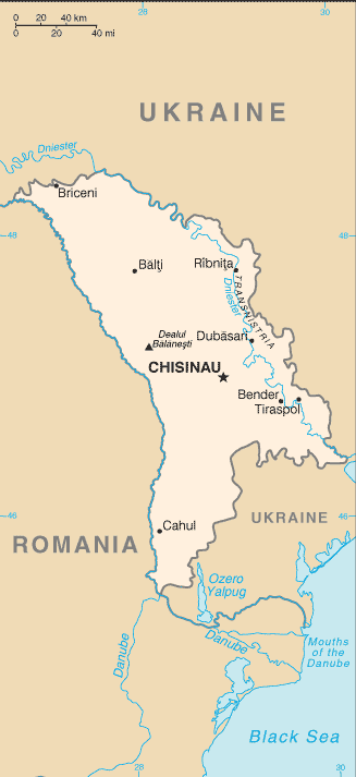
This image is in the
public domain because it contains materials that originally came from the United States
Central Intelligence Agency's
World Factbook.
|
 |
File history
Click on a date/time to view the file as it appeared at that time.
| Date/Time | Thumbnail | Dimensions | User | Comment | |
|---|---|---|---|---|---|
| current | 14:18, 30 April 2022 |
| 327 × 713 (14 KB) | Claude Zygiel | Uploaded separately the enriched version following Pinkerton's advice. |
| 16:29, 15 April 2022 |
 | 327 × 580 (146 KB) | Claude Zygiel | Adding useful details to a current geographic map is very different from "manipulating a historical map". Please tolerate this. | |
| 04:32, 27 September 2021 |
 | 327 × 713 (14 KB) | GPinkerton | Reverted to version as of 09:16, 27 March 2005 (UTC) COM:CROP, manipulation of historical document | |
| 18:38, 9 July 2020 |
 | 327 × 662 (34 KB) | Claude Zygiel | Development and Autonomous Regions & Extreme Points (red) | |
| 09:16, 27 March 2005 |
 | 327 × 713 (14 KB) | Wolfman~commonswiki | {{CIA-map}} |
File usage
The following pages on the English Wikipedia use this file (pages on other projects are not listed):
Global file usage
The following other wikis use this file:
- Usage on be-tarask.wikipedia.org
- Usage on ca.wikipedia.org
- Usage on en.wikisource.org
- Usage on fa.wikipedia.org
- Usage on gom.wikipedia.org
- Usage on he.wikipedia.org
- Usage on hu.wikipedia.org
- Usage on hu.wiktionary.org
- Usage on mr.wikipedia.org
- Usage on sq.wikipedia.org
- Usage on th.wikipedia.org
- Usage on tr.wikipedia.org
- Usage on udm.wikipedia.org
- Usage on vls.wikipedia.org
- Usage on www.wikidata.org
- Usage on zh-min-nan.wikipedia.org
- Usage on zh.wikipedia.org
Size of this preview:
275 × 600 pixels. Other resolutions:
110 × 240 pixels |
327 × 713 pixels.
Original file (327 × 713 pixels, file size: 14 KB, MIME type: image/png)
| This is a file from the
Wikimedia Commons. Information from its
description page there is shown below. Commons is a freely licensed media file repository. You can help. |
This image is in the
public domain because it contains materials that originally came from the United States
Central Intelligence Agency's
World Factbook.
|
|
File history
Click on a date/time to view the file as it appeared at that time.
| Date/Time | Thumbnail | Dimensions | User | Comment | |
|---|---|---|---|---|---|
| current | 14:18, 30 April 2022 |
| 327 × 713 (14 KB) | Claude Zygiel | Uploaded separately the enriched version following Pinkerton's advice. |
| 16:29, 15 April 2022 |
| 327 × 580 (146 KB) | Claude Zygiel | Adding useful details to a current geographic map is very different from "manipulating a historical map". Please tolerate this. | |
| 04:32, 27 September 2021 |
| 327 × 713 (14 KB) | GPinkerton | Reverted to version as of 09:16, 27 March 2005 (UTC) COM:CROP, manipulation of historical document | |
| 18:38, 9 July 2020 |
| 327 × 662 (34 KB) | Claude Zygiel | Development and Autonomous Regions & Extreme Points (red) | |
| 09:16, 27 March 2005 |
| 327 × 713 (14 KB) | Wolfman~commonswiki | {{CIA-map}} |
File usage
The following pages on the English Wikipedia use this file (pages on other projects are not listed):
Global file usage
The following other wikis use this file:
- Usage on be-tarask.wikipedia.org
- Usage on ca.wikipedia.org
- Usage on en.wikisource.org
- Usage on fa.wikipedia.org
- Usage on gom.wikipedia.org
- Usage on he.wikipedia.org
- Usage on hu.wikipedia.org
- Usage on hu.wiktionary.org
- Usage on mr.wikipedia.org
- Usage on sq.wikipedia.org
- Usage on th.wikipedia.org
- Usage on tr.wikipedia.org
- Usage on udm.wikipedia.org
- Usage on vls.wikipedia.org
- Usage on www.wikidata.org
- Usage on zh-min-nan.wikipedia.org
- Usage on zh.wikipedia.org