Photos • Location


Size of this PNG preview of this SVG file:
334 × 598 pixels. Other resolutions:
134 × 240 pixels |
268 × 480 pixels |
428 × 768 pixels |
571 × 1,024 pixels |
1,143 × 2,048 pixels |
1,631 × 2,922 pixels.
Original file (SVG file, nominally 1,631 × 2,922 pixels, file size: 2.27 MB)
| This is a file from the
Wikimedia Commons. Information from its
description page there is shown below. Commons is a freely licensed media file repository. You can help. |
Summary
| Description |
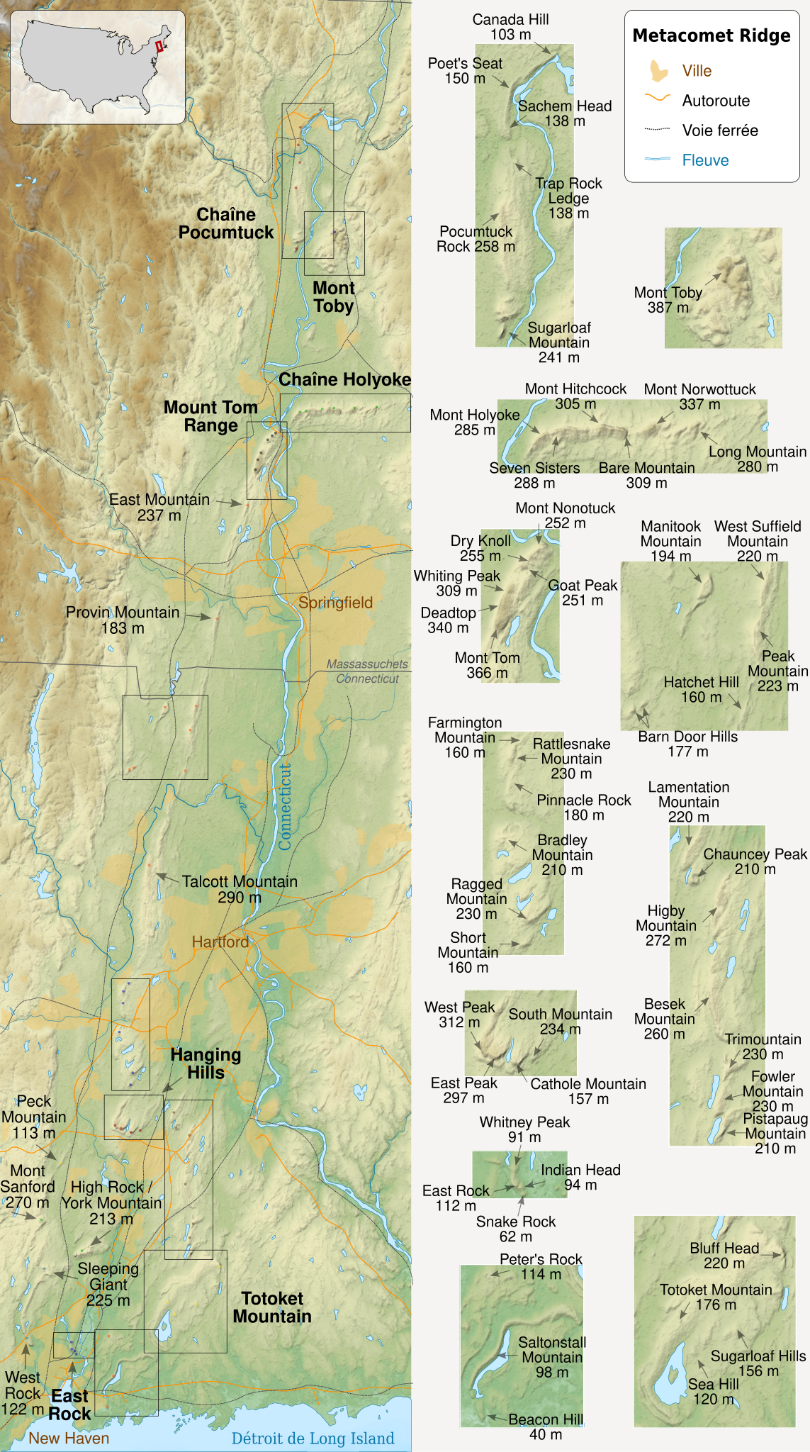
English: Map of
Metacomet Ridge, a low fault-block mountain ridge, part of the Appalachian Mountains, extends from Connecticut to Massachusetts, United States of America. Equirectangular projection, WGS84 datum. Français :
fr: Carte du Métacomet Ridge, une arête rocheuse de basse altitude faisant partie des Appalaches, répartie sur les états du Connecticut et du Massachusetts, aux États-Unis d'Amérique. Projection équirectangulaire ; système géodésique WGS 84. |
||||
| Date | (UTC) | ||||
| Source |
Own work. Source :
|
||||
| Author | Sémhur ( talk) | ||||
| Other versions | |||||
| Attribution ( required by the license) | © Sémhur / Wikimedia Commons / | ||||
| SVG | W3C-validity not checked.
|
||||
| Graphic Lab | |||||
| North location |
|
||||
| South location |
|

Licensing
I, the copyright holder of this work, hereby publish it under the following licenses:
| Copyleft: This work of art is free; you can redistribute it and/or modify it according to terms of the Free Art License. You will find a specimen of this license on the Copyleft Attitude site as well as on other sites. |
This file is licensed under the
Creative Commons Attribution-Share Alike
Attribution-Share Alike 4.0 International,
3.0 Unported,
2.5 Generic,
2.0 Generic and
1.0 Generic license.
- You are free:
- to share – to copy, distribute and transmit the work
- to remix – to adapt the work
- Under the following conditions:
- attribution – You must give appropriate credit, provide a link to the license, and indicate if changes were made. You may do so in any reasonable manner, but not in any way that suggests the licensor endorses you or your use.
- share alike – If you remix, transform, or build upon the material, you must distribute your contributions under the same or compatible license as the original.
You may select the license of your choice.
File history
Click on a date/time to view the file as it appeared at that time.
| Date/Time | Thumbnail | Dimensions | User | Comment | |
|---|---|---|---|---|---|
| current | 16:52, 26 September 2010 |
| 1,631 × 2,922 (2.27 MB) | Sémhur | + location map (Blank US Map, Mainland with no States.svg) |
| 20:23, 21 September 2010 |
 | 1,631 × 2,922 (2.26 MB) | Sémhur | == {{int:filedesc}} == {{Information |Description={{Multilingual description |en= Map of Metacomet Ridge, a low fault-block mountain ridge, part of the Appalachian Mountains, extends from Connecticut to Massachusetts, United States |
File usage
No pages on the English Wikipedia use this file (pages on other projects are not listed).
Global file usage
The following other wikis use this file:
- Usage on fr.wikipedia.org
- Utilisateur:Gemini1980
- Portail:États-Unis/Articles de qualité
- Metacomet Ridge
- Wikipédia:Sélection/Amérique
- Wikipédia:Sélection/Massachusetts
- Portail:Connecticut
- Wikipédia:Sélection/Connecticut
- Wikipédia:Sélection/États-Unis/Par État
- Wikipédia:Sélection/Montagne
- Wikipédia:Lumière sur/Décembre 2010
- Wikipédia:Atelier graphique/Cartes/Archives/octobre 2010
- Wikipédia:Lumière sur/Metacomet Ridge
- Wikipédia:Sélection/États-Unis/Articles de qualité
- Wikipédia:Lumière sur/Juillet 2018
Size of this PNG preview of this SVG file:
334 × 598 pixels. Other resolutions:
134 × 240 pixels |
268 × 480 pixels |
428 × 768 pixels |
571 × 1,024 pixels |
1,143 × 2,048 pixels |
1,631 × 2,922 pixels.
Original file (SVG file, nominally 1,631 × 2,922 pixels, file size: 2.27 MB)
| This is a file from the
Wikimedia Commons. Information from its
description page there is shown below. Commons is a freely licensed media file repository. You can help. |
Summary
| Description |
English: Map of
Metacomet Ridge, a low fault-block mountain ridge, part of the Appalachian Mountains, extends from Connecticut to Massachusetts, United States of America. Equirectangular projection, WGS84 datum. Français :
fr: Carte du Métacomet Ridge, une arête rocheuse de basse altitude faisant partie des Appalaches, répartie sur les états du Connecticut et du Massachusetts, aux États-Unis d'Amérique. Projection équirectangulaire ; système géodésique WGS 84. |
||||
| Date | (UTC) | ||||
| Source |
Own work. Source :
|
||||
| Author | Sémhur ( talk) | ||||
| Other versions | |||||
| Attribution ( required by the license) | © Sémhur / Wikimedia Commons / | ||||
| SVG | W3C-validity not checked.
|
||||
| Graphic Lab | |||||
| North location |
|
||||
| South location |
|
Licensing
I, the copyright holder of this work, hereby publish it under the following licenses:
| Copyleft: This work of art is free; you can redistribute it and/or modify it according to terms of the Free Art License. You will find a specimen of this license on the Copyleft Attitude site as well as on other sites. |
This file is licensed under the
Creative Commons Attribution-Share Alike
Attribution-Share Alike 4.0 International,
3.0 Unported,
2.5 Generic,
2.0 Generic and
1.0 Generic license.
- You are free:
- to share – to copy, distribute and transmit the work
- to remix – to adapt the work
- Under the following conditions:
- attribution – You must give appropriate credit, provide a link to the license, and indicate if changes were made. You may do so in any reasonable manner, but not in any way that suggests the licensor endorses you or your use.
- share alike – If you remix, transform, or build upon the material, you must distribute your contributions under the same or compatible license as the original.
You may select the license of your choice.
File history
Click on a date/time to view the file as it appeared at that time.
| Date/Time | Thumbnail | Dimensions | User | Comment | |
|---|---|---|---|---|---|
| current | 16:52, 26 September 2010 |
| 1,631 × 2,922 (2.27 MB) | Sémhur | + location map (Blank US Map, Mainland with no States.svg) |
| 20:23, 21 September 2010 |
| 1,631 × 2,922 (2.26 MB) | Sémhur | == {{int:filedesc}} == {{Information |Description={{Multilingual description |en= Map of Metacomet Ridge, a low fault-block mountain ridge, part of the Appalachian Mountains, extends from Connecticut to Massachusetts, United States |
File usage
No pages on the English Wikipedia use this file (pages on other projects are not listed).
Global file usage
The following other wikis use this file:
- Usage on fr.wikipedia.org
- Utilisateur:Gemini1980
- Portail:États-Unis/Articles de qualité
- Metacomet Ridge
- Wikipédia:Sélection/Amérique
- Wikipédia:Sélection/Massachusetts
- Portail:Connecticut
- Wikipédia:Sélection/Connecticut
- Wikipédia:Sélection/États-Unis/Par État
- Wikipédia:Sélection/Montagne
- Wikipédia:Lumière sur/Décembre 2010
- Wikipédia:Atelier graphique/Cartes/Archives/octobre 2010
- Wikipédia:Lumière sur/Metacomet Ridge
- Wikipédia:Sélection/États-Unis/Articles de qualité
- Wikipédia:Lumière sur/Juillet 2018