
Size of this preview:
800 × 566 pixels. Other resolutions:
320 × 226 pixels |
640 × 453 pixels |
1,024 × 724 pixels |
1,280 × 905 pixels |
2,560 × 1,810 pixels |
3,507 × 2,480 pixels.
Original file (3,507 × 2,480 pixels, file size: 802 KB, MIME type: image/png)
| This is a file from the
Wikimedia Commons. Information from its
description page there is shown below. Commons is a freely licensed media file repository. You can help. |
Summary
| Description |
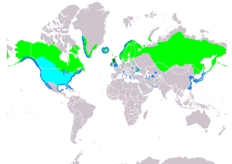
Slovenčina: Mapa rozšírenia potápača prostredného (Mergus serrator) podľa IUCN verzia 2018.2 ,
legenda: Hniezdiaci, výskyt v letnom období (#00FF00), Hniezdiaci, celoročný výskyt (#008000), Migrujúci (#00FFFF), Nehniezdiaci (#007FFF) English: Map of red-breasted merganser (Mergus serrator) according to IUCN version 2018.2 , Legend: Extant, breeding (#00FF00), Extant, resident (#008000), Extant, passage (#00FFFF), Extant, non-breeding (#007FFF) |
| Date | |
| Source |
Made with Natural Earth. Free vector and raster map data @ naturalearthdata.com. Range map from BirdLife International 2018. Mergus serrator. The IUCN Red List of Threatened Species 2018: e.T22680485A132053220. https://dx.doi.org/10.2305/IUCN.UK.2018-2.RLTS.T22680485A132053220.en. Downloaded on 24 January 2019 as visual indicator of distribution. |
| Author | SanoAK: Alexander Kürthy |
Licensing

This file is licensed under the
Creative Commons
Attribution-Share Alike 3.0 Unported license.
Attribution:
IUCN Red List of Threatened Species, species assessors and the
authors of the spatial data.
- You are free:
- to share – to copy, distribute and transmit the work
- to remix – to adapt the work
- Under the following conditions:
- attribution – You must give appropriate credit, provide a link to the license, and indicate if changes were made. You may do so in any reasonable manner, but not in any way that suggests the licensor endorses you or your use.
- share alike – If you remix, transform, or build upon the material, you must distribute your contributions under the same or compatible license as the original.
File history
Click on a date/time to view the file as it appeared at that time.
| Date/Time | Thumbnail | Dimensions | User | Comment | |
|---|---|---|---|---|---|
| current | 17:34, 24 January 2019 |
| 3,507 × 2,480 (802 KB) | SanoAK | User created page with UploadWizard |
File usage
The following pages on the English Wikipedia use this file (pages on other projects are not listed):
Global file usage
The following other wikis use this file:
- Usage on an.wikipedia.org
- Usage on bn.wikipedia.org
- Usage on ceb.wikipedia.org
- Usage on de.wikipedia.org
- Usage on eo.wikipedia.org
- Usage on es.wikipedia.org
- Usage on frr.wikipedia.org
- Usage on gl.wikipedia.org
- Usage on hu.wikipedia.org
- Usage on ko.wikipedia.org
- Usage on lij.wikipedia.org
- Usage on no.wikipedia.org
- Usage on pl.wikipedia.org
- Usage on ru.wikipedia.org
- Usage on sk.wikipedia.org
- Usage on sr.wikipedia.org
- Usage on uk.wikipedia.org
- Usage on uz.wikipedia.org
- Usage on zh.wikipedia.org
Metadata
Size of this preview:
800 × 566 pixels. Other resolutions:
320 × 226 pixels |
640 × 453 pixels |
1,024 × 724 pixels |
1,280 × 905 pixels |
2,560 × 1,810 pixels |
3,507 × 2,480 pixels.
Original file (3,507 × 2,480 pixels, file size: 802 KB, MIME type: image/png)
| This is a file from the
Wikimedia Commons. Information from its
description page there is shown below. Commons is a freely licensed media file repository. You can help. |
Summary
| Description |
Slovenčina: Mapa rozšírenia potápača prostredného (Mergus serrator) podľa IUCN verzia 2018.2 ,
legenda: Hniezdiaci, výskyt v letnom období (#00FF00), Hniezdiaci, celoročný výskyt (#008000), Migrujúci (#00FFFF), Nehniezdiaci (#007FFF) English: Map of red-breasted merganser (Mergus serrator) according to IUCN version 2018.2 , Legend: Extant, breeding (#00FF00), Extant, resident (#008000), Extant, passage (#00FFFF), Extant, non-breeding (#007FFF) |
| Date | |
| Source |
Made with Natural Earth. Free vector and raster map data @ naturalearthdata.com. Range map from BirdLife International 2018. Mergus serrator. The IUCN Red List of Threatened Species 2018: e.T22680485A132053220. https://dx.doi.org/10.2305/IUCN.UK.2018-2.RLTS.T22680485A132053220.en. Downloaded on 24 January 2019 as visual indicator of distribution. |
| Author | SanoAK: Alexander Kürthy |
Licensing
This file is licensed under the
Creative Commons
Attribution-Share Alike 3.0 Unported license.
Attribution:
IUCN Red List of Threatened Species, species assessors and the
authors of the spatial data.
- You are free:
- to share – to copy, distribute and transmit the work
- to remix – to adapt the work
- Under the following conditions:
- attribution – You must give appropriate credit, provide a link to the license, and indicate if changes were made. You may do so in any reasonable manner, but not in any way that suggests the licensor endorses you or your use.
- share alike – If you remix, transform, or build upon the material, you must distribute your contributions under the same or compatible license as the original.
File history
Click on a date/time to view the file as it appeared at that time.
| Date/Time | Thumbnail | Dimensions | User | Comment | |
|---|---|---|---|---|---|
| current | 17:34, 24 January 2019 |
| 3,507 × 2,480 (802 KB) | SanoAK | User created page with UploadWizard |
File usage
The following pages on the English Wikipedia use this file (pages on other projects are not listed):
Global file usage
The following other wikis use this file:
- Usage on an.wikipedia.org
- Usage on bn.wikipedia.org
- Usage on ceb.wikipedia.org
- Usage on de.wikipedia.org
- Usage on eo.wikipedia.org
- Usage on es.wikipedia.org
- Usage on frr.wikipedia.org
- Usage on gl.wikipedia.org
- Usage on hu.wikipedia.org
- Usage on ko.wikipedia.org
- Usage on lij.wikipedia.org
- Usage on no.wikipedia.org
- Usage on pl.wikipedia.org
- Usage on ru.wikipedia.org
- Usage on sk.wikipedia.org
- Usage on sr.wikipedia.org
- Usage on uk.wikipedia.org
- Usage on uz.wikipedia.org
- Usage on zh.wikipedia.org