
Size of this PNG preview of this SVG file:
543 × 599 pixels. Other resolutions:
217 × 240 pixels |
435 × 480 pixels |
696 × 768 pixels |
927 × 1,024 pixels |
1,855 × 2,048 pixels |
1,000 × 1,104 pixels.
Original file (SVG file, nominally 1,000 × 1,104 pixels, file size: 685 KB)
| This is a file from the
Wikimedia Commons. Information from its
description page there is shown below. Commons is a freely licensed media file repository. You can help. |
.svg)
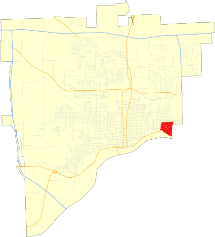
| Description | Map of the McClellan Heights Historic District in Davenport, Iowa. Created in QuantamGIS and finished in Inkscape. |
| Date | |
| Source | City of Davenport |
| Author | Fredddie |
| Permission ( Reusing this file) |
Creative Commons Attribution ShareAlike 3.0 |
| SVG development |
Licensing
This file is licensed under the
Creative Commons
Attribution-Share Alike 3.0 Unported license.
- You are free:
- to share – to copy, distribute and transmit the work
- to remix – to adapt the work
- Under the following conditions:
- attribution – You must give appropriate credit, provide a link to the license, and indicate if changes were made. You may do so in any reasonable manner, but not in any way that suggests the licensor endorses you or your use.
- share alike – If you remix, transform, or build upon the material, you must distribute your contributions under the same or compatible license as the original.
File history
Click on a date/time to view the file as it appeared at that time.
| Date/Time | Thumbnail | Dimensions | User | Comment | |
|---|---|---|---|---|---|
| current | 18:15, 16 April 2010 |
| 1,000 × 1,104 (685 KB) | Fredddie | added streets and roads |
| 06:57, 4 April 2010 |
 | 905 × 1,000 (12 KB) | Fredddie | {{Information |Description=Map of the McClellan Heights Historic District in Davenport, Iowa. Created in QuantamGIS and finished in Inkscape. |Source=City of Davenport |Date=April 4, 2010 |Author= Fredddie |Permissi |
File usage
The following pages on the English Wikipedia use this file (pages on other projects are not listed):
Metadata
.svg)
Size of this PNG preview of this SVG file:
543 × 599 pixels. Other resolutions:
217 × 240 pixels |
435 × 480 pixels |
696 × 768 pixels |
927 × 1,024 pixels |
1,855 × 2,048 pixels |
1,000 × 1,104 pixels.
Original file (SVG file, nominally 1,000 × 1,104 pixels, file size: 685 KB)
| This is a file from the
Wikimedia Commons. Information from its
description page there is shown below. Commons is a freely licensed media file repository. You can help. |
| Description | Map of the McClellan Heights Historic District in Davenport, Iowa. Created in QuantamGIS and finished in Inkscape. |
| Date | |
| Source | City of Davenport |
| Author | Fredddie |
| Permission ( Reusing this file) |
Creative Commons Attribution ShareAlike 3.0 |
| SVG development |
Licensing
This file is licensed under the
Creative Commons
Attribution-Share Alike 3.0 Unported license.
- You are free:
- to share – to copy, distribute and transmit the work
- to remix – to adapt the work
- Under the following conditions:
- attribution – You must give appropriate credit, provide a link to the license, and indicate if changes were made. You may do so in any reasonable manner, but not in any way that suggests the licensor endorses you or your use.
- share alike – If you remix, transform, or build upon the material, you must distribute your contributions under the same or compatible license as the original.
File history
Click on a date/time to view the file as it appeared at that time.
| Date/Time | Thumbnail | Dimensions | User | Comment | |
|---|---|---|---|---|---|
| current | 18:15, 16 April 2010 |
| 1,000 × 1,104 (685 KB) | Fredddie | added streets and roads |
| 06:57, 4 April 2010 |
| 905 × 1,000 (12 KB) | Fredddie | {{Information |Description=Map of the McClellan Heights Historic District in Davenport, Iowa. Created in QuantamGIS and finished in Inkscape. |Source=City of Davenport |Date=April 4, 2010 |Author= Fredddie |Permissi |
File usage
The following pages on the English Wikipedia use this file (pages on other projects are not listed):