
Original file (SVG file, nominally 828 × 693 pixels, file size: 304 KB)
| This is a file from the
Wikimedia Commons. Information from its
description page there is shown below. Commons is a freely licensed media file repository. You can help. |
.svg)
Summary
| Description |
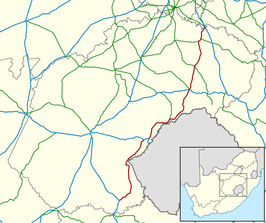
English: Map showing the route of the R26 provincial route, highlighted in red, in the Free State province, South Africa. National routes are shown in blue, and other provincial routes in green. |
| Date | |
| Source | Geodata from OpenStreetMap |
| Author | Htonl |
Licensing
- You are free:
- to share – to copy, distribute and transmit the work
- to remix – to adapt the work
- Under the following conditions:
- attribution – You must give appropriate credit, provide a link to the license, and indicate if changes were made. You may do so in any reasonable manner, but not in any way that suggests the licensor endorses you or your use.
- share alike – If you remix, transform, or build upon the material, you must distribute your contributions under the same or compatible license as the original.
|
|
This work contains information from
OpenStreetMap, which is made available under the
Open Database License (ODbL).
The ODbL does not require any particular license for maps produced from ODbL data. Prior to 1 August 2020, map tiles produced by the OpenStreetMap Foundation were licensed under the CC-BY-SA-2.0 license. Maps produced by other people may be subject to other licences. |
File history
Click on a date/time to view the file as it appeared at that time.
| Date/Time | Thumbnail | Dimensions | User | Comment | |
|---|---|---|---|---|---|
| current | 22:44, 7 September 2014 |
| 828 × 693 (304 KB) | Htonl | Style and projection |
| 17:09, 28 April 2010 |
 | 1,002 × 784 (1.71 MB) | Htonl | {{Information |Description={{en|1=Map showing the route of the R26 major regional road, highlighted in red, in the Free State province, South Africa. National roads are shown in blue, and other major regional roads in green.}} |Source=Geodata from [[w:en: |
File usage
Global file usage
The following other wikis use this file:
- Usage on af.wikipedia.org
- Usage on www.wikidata.org
Metadata
.svg)
Original file (SVG file, nominally 828 × 693 pixels, file size: 304 KB)
| This is a file from the
Wikimedia Commons. Information from its
description page there is shown below. Commons is a freely licensed media file repository. You can help. |
Summary
| Description |
English: Map showing the route of the R26 provincial route, highlighted in red, in the Free State province, South Africa. National routes are shown in blue, and other provincial routes in green. |
| Date | |
| Source | Geodata from OpenStreetMap |
| Author | Htonl |
Licensing
- You are free:
- to share – to copy, distribute and transmit the work
- to remix – to adapt the work
- Under the following conditions:
- attribution – You must give appropriate credit, provide a link to the license, and indicate if changes were made. You may do so in any reasonable manner, but not in any way that suggests the licensor endorses you or your use.
- share alike – If you remix, transform, or build upon the material, you must distribute your contributions under the same or compatible license as the original.
|
|
This work contains information from
OpenStreetMap, which is made available under the
Open Database License (ODbL).
The ODbL does not require any particular license for maps produced from ODbL data. Prior to 1 August 2020, map tiles produced by the OpenStreetMap Foundation were licensed under the CC-BY-SA-2.0 license. Maps produced by other people may be subject to other licences. |
File history
Click on a date/time to view the file as it appeared at that time.
| Date/Time | Thumbnail | Dimensions | User | Comment | |
|---|---|---|---|---|---|
| current | 22:44, 7 September 2014 |
| 828 × 693 (304 KB) | Htonl | Style and projection |
| 17:09, 28 April 2010 |
| 1,002 × 784 (1.71 MB) | Htonl | {{Information |Description={{en|1=Map showing the route of the R26 major regional road, highlighted in red, in the Free State province, South Africa. National roads are shown in blue, and other major regional roads in green.}} |Source=Geodata from [[w:en: |
File usage
Global file usage
The following other wikis use this file:
- Usage on af.wikipedia.org
- Usage on www.wikidata.org