
Size of this preview:
800 × 593 pixels. Other resolutions:
320 × 237 pixels |
640 × 474 pixels |
1,024 × 759 pixels |
1,280 × 949 pixels |
2,199 × 1,630 pixels.
Original file (2,199 × 1,630 pixels, file size: 488 KB, MIME type: image/png)
| This is a file from the
Wikimedia Commons. Information from its
description page there is shown below. Commons is a freely licensed media file repository. You can help. |
Summary
| Description |
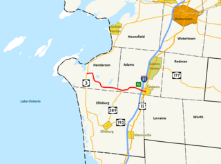
English: Map of
New York State Route 178, in Jefferson County, New York |
| Date | |
| Source | Own work |
| Author | Smb6009 |
Legend for this map
The thick Red line represents
![]()
| Background Type |
|---|
| Town |
| City |
| Village |
| Census-Designated Place |
| Reservation |
Map data based on several government-produced GIS sources, including: National Highway Planning Network Data
Licensing
I, the copyright holder of this work, hereby publish it under the following licenses:
This file is licensed under the
Creative Commons
Attribution-Share Alike 3.0 Unported license.
- You are free:
- to share – to copy, distribute and transmit the work
- to remix – to adapt the work
- Under the following conditions:
- attribution – You must give appropriate credit, provide a link to the license, and indicate if changes were made. You may do so in any reasonable manner, but not in any way that suggests the licensor endorses you or your use.
- share alike – If you remix, transform, or build upon the material, you must distribute your contributions under the same or compatible license as the original.

|
Permission is granted to copy, distribute and/or modify this document under the terms of the GNU Free Documentation License, Version 1.2 or any later version published by the Free Software Foundation; with no Invariant Sections, no Front-Cover Texts, and no Back-Cover Texts. A copy of the license is included in the section entitled GNU Free Documentation License. |
You may select the license of your choice.
File history
Click on a date/time to view the file as it appeared at that time.
| Date/Time | Thumbnail | Dimensions | User | Comment | |
|---|---|---|---|---|---|
| current | 22:30, 13 August 2010 |
| 2,199 × 1,630 (488 KB) | Smb6009 | Reverted to version as of 04:09, 11 August 2010 -Retain details for viewing exclusively on this image page |
| 02:15, 12 August 2010 |
 | 1,468 × 952 (207 KB) | Smb6009 | correct version | |
| 02:14, 12 August 2010 |
 | 1,468 × 952 (207 KB) | Smb6009 | forgot to crop | |
| 02:12, 12 August 2010 |
 | 1,656 × 1,285 (347 KB) | Smb6009 | Made map more aesthetically pleasing for an infobox | |
| 04:09, 11 August 2010 |
 | 2,199 × 1,630 (488 KB) | Smb6009 | {{Information |Description={{en|1=Map of New York State Route 178, in Jefferson County, New York}} |Source={{own}} |Author= Smb6009 |Date=2010-08-11 |Permission= |other_versions= }} '''Legend for this map''' The thick '''<span style=" |
File usage
No pages on the English Wikipedia use this file (pages on other projects are not listed).
Size of this preview:
800 × 593 pixels. Other resolutions:
320 × 237 pixels |
640 × 474 pixels |
1,024 × 759 pixels |
1,280 × 949 pixels |
2,199 × 1,630 pixels.
Original file (2,199 × 1,630 pixels, file size: 488 KB, MIME type: image/png)
| This is a file from the
Wikimedia Commons. Information from its
description page there is shown below. Commons is a freely licensed media file repository. You can help. |
Summary
| Description |
English: Map of
New York State Route 178, in Jefferson County, New York |
| Date | |
| Source | Own work |
| Author | Smb6009 |
Legend for this map
The thick Red line represents
![]()
| Background Type |
|---|
| Town |
| City |
| Village |
| Census-Designated Place |
| Reservation |
Map data based on several government-produced GIS sources, including: National Highway Planning Network Data
Licensing
I, the copyright holder of this work, hereby publish it under the following licenses:
This file is licensed under the
Creative Commons
Attribution-Share Alike 3.0 Unported license.
- You are free:
- to share – to copy, distribute and transmit the work
- to remix – to adapt the work
- Under the following conditions:
- attribution – You must give appropriate credit, provide a link to the license, and indicate if changes were made. You may do so in any reasonable manner, but not in any way that suggests the licensor endorses you or your use.
- share alike – If you remix, transform, or build upon the material, you must distribute your contributions under the same or compatible license as the original.
|
|
Permission is granted to copy, distribute and/or modify this document under the terms of the GNU Free Documentation License, Version 1.2 or any later version published by the Free Software Foundation; with no Invariant Sections, no Front-Cover Texts, and no Back-Cover Texts. A copy of the license is included in the section entitled GNU Free Documentation License. |
You may select the license of your choice.
File history
Click on a date/time to view the file as it appeared at that time.
| Date/Time | Thumbnail | Dimensions | User | Comment | |
|---|---|---|---|---|---|
| current | 22:30, 13 August 2010 |
| 2,199 × 1,630 (488 KB) | Smb6009 | Reverted to version as of 04:09, 11 August 2010 -Retain details for viewing exclusively on this image page |
| 02:15, 12 August 2010 |
| 1,468 × 952 (207 KB) | Smb6009 | correct version | |
| 02:14, 12 August 2010 |
| 1,468 × 952 (207 KB) | Smb6009 | forgot to crop | |
| 02:12, 12 August 2010 |
| 1,656 × 1,285 (347 KB) | Smb6009 | Made map more aesthetically pleasing for an infobox | |
| 04:09, 11 August 2010 |
| 2,199 × 1,630 (488 KB) | Smb6009 | {{Information |Description={{en|1=Map of New York State Route 178, in Jefferson County, New York}} |Source={{own}} |Author= Smb6009 |Date=2010-08-11 |Permission= |other_versions= }} '''Legend for this map''' The thick '''<span style=" |
File usage
No pages on the English Wikipedia use this file (pages on other projects are not listed).