
Original file (SVG file, nominally 1,470 × 777 pixels, file size: 338 KB)
| This is a file from the
Wikimedia Commons. Information from its
description page there is shown below. Commons is a freely licensed media file repository. You can help. |
Summary
| Description |
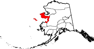
English: This is a locator map showing
Nome Census Area in Alaska |
| Date | |
| Source |
Own work: English: The maps use data from
nationalatlas.gov, specifically
countyp020.tar.gz on the
Raw Data Download page. The maps also use state outline data from
statesp020.tar.gz. The Florida maps use
hydrogm020.tar.gz to display Lake Okeechobee. |
| Author | David Benbennick |
Licensing
| I, the copyright holder of this work, release this work into the
public domain. This applies worldwide. In some countries this may not be legally possible; if so: I grant anyone the right to use this work for any purpose, without any conditions, unless such conditions are required by law. |
File history
Click on a date/time to view the file as it appeared at that time.
| Date/Time | Thumbnail | Dimensions | User | Comment | |
|---|---|---|---|---|---|
| current | 19:28, 5 March 2006 |
| 1,470 × 777 (338 KB) | David Benbennick | {{subst:User:Dbenbenn/clm|county=Nome Census Area|state=Alaska|type=borough and census area}} |
File usage
More than 100 pages use this file. The following list shows the first 100 pages that use this file only. A full list is available.
- Andreafsky Wilderness
- Anvil City Science Academy
- Arctic River
- Army Peak
- Besboro Island
- Bluff, Alaska
- Bonanza River
- Brevig Mission, Alaska
- Bureau of Indian Affairs Unalakleet School
- Cape Denbigh
- Cape Nome Roadhouse
- Cape Prince of Wales
- Council, Alaska
- Council Airport
- Demon Creek
- Devil Mountain (Alaska)
- Dickson, Alaska
- Diomede, Alaska (town)
- Discovery Saloon
- Eldorado River
- Elim, Alaska
- Flambeau River (Alaska)
- Fort Davis, Alaska
- Fort St. Michael
- Gambell, Alaska
- Gambell Sites
- Golovin, Alaska
- Granite Mountain Air Station
- Haycock, Alaska
- Haycock Airport
- Imuruk Basin
- Imuruk Lake volcanic field
- Iñupiat
- Jacob Berger House
- Kigluaik Mountains
- King Island (Alaska)
- Kookooligit Mountains
- Koyuk, Alaska
- Koyuk Alfred Adams Airport
- Kuzitrin River
- List of boroughs and census areas in Alaska
- Lopp Lagoon
- Lost Jim Lava Flow
- Lost River 1 Airport
- Mary's Igloo, Alaska
- Mint River
- Moses Point Army Airfield
- Mount Bendeleben
- Mount Osborn
- National Register of Historic Places listings in Nome Census Area, Alaska
- Nil Desperandum Gulch
- Niukluk River
- Nome, Alaska
- Nome Census Area, Alaska
- Nome–Teller Highway
- Norton Sound
- Nugnugaluktuk River
- Old St. Joseph's Catholic Church
- Pilgrim Hot Springs
- Port Clarence, Alaska
- Port Clarence Coast Guard Station
- Punuk Islands
- Sarichef Island
- Savoonga, Alaska
- Shaktoolik, Alaska
- Shaktoolik Airport
- Shishmaref, Alaska
- Shishmaref Inlet
- Sledge Island
- Snake River (Nome, Alaska)
- Solomon, Alaska
- Solomon Roadhouse
- St. Michael, Alaska
- St. Michael Airport
- St. Michael Island
- St. Michael volcanic field
- Stebbins, Alaska
- Stebbins Airport
- Stuart Island, Alaska
- Teller, Alaska
- Tin City, Alaska
- Unalakleet, Alaska
- Unalakleet Airport
- Unorganized Borough, Alaska
- Wales, Alaska
- Wales Airport (Alaska)
- Western Arctic National Parklands
- White Mountain, Alaska
- White Mountain Airport
- York, Alaska
- York Mountains
- Yupiit Piciryarait Cultural Center
- User:AridCeption/sandbox
- User:Nyttend/County templates/AK
- Wikipedia:WikiProject Alaska
- File talk:Map of Alaska highlighting Nome Census Area.svg
- Template:NomeAK-geo-stub
- Template:Nome Census Area, Alaska
- Template:Unorganized Borough, Alaska
- Category:Populated places in Nome Census Area, Alaska
View more links to this file.
Global file usage
The following other wikis use this file:
- Usage on az.wikipedia.org
- Usage on bpy.wikipedia.org
- Usage on ca.wikipedia.org
- Brevig Mission
- Diomede
- Elim (Alaska)
- Gambell
- Golovin
- Koyuk
- Nome (Alaska)
- Port Clarence
- Savoonga
- Shaktoolik
- Shishmaref
- St. Michael (Alaska)
- Stebbins
- Teller (Alaska)
- Unalakleet
- Wales (Alaska)
- White Mountain
- Llista de boroughs i àrees censals d'Alaska
- Plantilla:Àrea censal de Nome
- Categoria:Àrea censal de Nome
- Usage on ce.wikipedia.org
- Usage on cy.wikipedia.org
- Usage on de.wikipedia.org
- Usage on es.wikipedia.org
- Usage on fi.wikipedia.org
- Usage on fr.wikipedia.org
View more global usage of this file.
Original file (SVG file, nominally 1,470 × 777 pixels, file size: 338 KB)
| This is a file from the
Wikimedia Commons. Information from its
description page there is shown below. Commons is a freely licensed media file repository. You can help. |
Summary
| Description |
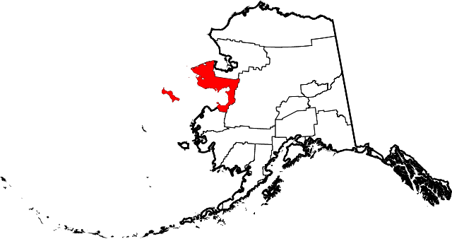
English: This is a locator map showing
Nome Census Area in Alaska |
| Date | |
| Source |
Own work: English: The maps use data from
nationalatlas.gov, specifically
countyp020.tar.gz on the
Raw Data Download page. The maps also use state outline data from
statesp020.tar.gz. The Florida maps use
hydrogm020.tar.gz to display Lake Okeechobee. |
| Author | David Benbennick |
Licensing
| I, the copyright holder of this work, release this work into the
public domain. This applies worldwide. In some countries this may not be legally possible; if so: I grant anyone the right to use this work for any purpose, without any conditions, unless such conditions are required by law. |
File history
Click on a date/time to view the file as it appeared at that time.
| Date/Time | Thumbnail | Dimensions | User | Comment | |
|---|---|---|---|---|---|
| current | 19:28, 5 March 2006 |
| 1,470 × 777 (338 KB) | David Benbennick | {{subst:User:Dbenbenn/clm|county=Nome Census Area|state=Alaska|type=borough and census area}} |
File usage
More than 100 pages use this file. The following list shows the first 100 pages that use this file only. A full list is available.
- Andreafsky Wilderness
- Anvil City Science Academy
- Arctic River
- Army Peak
- Besboro Island
- Bluff, Alaska
- Bonanza River
- Brevig Mission, Alaska
- Bureau of Indian Affairs Unalakleet School
- Cape Denbigh
- Cape Nome Roadhouse
- Cape Prince of Wales
- Council, Alaska
- Council Airport
- Demon Creek
- Devil Mountain (Alaska)
- Dickson, Alaska
- Diomede, Alaska (town)
- Discovery Saloon
- Eldorado River
- Elim, Alaska
- Flambeau River (Alaska)
- Fort Davis, Alaska
- Fort St. Michael
- Gambell, Alaska
- Gambell Sites
- Golovin, Alaska
- Granite Mountain Air Station
- Haycock, Alaska
- Haycock Airport
- Imuruk Basin
- Imuruk Lake volcanic field
- Iñupiat
- Jacob Berger House
- Kigluaik Mountains
- King Island (Alaska)
- Kookooligit Mountains
- Koyuk, Alaska
- Koyuk Alfred Adams Airport
- Kuzitrin River
- List of boroughs and census areas in Alaska
- Lopp Lagoon
- Lost Jim Lava Flow
- Lost River 1 Airport
- Mary's Igloo, Alaska
- Mint River
- Moses Point Army Airfield
- Mount Bendeleben
- Mount Osborn
- National Register of Historic Places listings in Nome Census Area, Alaska
- Nil Desperandum Gulch
- Niukluk River
- Nome, Alaska
- Nome Census Area, Alaska
- Nome–Teller Highway
- Norton Sound
- Nugnugaluktuk River
- Old St. Joseph's Catholic Church
- Pilgrim Hot Springs
- Port Clarence, Alaska
- Port Clarence Coast Guard Station
- Punuk Islands
- Sarichef Island
- Savoonga, Alaska
- Shaktoolik, Alaska
- Shaktoolik Airport
- Shishmaref, Alaska
- Shishmaref Inlet
- Sledge Island
- Snake River (Nome, Alaska)
- Solomon, Alaska
- Solomon Roadhouse
- St. Michael, Alaska
- St. Michael Airport
- St. Michael Island
- St. Michael volcanic field
- Stebbins, Alaska
- Stebbins Airport
- Stuart Island, Alaska
- Teller, Alaska
- Tin City, Alaska
- Unalakleet, Alaska
- Unalakleet Airport
- Unorganized Borough, Alaska
- Wales, Alaska
- Wales Airport (Alaska)
- Western Arctic National Parklands
- White Mountain, Alaska
- White Mountain Airport
- York, Alaska
- York Mountains
- Yupiit Piciryarait Cultural Center
- User:AridCeption/sandbox
- User:Nyttend/County templates/AK
- Wikipedia:WikiProject Alaska
- File talk:Map of Alaska highlighting Nome Census Area.svg
- Template:NomeAK-geo-stub
- Template:Nome Census Area, Alaska
- Template:Unorganized Borough, Alaska
- Category:Populated places in Nome Census Area, Alaska
View more links to this file.
Global file usage
The following other wikis use this file:
- Usage on az.wikipedia.org
- Usage on bpy.wikipedia.org
- Usage on ca.wikipedia.org
- Brevig Mission
- Diomede
- Elim (Alaska)
- Gambell
- Golovin
- Koyuk
- Nome (Alaska)
- Port Clarence
- Savoonga
- Shaktoolik
- Shishmaref
- St. Michael (Alaska)
- Stebbins
- Teller (Alaska)
- Unalakleet
- Wales (Alaska)
- White Mountain
- Llista de boroughs i àrees censals d'Alaska
- Plantilla:Àrea censal de Nome
- Categoria:Àrea censal de Nome
- Usage on ce.wikipedia.org
- Usage on cy.wikipedia.org
- Usage on de.wikipedia.org
- Usage on es.wikipedia.org
- Usage on fi.wikipedia.org
- Usage on fr.wikipedia.org
View more global usage of this file.