Size of this preview:
706 × 600 pixels. Other resolutions:
283 × 240 pixels |
565 × 480 pixels |
904 × 768 pixels |
1,206 × 1,024 pixels |
1,280 × 1,087 pixels.
Original file (1,280 × 1,087 pixels, file size: 33 KB, MIME type: image/png)
| This is a file from the
Wikimedia Commons. Information from its
description page there is shown below. Commons is a freely licensed media file repository. You can help. |
Summary
| Description |
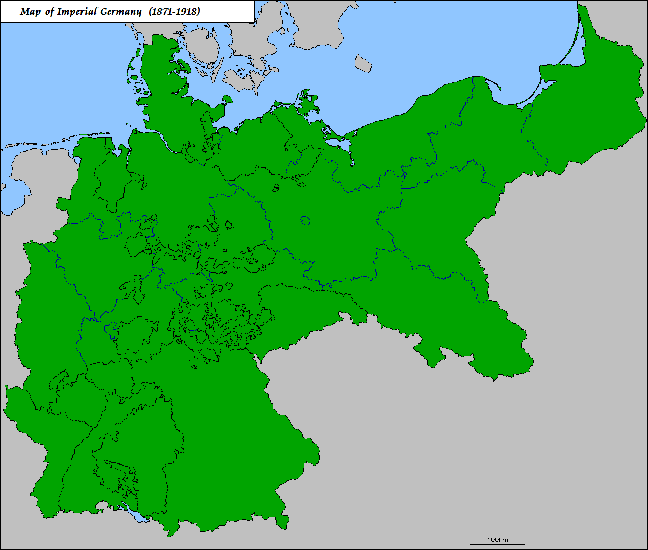
English: Map of the
German Empire, 1871-1918, showing its individual states and the provinces of Prussia
Deutsch: Karte des
Deutschen Kaiserreichs, 1871-1918, zeigt die einzelnen Staaten und Provinzen Preußens
Español: Mapa de la
Imperio alemán, 1871-1918, mostrando sus distintos estados y las provincias de Prusia |
| Date | Unknown date |
| Source | Own work |
| Author | Maps & Lucy and others |
Licensing

|
Permission is granted to copy, distribute and/or modify this document under the terms of the GNU Free Documentation License, Version 1.2 or any later version published by the Free Software Foundation; with no Invariant Sections, no Front-Cover Texts, and no Back-Cover Texts. A copy of the license is included in the section entitled GNU Free Documentation License. |
| This file is licensed under the Creative Commons Attribution-Share Alike 3.0 Unported license. | ||
| ||
| This licensing tag was added to this file as part of the GFDL licensing update. |
File history
Click on a date/time to view the file as it appeared at that time.
| Date/Time | Thumbnail | Dimensions | User | Comment | |
|---|---|---|---|---|---|
| current | 16:23, 16 April 2011 |
| 1,280 × 1,087 (33 KB) | Trockennasenaffe | optimized with OptiPNG |
| 21:01, 14 May 2010 |
 | 1,280 × 1,087 (82 KB) | Maps & Lucy | Clearer version with completely accurate depictions of the states of Imperial Germany and the imperial provinces of the Kingdom of Prussia | |
| 12:21, 14 January 2006 |
 | 1,200 × 1,015 (22 KB) | Rosenzweig | corrected version (some islands marked green are actually Dutch) | |
| 11:40, 1 March 2005 |
 | 1,200 × 1,015 (27 KB) | Openmindeduser | Map of the German Empire (Deutsches Kaiserreich), 1871-1918 |
File usage
The following pages on the English Wikipedia use this file (pages on other projects are not listed):
- User:A0231050705
- User:Addison Yen
- User:Alam567
- User:Andypiperuk
- User:AstralDrag0n27
- User:Basler04/GE
- User:BigHaz
- User:Brizius
- User:Canaen/German Empire
- User:CarolingianCitizen
- User:Central Data Bank
- User:Chariotsacha
- User:Coningsby
- User:Crimefighter1991
- User:DJ Rome
- User:Dainomite
- User:Dainomite/ubx/random
- User:Dcraig9
- User:Der Mensch
- User:Digital inf3rno
- User:Dubito, ergo cogito, ergo sum
- User:Eagle Fly5
- User:EarlGrey2005
- User:EmperorTab
- User:EntropicDisophan
- User:F McGady
- User:Falcaorib/Germany and Prussia
- User:Flemmish Nietzsche
- User:Flemmish Nietzsche/more
- User:FrederickII
- User:Gedditor
- User:Gunshot123
- User:Guy141
- User:Gyalu22
- User:Haru-tan
- User:Historyinc
- User:Hàlian
- User:Invisiblytouched
- User:ItemCo16527
- User:James H. Jenkins
- User:JandK87
- User:JeBonSer/Userboxes
- User:Jenkinsmanor
- User:JohnAntonacci
- User:K1ausMouse
- User:Kaiser Taylor
- User:Kaiser Taylor/Imperial Germany
- User:Kenotaph
- User:Kiwichris
- User:Kolya1927
- User:Koneijn de Ruyter/sandbox
- User:LazyExtrovert
- User:LockTightLobster
- User:LouisAragon
- User:Marcus Napoleon Ceasar
- User:Michaelino90
- User:Milesbroke
- User:Monsieurdl
- User:Mr.Lovecraft
- User:Mr. UnderhiIl
- User:Mruserbox
- User:Nikhilmn2002
- User:Odinson82
- User:Ph1ne4s
- User:Queenofinfinitespace
- User:RadManCF
- User:ReneAjax
- User:Saukkomies/My userboxes
- User:Sc135
- User:Sca/sandbox II
- User:Schwarzenbergika
- User:Sewati
- User:Srpbm
- User:SuperSkaterDude45
- User:Sxebill
- User:The Anonymous Gaul
- User:Thornfield Hall
- User:Vamsi20
- User:Vasko Kelich
- User:Veni, vidi, vici
- User:Victorfri~enwiki
- User:Volker89
- User:Vseruq
- User:Wateryloui22
- User:Yongbyong38
- User:Zimmarod
- User:ZorićVukašin
- User:חובבהיסטוריה
- Wikipedia:Userboxes/History/Empires
Global file usage
The following other wikis use this file:
- Usage on bg.wikipedia.org
- Usage on ca.wikipedia.org
- Usage on da.wikipedia.org
- Usage on de.wikipedia.org
- Usage on es.wikipedia.org
- Usage on et.wikipedia.org
- Usage on eu.wikipedia.org
- Usage on fr.wikipedia.org
- Usage on gl.wikipedia.org
- Usage on he.wikipedia.org
- Usage on hi.wikipedia.org
- Usage on hr.wikipedia.org
- Usage on kaa.wikipedia.org
- Usage on mk.wikipedia.org
- Usage on mzn.wikipedia.org
- Usage on no.wikipedia.org
- Usage on pcd.wikipedia.org
- Usage on pnb.wikipedia.org
- Usage on pt.wikipedia.org
- Usage on ro.wikipedia.org
- Usage on simple.wikipedia.org
- Usage on tr.wikipedia.org
- Usage on uk.wikipedia.org
- Usage on ur.wikipedia.org
- Usage on uz.wikipedia.org
Size of this preview:
706 × 600 pixels. Other resolutions:
283 × 240 pixels |
565 × 480 pixels |
904 × 768 pixels |
1,206 × 1,024 pixels |
1,280 × 1,087 pixels.
Original file (1,280 × 1,087 pixels, file size: 33 KB, MIME type: image/png)
| This is a file from the
Wikimedia Commons. Information from its
description page there is shown below. Commons is a freely licensed media file repository. You can help. |
Summary
| Description |
English: Map of the
German Empire, 1871-1918, showing its individual states and the provinces of Prussia
Deutsch: Karte des
Deutschen Kaiserreichs, 1871-1918, zeigt die einzelnen Staaten und Provinzen Preußens
Español: Mapa de la
Imperio alemán, 1871-1918, mostrando sus distintos estados y las provincias de Prusia |
| Date | Unknown date |
| Source | Own work |
| Author | Maps & Lucy and others |
Licensing
|
|
Permission is granted to copy, distribute and/or modify this document under the terms of the GNU Free Documentation License, Version 1.2 or any later version published by the Free Software Foundation; with no Invariant Sections, no Front-Cover Texts, and no Back-Cover Texts. A copy of the license is included in the section entitled GNU Free Documentation License. |
| This file is licensed under the Creative Commons Attribution-Share Alike 3.0 Unported license. | ||
| ||
| This licensing tag was added to this file as part of the GFDL licensing update. |
File history
Click on a date/time to view the file as it appeared at that time.
| Date/Time | Thumbnail | Dimensions | User | Comment | |
|---|---|---|---|---|---|
| current | 16:23, 16 April 2011 |
| 1,280 × 1,087 (33 KB) | Trockennasenaffe | optimized with OptiPNG |
| 21:01, 14 May 2010 |
| 1,280 × 1,087 (82 KB) | Maps & Lucy | Clearer version with completely accurate depictions of the states of Imperial Germany and the imperial provinces of the Kingdom of Prussia | |
| 12:21, 14 January 2006 |
| 1,200 × 1,015 (22 KB) | Rosenzweig | corrected version (some islands marked green are actually Dutch) | |
| 11:40, 1 March 2005 |
| 1,200 × 1,015 (27 KB) | Openmindeduser | Map of the German Empire (Deutsches Kaiserreich), 1871-1918 |
File usage
The following pages on the English Wikipedia use this file (pages on other projects are not listed):
- User:A0231050705
- User:Addison Yen
- User:Alam567
- User:Andypiperuk
- User:AstralDrag0n27
- User:Basler04/GE
- User:BigHaz
- User:Brizius
- User:Canaen/German Empire
- User:CarolingianCitizen
- User:Central Data Bank
- User:Chariotsacha
- User:Coningsby
- User:Crimefighter1991
- User:DJ Rome
- User:Dainomite
- User:Dainomite/ubx/random
- User:Dcraig9
- User:Der Mensch
- User:Digital inf3rno
- User:Dubito, ergo cogito, ergo sum
- User:Eagle Fly5
- User:EarlGrey2005
- User:EmperorTab
- User:EntropicDisophan
- User:F McGady
- User:Falcaorib/Germany and Prussia
- User:Flemmish Nietzsche
- User:Flemmish Nietzsche/more
- User:FrederickII
- User:Gedditor
- User:Gunshot123
- User:Guy141
- User:Gyalu22
- User:Haru-tan
- User:Historyinc
- User:Hàlian
- User:Invisiblytouched
- User:ItemCo16527
- User:James H. Jenkins
- User:JandK87
- User:JeBonSer/Userboxes
- User:Jenkinsmanor
- User:JohnAntonacci
- User:K1ausMouse
- User:Kaiser Taylor
- User:Kaiser Taylor/Imperial Germany
- User:Kenotaph
- User:Kiwichris
- User:Kolya1927
- User:Koneijn de Ruyter/sandbox
- User:LazyExtrovert
- User:LockTightLobster
- User:LouisAragon
- User:Marcus Napoleon Ceasar
- User:Michaelino90
- User:Milesbroke
- User:Monsieurdl
- User:Mr.Lovecraft
- User:Mr. UnderhiIl
- User:Mruserbox
- User:Nikhilmn2002
- User:Odinson82
- User:Ph1ne4s
- User:Queenofinfinitespace
- User:RadManCF
- User:ReneAjax
- User:Saukkomies/My userboxes
- User:Sc135
- User:Sca/sandbox II
- User:Schwarzenbergika
- User:Sewati
- User:Srpbm
- User:SuperSkaterDude45
- User:Sxebill
- User:The Anonymous Gaul
- User:Thornfield Hall
- User:Vamsi20
- User:Vasko Kelich
- User:Veni, vidi, vici
- User:Victorfri~enwiki
- User:Volker89
- User:Vseruq
- User:Wateryloui22
- User:Yongbyong38
- User:Zimmarod
- User:ZorićVukašin
- User:חובבהיסטוריה
- Wikipedia:Userboxes/History/Empires
Global file usage
The following other wikis use this file:
- Usage on bg.wikipedia.org
- Usage on ca.wikipedia.org
- Usage on da.wikipedia.org
- Usage on de.wikipedia.org
- Usage on es.wikipedia.org
- Usage on et.wikipedia.org
- Usage on eu.wikipedia.org
- Usage on fr.wikipedia.org
- Usage on gl.wikipedia.org
- Usage on he.wikipedia.org
- Usage on hi.wikipedia.org
- Usage on hr.wikipedia.org
- Usage on kaa.wikipedia.org
- Usage on mk.wikipedia.org
- Usage on mzn.wikipedia.org
- Usage on no.wikipedia.org
- Usage on pcd.wikipedia.org
- Usage on pnb.wikipedia.org
- Usage on pt.wikipedia.org
- Usage on ro.wikipedia.org
- Usage on simple.wikipedia.org
- Usage on tr.wikipedia.org
- Usage on uk.wikipedia.org
- Usage on ur.wikipedia.org
- Usage on uz.wikipedia.org