No higher resolution available.
Map-Aire_Gap_North-England.png (705 × 548 pixels, file size: 108 KB, MIME type: image/png)
| This is a file from the
Wikimedia Commons. Information from its
description page there is shown below. Commons is a freely licensed media file repository. You can help. |
Summary
| Description |
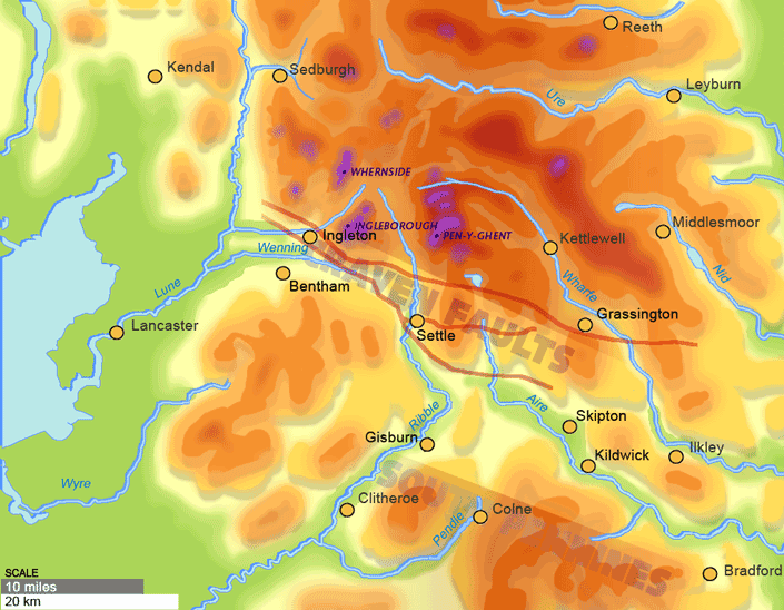
English: The Aire Gap lies between the Craven Fault and the limestone uplands of the Yorkshire Dales and the Forest of Bowland and the millstone grit moors of the South Pennines |
| Date | |
| Source | Own work ( Kildwyke) |
| Author | David Kidd |
54°0′0″N 2°10′0″W
Licensing
I, the copyright holder of this work, hereby publish it under the following licenses:
This file is licensed under the
Creative Commons
Attribution-Share Alike 3.0 Unported license.
- You are free:
- to share – to copy, distribute and transmit the work
- to remix – to adapt the work
- Under the following conditions:
- attribution – You must give appropriate credit, provide a link to the license, and indicate if changes were made. You may do so in any reasonable manner, but not in any way that suggests the licensor endorses you or your use.
- share alike – If you remix, transform, or build upon the material, you must distribute your contributions under the same or compatible license as the original.

|
Permission is granted to copy, distribute and/or modify this document under the terms of the GNU Free Documentation License, Version 1.2 or any later version published by the Free Software Foundation; with no Invariant Sections, no Front-Cover Texts, and no Back-Cover Texts. A copy of the license is included in the section entitled GNU Free Documentation License. |
You may select the license of your choice.
File history
Click on a date/time to view the file as it appeared at that time.
| Date/Time | Thumbnail | Dimensions | User | Comment | |
|---|---|---|---|---|---|
| current | 14:19, 12 August 2011 |
| 705 × 548 (108 KB) | JD554 | cropped to remove credit |
| 14:12, 8 August 2011 |
 | 720 × 548 (110 KB) | Kildwyke | {{Information |Description ={{en|1=The Aire Gap lies between the Craven Fault and the limestone uplands of the Yorkshire Dales and the Forest of Bowland and the millstone grit moors of the South Pennines}} |Source ={{own}} |Author =[[Us |
File usage
The following pages on the English Wikipedia use this file (pages on other projects are not listed):
No higher resolution available.
Map-Aire_Gap_North-England.png (705 × 548 pixels, file size: 108 KB, MIME type: image/png)
| This is a file from the
Wikimedia Commons. Information from its
description page there is shown below. Commons is a freely licensed media file repository. You can help. |
Summary
| Description |
English: The Aire Gap lies between the Craven Fault and the limestone uplands of the Yorkshire Dales and the Forest of Bowland and the millstone grit moors of the South Pennines |
| Date | |
| Source | Own work ( Kildwyke) |
| Author | David Kidd |
54°0′0″N 2°10′0″W
Licensing
I, the copyright holder of this work, hereby publish it under the following licenses:
This file is licensed under the
Creative Commons
Attribution-Share Alike 3.0 Unported license.
- You are free:
- to share – to copy, distribute and transmit the work
- to remix – to adapt the work
- Under the following conditions:
- attribution – You must give appropriate credit, provide a link to the license, and indicate if changes were made. You may do so in any reasonable manner, but not in any way that suggests the licensor endorses you or your use.
- share alike – If you remix, transform, or build upon the material, you must distribute your contributions under the same or compatible license as the original.
|
|
Permission is granted to copy, distribute and/or modify this document under the terms of the GNU Free Documentation License, Version 1.2 or any later version published by the Free Software Foundation; with no Invariant Sections, no Front-Cover Texts, and no Back-Cover Texts. A copy of the license is included in the section entitled GNU Free Documentation License. |
You may select the license of your choice.
File history
Click on a date/time to view the file as it appeared at that time.
| Date/Time | Thumbnail | Dimensions | User | Comment | |
|---|---|---|---|---|---|
| current | 14:19, 12 August 2011 |
| 705 × 548 (108 KB) | JD554 | cropped to remove credit |
| 14:12, 8 August 2011 |
| 720 × 548 (110 KB) | Kildwyke | {{Information |Description ={{en|1=The Aire Gap lies between the Craven Fault and the limestone uplands of the Yorkshire Dales and the Forest of Bowland and the millstone grit moors of the South Pennines}} |Source ={{own}} |Author =[[Us |
File usage
The following pages on the English Wikipedia use this file (pages on other projects are not listed):