
Size of this preview:
800 × 590 pixels. Other resolutions:
320 × 236 pixels |
640 × 472 pixels |
1,024 × 755 pixels |
1,280 × 944 pixels |
2,560 × 1,888 pixels |
3,024 × 2,230 pixels.
Original file (3,024 × 2,230 pixels, file size: 12.51 MB, MIME type: image/png)
| This is a file from the
Wikimedia Commons. Information from its
description page there is shown below. Commons is a freely licensed media file repository. You can help. |
Summary
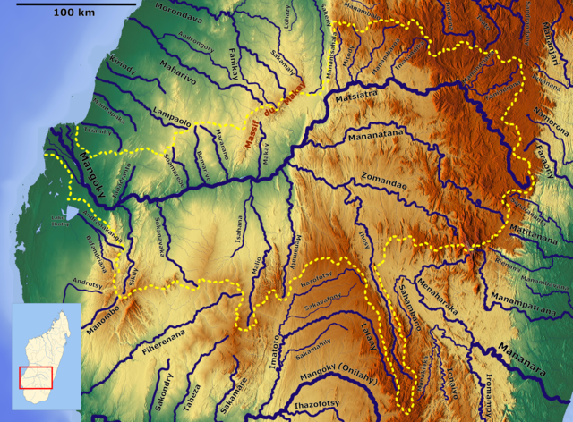
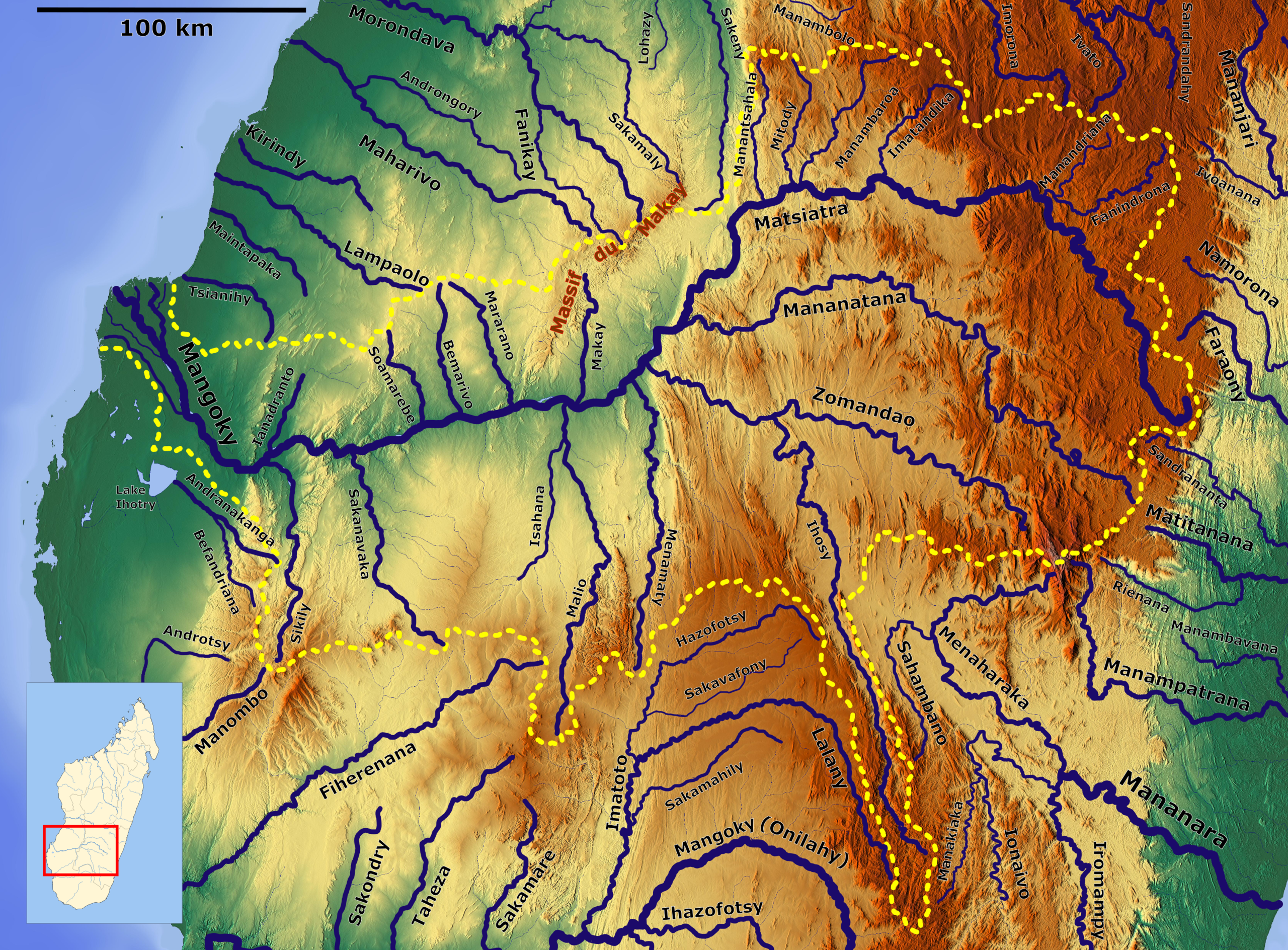
| Description | Mangoky Basin_OSM. Based on US military map Se-SF38-39 |
| Date | |
| Source | https://maps-for-free.com, http://legacy.lib.utexas.edu/maps/ams/africa_1m/, Location map: File:Madagascar location map.svg |
| Author | Hans Braxmeier & Peter in s, Location map: NordNordWest |
This file is licensed under the
Creative Commons
Attribution-Share Alike 3.0 Unported license.
- You are free:
- to share – to copy, distribute and transmit the work
- to remix – to adapt the work
- Under the following conditions:
- attribution – You must give appropriate credit, provide a link to the license, and indicate if changes were made. You may do so in any reasonable manner, but not in any way that suggests the licensor endorses you or your use.
- share alike – If you remix, transform, or build upon the material, you must distribute your contributions under the same or compatible license as the original.
File history
Click on a date/time to view the file as it appeared at that time.
| Date/Time | Thumbnail | Dimensions | User | Comment | |
|---|---|---|---|---|---|
| current | 07:05, 1 April 2021 |
| 3,024 × 2,230 (12.51 MB) | Peter in s | {{Information |Description= Mangoky Basin_OSM. Based on US military map Se-SF38-39 |Source= https://maps-for-free.com, http://legacy.lib.utexas.edu/maps/ams/africa_1m/ |Date= 2021-04-01 |Author= Hans Braxmeier & Peter in s |Permission= |other_versions= }} {{cc-by-sa-2.0}} Category:Mangoky Category:Maps of rivers of Madagascar Category:Drainage basin maps of Africa |
File usage
The following pages on the English Wikipedia use this file (pages on other projects are not listed):
Global file usage
The following other wikis use this file:
- Usage on de.wikipedia.org
- Usage on ff.wikipedia.org
- Usage on fr.wikipedia.org
- Usage on ha.wikipedia.org
- Usage on ro.wikipedia.org
- Usage on sl.wikipedia.org
Metadata
Size of this preview:
800 × 590 pixels. Other resolutions:
320 × 236 pixels |
640 × 472 pixels |
1,024 × 755 pixels |
1,280 × 944 pixels |
2,560 × 1,888 pixels |
3,024 × 2,230 pixels.
Original file (3,024 × 2,230 pixels, file size: 12.51 MB, MIME type: image/png)
| This is a file from the
Wikimedia Commons. Information from its
description page there is shown below. Commons is a freely licensed media file repository. You can help. |
Summary
| Description | Mangoky Basin_OSM. Based on US military map Se-SF38-39 |
| Date | |
| Source | https://maps-for-free.com, http://legacy.lib.utexas.edu/maps/ams/africa_1m/, Location map: File:Madagascar location map.svg |
| Author | Hans Braxmeier & Peter in s, Location map: NordNordWest |
This file is licensed under the
Creative Commons
Attribution-Share Alike 3.0 Unported license.
- You are free:
- to share – to copy, distribute and transmit the work
- to remix – to adapt the work
- Under the following conditions:
- attribution – You must give appropriate credit, provide a link to the license, and indicate if changes were made. You may do so in any reasonable manner, but not in any way that suggests the licensor endorses you or your use.
- share alike – If you remix, transform, or build upon the material, you must distribute your contributions under the same or compatible license as the original.
File history
Click on a date/time to view the file as it appeared at that time.
| Date/Time | Thumbnail | Dimensions | User | Comment | |
|---|---|---|---|---|---|
| current | 07:05, 1 April 2021 |
| 3,024 × 2,230 (12.51 MB) | Peter in s | {{Information |Description= Mangoky Basin_OSM. Based on US military map Se-SF38-39 |Source= https://maps-for-free.com, http://legacy.lib.utexas.edu/maps/ams/africa_1m/ |Date= 2021-04-01 |Author= Hans Braxmeier & Peter in s |Permission= |other_versions= }} {{cc-by-sa-2.0}} Category:Mangoky Category:Maps of rivers of Madagascar Category:Drainage basin maps of Africa |
File usage
The following pages on the English Wikipedia use this file (pages on other projects are not listed):
Global file usage
The following other wikis use this file:
- Usage on de.wikipedia.org
- Usage on ff.wikipedia.org
- Usage on fr.wikipedia.org
- Usage on ha.wikipedia.org
- Usage on ro.wikipedia.org
- Usage on sl.wikipedia.org