Photos • Location


Size of this preview:
800 × 449 pixels. Other resolutions:
320 × 180 pixels |
640 × 359 pixels |
1,024 × 574 pixels |
1,280 × 718 pixels |
2,560 × 1,436 pixels |
4,592 × 2,576 pixels.
Original file (4,592 × 2,576 pixels, file size: 5.75 MB, MIME type: image/jpeg)
| This is a file from the
Wikimedia Commons. Information from its
description page there is shown below. Commons is a freely licensed media file repository. You can help. |
Summary
| Camera location |
| View this and other nearby images on: OpenStreetMap |
|
|---|
| Description |
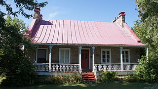
Français : La valeur patrimoniale de la maison Abraham-Dubois repose sur son intérêt architectural. Cette habitation est construite vers 1800. Elle est représentative de la maison rurale d'inspiration française par son corps de logis massif en maçonnerie de pierre calcaire grossièrement équarrie. Source: Ville de Boisbriand 2008 English: The patrimonial value of the Abraham-Dubois house rests on its architectural interest. This house was built around 1800. It is representative of the rural house of French inspiration by its massive main building in masonry of crudely squared limestone. Source: City of Boisbriand 2008
|
This photo is of a
cultural heritage site in Canada, number
9638
|
|
| Date | |
| Source | Own work |
| Author | Hadrianopolis |
Licensing
I, the copyright holder of this work, hereby publish it under the following license:
This file is licensed under the
Creative Commons
Attribution-Share Alike 3.0 Unported license.
- You are free:
- to share – to copy, distribute and transmit the work
- to remix – to adapt the work
- Under the following conditions:
- attribution – You must give appropriate credit, provide a link to the license, and indicate if changes were made. You may do so in any reasonable manner, but not in any way that suggests the licensor endorses you or your use.
- share alike – If you remix, transform, or build upon the material, you must distribute your contributions under the same or compatible license as the original.

|
This image was uploaded as part of
Wiki Loves Monuments 2012.
|
File history
Click on a date/time to view the file as it appeared at that time.
| Date/Time | Thumbnail | Dimensions | User | Comment | |
|---|---|---|---|---|---|
| current | 19:50, 3 September 2012 |
| 4,592 × 2,576 (5.75 MB) | Hadrianopolis | User created page with UploadWizard |
File usage
The following pages on the English Wikipedia use this file (pages on other projects are not listed):
Global file usage
The following other wikis use this file:
- Usage on fr.wikipedia.org
- Usage on www.wikidata.org
Metadata
Size of this preview:
800 × 449 pixels. Other resolutions:
320 × 180 pixels |
640 × 359 pixels |
1,024 × 574 pixels |
1,280 × 718 pixels |
2,560 × 1,436 pixels |
4,592 × 2,576 pixels.
Original file (4,592 × 2,576 pixels, file size: 5.75 MB, MIME type: image/jpeg)
| This is a file from the
Wikimedia Commons. Information from its
description page there is shown below. Commons is a freely licensed media file repository. You can help. |
Summary
| Camera location |
| View this and other nearby images on: OpenStreetMap |
|
|---|
| Description |
Français : La valeur patrimoniale de la maison Abraham-Dubois repose sur son intérêt architectural. Cette habitation est construite vers 1800. Elle est représentative de la maison rurale d'inspiration française par son corps de logis massif en maçonnerie de pierre calcaire grossièrement équarrie. Source: Ville de Boisbriand 2008 English: The patrimonial value of the Abraham-Dubois house rests on its architectural interest. This house was built around 1800. It is representative of the rural house of French inspiration by its massive main building in masonry of crudely squared limestone. Source: City of Boisbriand 2008
|
This photo is of a
cultural heritage site in Canada, number
9638
|
|
| Date | |
| Source | Own work |
| Author | Hadrianopolis |
Licensing
I, the copyright holder of this work, hereby publish it under the following license:
This file is licensed under the
Creative Commons
Attribution-Share Alike 3.0 Unported license.
- You are free:
- to share – to copy, distribute and transmit the work
- to remix – to adapt the work
- Under the following conditions:
- attribution – You must give appropriate credit, provide a link to the license, and indicate if changes were made. You may do so in any reasonable manner, but not in any way that suggests the licensor endorses you or your use.
- share alike – If you remix, transform, or build upon the material, you must distribute your contributions under the same or compatible license as the original.
|
|
This image was uploaded as part of
Wiki Loves Monuments 2012.
|
File history
Click on a date/time to view the file as it appeared at that time.
| Date/Time | Thumbnail | Dimensions | User | Comment | |
|---|---|---|---|---|---|
| current | 19:50, 3 September 2012 |
| 4,592 × 2,576 (5.75 MB) | Hadrianopolis | User created page with UploadWizard |
File usage
The following pages on the English Wikipedia use this file (pages on other projects are not listed):
Global file usage
The following other wikis use this file:
- Usage on fr.wikipedia.org
- Usage on www.wikidata.org