
Original file (SVG file, nominally 426 × 774 pixels, file size: 2.2 MB)
| This is a file from the
Wikimedia Commons. Information from its
description page there is shown below. Commons is a freely licensed media file repository. You can help. |
Summary
| Description |
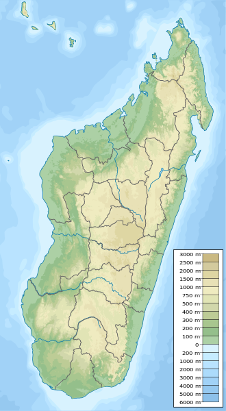
English: Physical map of Madagascar, parameters equal to
Madagascar location map.svg. |
| Date | |
| Source | Own work |
| Author | Urutseg |
| SVG development |
Licensing
| I, the copyright holder of this work, release this work into the
public domain. This applies worldwide. In some countries this may not be legally possible; if so: I grant anyone the right to use this work for any purpose, without any conditions, unless such conditions are required by law. |
File history
Click on a date/time to view the file as it appeared at that time.
| Date/Time | Thumbnail | Dimensions | User | Comment | |
|---|---|---|---|---|---|
| current | 23:09, 12 May 2023 |
| 426 × 774 (2.2 MB) | GrandEscogriffe | adding two region borders: Atsinanana/Analanjirofo and Vatovavy-Fitovinany |
| 19:02, 11 October 2013 |
 | 426 × 774 (2.17 MB) | NordNordWest | upd | |
| 19:26, 13 February 2011 |
 | 426 × 774 (2.76 MB) | Urutseg | {{Information |Description ={{en|1=Physical map of Madagascar, parameters equal to File:Madagascar location map.svg.}} |Source ={{own}} |Author = Urutseg |Date =2011-02-13 |Permission = |other_version |
File usage
More than 100 pages use this file. The following list shows the first 100 pages that use this file only. A full list is available.
- Amber Forest Reserve
- Ambohimanga
- Ambohitantely Special Reserve
- Ambolafotsy Formation
- Analamazaotra National Park
- Analamerana Special Reserve
- Andasibe-Mantadia National Park
- Andekaleka Dam
- Andohahela National Park
- Andranomena Special Reserve
- Andriamamovoka Falls
- Andringitra National Park
- Anjanaharibe-Sud Special Reserve
- Anjobony
- Ankarafantsika Formation
- Ankarafantsika National Park
- Ankarana Special Reserve
- Ankazomihaboka Formation
- Ankeniheny-Zahamena Corridor
- Antananarivo
- Antongil Bay
- Antsiranana Bay
- Battle of Tamatave
- Bay of Langarano
- Bay of Saint-Augustin
- Bemaraha Formation
- Bemarivo (Sofia)
- Bemarivo Special Reserve
- Berivotra Formation
- Betampona Reserve
- Beza Mahafaly Special Reserve
- Bora Special Reserve
- Cape Sainte Marie
- Hatokaliotsy Special Reserve
- Humbert Falls
- Isalo II
- Isalo III Formation
- James Plaintain
- Kalambatritra Special Reserve
- Kandreho Formation
- Kasijy Special Reserve
- Lake Alaotra
- Lake Anosy
- Lake Ihotry
- Lake Kinkony
- Lake Mandraka
- Lake Mantasoa
- Lake Tritriva
- Lake Tsimanampetsotsa
- List of World Heritage Sites in Madagascar
- List of fossiliferous stratigraphic units in Madagascar
- Maevarano Formation
- Mahamanina Falls
- Mahavavy-Kinkony
- Makira Natural Park
- Mananara-Nord National Park
- Mandraka Dam
- Mandraka Falls
- Mangerivola Special Reserve
- Maningoza Special Reserve
- Manombo Special Reserve
- Manongarivo Special Reserve
- Mantasoa Dam
- Marojejy National Park
- Marolambo National Park
- Maromokotro
- Marotandrano Special Reserve
- Menabe Antimena
- Midongy du sud National Park
- Mikea National Park
- Montagne d'Ambre National Park
- Montagne des Français
- Mount Ambohitra
- Mount Tsiafajavona
- Nosy Berafia
- Nosy Faly
- Nosy Mangabe
- Nosy Tanihely National Park
- Nosy Tsarabanjina
- Nosy Ve-Androka National Park
- Pic d'Ivohibe Reserve
- Rainforests of the Atsinanana
- Rianbavy Falls
- Riandahy Falls
- Sainte Luce Reserve
- Sakaleona Falls
- Tampoketsa Analamaitso Reserve
- Tsaratanana Reserve
- Tsiazompaniry Dam
- Tsimanampetsotsa National Park
- Tsimiroro
- Tsingy de Bemaraha National Park
- Tsingy de Bemaraha Strict Nature Reserve
- Tsingy de Namoroka National Park
- Tsitongambarika
- Whaling in Madagascar
- Zahamena National Park
- User:GerardM/Communes of Madagascar
- User:Ty654/List of earthquakes from 1950-1954 exceeding magnitude 6+
- Wikipedia:WikiProject WikiFundi Content/Ambohimanga
View more links to this file.
Global file usage
The following other wikis use this file:
- Usage on ar.wikipedia.org
- Usage on arz.wikipedia.org
- Usage on ast.wikipedia.org
- Usage on azb.wikipedia.org
- Usage on az.wikipedia.org
- Usage on ba.wikipedia.org
- Usage on be.wikipedia.org
- Usage on bg.wikipedia.org
- Антананариву
- Шаблон:ПК Мадагаскар
- Анцирабе
- Амбатулямпи
- Бетафо
- Анджома Рамартина
- Ранумафана (окръг Ифанадиана)
- Васиана
- Анказомириотра
- Инанантона
- Мандото
- Мандрицара (окръг Бетафо)
- Махаиза
- Тритрива
- Фидирана
- Соавина (окръг Бетафо)
- Амбалярану
- Белязау
- Амбухинапечака
- Анджануманеляча
- Миаринариву Бемулюлю
- Амбовомбе
- Usage on bn.wikipedia.org
- Usage on bs.wikipedia.org
- Usage on ca.wikipedia.org
- Usage on ceb.wikipedia.org
- Usage on ce.wikipedia.org
View more global usage of this file.
Metadata
Original file (SVG file, nominally 426 × 774 pixels, file size: 2.2 MB)
| This is a file from the
Wikimedia Commons. Information from its
description page there is shown below. Commons is a freely licensed media file repository. You can help. |
Summary
| Description |
English: Physical map of Madagascar, parameters equal to
Madagascar location map.svg. |
| Date | |
| Source | Own work |
| Author | Urutseg |
| SVG development |
Licensing
| I, the copyright holder of this work, release this work into the
public domain. This applies worldwide. In some countries this may not be legally possible; if so: I grant anyone the right to use this work for any purpose, without any conditions, unless such conditions are required by law. |
File history
Click on a date/time to view the file as it appeared at that time.
| Date/Time | Thumbnail | Dimensions | User | Comment | |
|---|---|---|---|---|---|
| current | 23:09, 12 May 2023 |
| 426 × 774 (2.2 MB) | GrandEscogriffe | adding two region borders: Atsinanana/Analanjirofo and Vatovavy-Fitovinany |
| 19:02, 11 October 2013 |
| 426 × 774 (2.17 MB) | NordNordWest | upd | |
| 19:26, 13 February 2011 |
| 426 × 774 (2.76 MB) | Urutseg | {{Information |Description ={{en|1=Physical map of Madagascar, parameters equal to File:Madagascar location map.svg.}} |Source ={{own}} |Author = Urutseg |Date =2011-02-13 |Permission = |other_version |
File usage
More than 100 pages use this file. The following list shows the first 100 pages that use this file only. A full list is available.
- Amber Forest Reserve
- Ambohimanga
- Ambohitantely Special Reserve
- Ambolafotsy Formation
- Analamazaotra National Park
- Analamerana Special Reserve
- Andasibe-Mantadia National Park
- Andekaleka Dam
- Andohahela National Park
- Andranomena Special Reserve
- Andriamamovoka Falls
- Andringitra National Park
- Anjanaharibe-Sud Special Reserve
- Anjobony
- Ankarafantsika Formation
- Ankarafantsika National Park
- Ankarana Special Reserve
- Ankazomihaboka Formation
- Ankeniheny-Zahamena Corridor
- Antananarivo
- Antongil Bay
- Antsiranana Bay
- Battle of Tamatave
- Bay of Langarano
- Bay of Saint-Augustin
- Bemaraha Formation
- Bemarivo (Sofia)
- Bemarivo Special Reserve
- Berivotra Formation
- Betampona Reserve
- Beza Mahafaly Special Reserve
- Bora Special Reserve
- Cape Sainte Marie
- Hatokaliotsy Special Reserve
- Humbert Falls
- Isalo II
- Isalo III Formation
- James Plaintain
- Kalambatritra Special Reserve
- Kandreho Formation
- Kasijy Special Reserve
- Lake Alaotra
- Lake Anosy
- Lake Ihotry
- Lake Kinkony
- Lake Mandraka
- Lake Mantasoa
- Lake Tritriva
- Lake Tsimanampetsotsa
- List of World Heritage Sites in Madagascar
- List of fossiliferous stratigraphic units in Madagascar
- Maevarano Formation
- Mahamanina Falls
- Mahavavy-Kinkony
- Makira Natural Park
- Mananara-Nord National Park
- Mandraka Dam
- Mandraka Falls
- Mangerivola Special Reserve
- Maningoza Special Reserve
- Manombo Special Reserve
- Manongarivo Special Reserve
- Mantasoa Dam
- Marojejy National Park
- Marolambo National Park
- Maromokotro
- Marotandrano Special Reserve
- Menabe Antimena
- Midongy du sud National Park
- Mikea National Park
- Montagne d'Ambre National Park
- Montagne des Français
- Mount Ambohitra
- Mount Tsiafajavona
- Nosy Berafia
- Nosy Faly
- Nosy Mangabe
- Nosy Tanihely National Park
- Nosy Tsarabanjina
- Nosy Ve-Androka National Park
- Pic d'Ivohibe Reserve
- Rainforests of the Atsinanana
- Rianbavy Falls
- Riandahy Falls
- Sainte Luce Reserve
- Sakaleona Falls
- Tampoketsa Analamaitso Reserve
- Tsaratanana Reserve
- Tsiazompaniry Dam
- Tsimanampetsotsa National Park
- Tsimiroro
- Tsingy de Bemaraha National Park
- Tsingy de Bemaraha Strict Nature Reserve
- Tsingy de Namoroka National Park
- Tsitongambarika
- Whaling in Madagascar
- Zahamena National Park
- User:GerardM/Communes of Madagascar
- User:Ty654/List of earthquakes from 1950-1954 exceeding magnitude 6+
- Wikipedia:WikiProject WikiFundi Content/Ambohimanga
View more links to this file.
Global file usage
The following other wikis use this file:
- Usage on ar.wikipedia.org
- Usage on arz.wikipedia.org
- Usage on ast.wikipedia.org
- Usage on azb.wikipedia.org
- Usage on az.wikipedia.org
- Usage on ba.wikipedia.org
- Usage on be.wikipedia.org
- Usage on bg.wikipedia.org
- Антананариву
- Шаблон:ПК Мадагаскар
- Анцирабе
- Амбатулямпи
- Бетафо
- Анджома Рамартина
- Ранумафана (окръг Ифанадиана)
- Васиана
- Анказомириотра
- Инанантона
- Мандото
- Мандрицара (окръг Бетафо)
- Махаиза
- Тритрива
- Фидирана
- Соавина (окръг Бетафо)
- Амбалярану
- Белязау
- Амбухинапечака
- Анджануманеляча
- Миаринариву Бемулюлю
- Амбовомбе
- Usage on bn.wikipedia.org
- Usage on bs.wikipedia.org
- Usage on ca.wikipedia.org
- Usage on ceb.wikipedia.org
- Usage on ce.wikipedia.org
View more global usage of this file.