
Size of this preview:
511 × 599 pixels. Other resolutions:
205 × 240 pixels |
409 × 480 pixels |
694 × 814 pixels.
Original file (694 × 814 pixels, file size: 615 KB, MIME type: image/gif, looped, 7 frames, 21 s)
| This is a file from the
Wikimedia Commons. Information from its
description page there is shown below. Commons is a freely licensed media file repository. You can help. |
| Description |
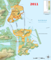
Français : Carte topographique et administrative en français de
Macao, avec l'évolution depuis l'arrivée des Portugais entre 1554 et 1557, jusqu'en 2004. Deutsch: Topographische Karte / Verwaltungskarte zum
Macao, in Französische English: Topographic and administrative map in French of
Macau Español: Mapa topográfico y administrativo en francès de
Macao Italiano: Carta topografica e amministrativa de
Macao 日本語: フランス語で表示した
マカオの地形·行政地図 Português: Carta topográfica e da administração do
Macau em francês |
||||
| Date | 05/10/2010 (10 mai 2010) | ||||
| Source |
Français : Création personnelle ;
English: Own work ;
|
||||
| Author | Bourrichon - fr:Bourrichon | ||||
| Permission ( Reusing this file) |
I, the copyright holder of this work, hereby publish it under the following licenses:
This file is licensed under the
Creative Commons Attribution-Share Alike
3.0 Unported,
2.5 Generic,
2.0 Generic and
1.0 Generic license.
You may select the license of your choice. |
||||
| Other versions |
|


File history
Click on a date/time to view the file as it appeared at that time.
| Date/Time | Thumbnail | Dimensions | User | Comment | |
|---|---|---|---|---|---|
| current | 08:56, 25 February 2011 |
| 694 × 814 (615 KB) | Bourrichon | petite correction |
| 20:13, 24 February 2011 |
 | 694 × 814 (615 KB) | Bourrichon | + petite extension portuaire | |
| 19:59, 24 February 2011 |
 | 694 × 814 (613 KB) | Bourrichon | Quelques corrections | |
| 19:38, 9 May 2010 |
 | 694 × 814 (610 KB) | Bourrichon | +2010 | |
| 17:23, 9 May 2010 |
 | 694 × 814 (506 KB) | Bourrichon | {{Information |Description= {{fr|Carte topographique et administrative en français de Macao, avec l'évolution depuis l'arrivée des Portugais entre 1554 et 1557.}}{{de|Topographische Karte / Verwaltungskarte zum Macao, in Fra |
File usage
The following pages on the English Wikipedia use this file (pages on other projects are not listed):
Global file usage
The following other wikis use this file:
- Usage on cs.wikipedia.org
- Usage on fr.wikipedia.org
- Usage on ja.wikipedia.org
- Usage on ru.wikipedia.org
- Usage on zh.wikipedia.org
Size of this preview:
511 × 599 pixels. Other resolutions:
205 × 240 pixels |
409 × 480 pixels |
694 × 814 pixels.
Original file (694 × 814 pixels, file size: 615 KB, MIME type: image/gif, looped, 7 frames, 21 s)
| This is a file from the
Wikimedia Commons. Information from its
description page there is shown below. Commons is a freely licensed media file repository. You can help. |
| Description |
Français : Carte topographique et administrative en français de
Macao, avec l'évolution depuis l'arrivée des Portugais entre 1554 et 1557, jusqu'en 2004. Deutsch: Topographische Karte / Verwaltungskarte zum
Macao, in Französische English: Topographic and administrative map in French of
Macau Español: Mapa topográfico y administrativo en francès de
Macao Italiano: Carta topografica e amministrativa de
Macao 日本語: フランス語で表示した
マカオの地形·行政地図 Português: Carta topográfica e da administração do
Macau em francês |
||||
| Date | 05/10/2010 (10 mai 2010) | ||||
| Source |
Français : Création personnelle ;
English: Own work ;
|
||||
| Author | Bourrichon - fr:Bourrichon | ||||
| Permission ( Reusing this file) |
I, the copyright holder of this work, hereby publish it under the following licenses:
This file is licensed under the
Creative Commons Attribution-Share Alike
3.0 Unported,
2.5 Generic,
2.0 Generic and
1.0 Generic license.
You may select the license of your choice. |
||||
| Other versions |
|
File history
Click on a date/time to view the file as it appeared at that time.
| Date/Time | Thumbnail | Dimensions | User | Comment | |
|---|---|---|---|---|---|
| current | 08:56, 25 February 2011 |
| 694 × 814 (615 KB) | Bourrichon | petite correction |
| 20:13, 24 February 2011 |
| 694 × 814 (615 KB) | Bourrichon | + petite extension portuaire | |
| 19:59, 24 February 2011 |
| 694 × 814 (613 KB) | Bourrichon | Quelques corrections | |
| 19:38, 9 May 2010 |
| 694 × 814 (610 KB) | Bourrichon | +2010 | |
| 17:23, 9 May 2010 |
| 694 × 814 (506 KB) | Bourrichon | {{Information |Description= {{fr|Carte topographique et administrative en français de Macao, avec l'évolution depuis l'arrivée des Portugais entre 1554 et 1557.}}{{de|Topographische Karte / Verwaltungskarte zum Macao, in Fra |
File usage
The following pages on the English Wikipedia use this file (pages on other projects are not listed):
Global file usage
The following other wikis use this file:
- Usage on cs.wikipedia.org
- Usage on fr.wikipedia.org
- Usage on ja.wikipedia.org
- Usage on ru.wikipedia.org
- Usage on zh.wikipedia.org