
Size of this preview:
275 × 600 pixels. Other resolutions:
110 × 240 pixels |
326 × 711 pixels.
Original file (326 × 711 pixels, file size: 12 KB, MIME type: image/png)
| This is a file from the
Wikimedia Commons. Information from its
description page there is shown below. Commons is a freely licensed media file repository. You can help. |
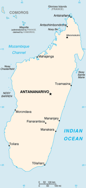
| Description | Map of Madagascar showing major cities. | |||
| Date | ||||
| Source | CIA, The World Factbook, 2004 | |||
| Author | CIA | |||
| Permission ( Reusing this file) |
|

File history
Click on a date/time to view the file as it appeared at that time.
| Date/Time | Thumbnail | Dimensions | User | Comment | |
|---|---|---|---|---|---|
| current | 05:26, 1 May 2010 |
| 326 × 711 (12 KB) | Ras67 | cropped |
| 18:02, 29 September 2006 |
 | 330 × 717 (13 KB) | Darkoneko | Rétablissement de la version précédente | |
| 13:39, 29 September 2006 |
 | 276 × 600 (18 KB) | Loveless | This image was copied from wikipedia:fr. The original description was: fr:mg:Image:Ma-map.png Carte de madagascar CIA worldfact book {{DomainePublic}} {| border="1" ! date/time || username || resolution || size || edit summary |---- | |} | |
| 20:14, 5 March 2005 |
 | 330 × 717 (13 KB) | Alfio | CIA map of Madagascar |
File usage
The following pages on the English Wikipedia use this file (pages on other projects are not listed):
Global file usage
The following other wikis use this file:
- Usage on als.wikipedia.org
- Usage on am.wikipedia.org
- Usage on ban.wikipedia.org
- Usage on bjn.wikipedia.org
- Usage on da.wikipedia.org
- Usage on de.wikipedia.org
- Usage on el.wikipedia.org
- Usage on en.wikisource.org
- Usage on eo.wikipedia.org
- Usage on es.wikipedia.org
- Usage on fi.wikipedia.org
- Usage on fi.wikivoyage.org
- Usage on fr.wikinews.org
- Usage on gl.wikipedia.org
- Usage on hu.wikipedia.org
- Usage on hu.wiktionary.org
- Usage on id.wikipedia.org
- Usage on it.wikipedia.org
- Usage on it.wikinews.org
- Usage on ja.wikipedia.org
- Usage on kn.wikipedia.org
- Usage on la.wikipedia.org
- Usage on lfn.wikipedia.org
- Usage on lt.wiktionary.org
- Usage on mg.wikipedia.org
- Usage on min.wikipedia.org
- Usage on ml.wikipedia.org
- Usage on mr.wikipedia.org
- Usage on nds.wikipedia.org
- Usage on nl.wikipedia.org
- Usage on nn.wikipedia.org
View more global usage of this file.
Size of this preview:
275 × 600 pixels. Other resolutions:
110 × 240 pixels |
326 × 711 pixels.
Original file (326 × 711 pixels, file size: 12 KB, MIME type: image/png)
| This is a file from the
Wikimedia Commons. Information from its
description page there is shown below. Commons is a freely licensed media file repository. You can help. |
| Description | Map of Madagascar showing major cities. | |||
| Date | ||||
| Source | CIA, The World Factbook, 2004 | |||
| Author | CIA | |||
| Permission ( Reusing this file) |
|
File history
Click on a date/time to view the file as it appeared at that time.
| Date/Time | Thumbnail | Dimensions | User | Comment | |
|---|---|---|---|---|---|
| current | 05:26, 1 May 2010 |
| 326 × 711 (12 KB) | Ras67 | cropped |
| 18:02, 29 September 2006 |
| 330 × 717 (13 KB) | Darkoneko | Rétablissement de la version précédente | |
| 13:39, 29 September 2006 |
| 276 × 600 (18 KB) | Loveless | This image was copied from wikipedia:fr. The original description was: fr:mg:Image:Ma-map.png Carte de madagascar CIA worldfact book {{DomainePublic}} {| border="1" ! date/time || username || resolution || size || edit summary |---- | |} | |
| 20:14, 5 March 2005 |
| 330 × 717 (13 KB) | Alfio | CIA map of Madagascar |
File usage
The following pages on the English Wikipedia use this file (pages on other projects are not listed):
Global file usage
The following other wikis use this file:
- Usage on als.wikipedia.org
- Usage on am.wikipedia.org
- Usage on ban.wikipedia.org
- Usage on bjn.wikipedia.org
- Usage on da.wikipedia.org
- Usage on de.wikipedia.org
- Usage on el.wikipedia.org
- Usage on en.wikisource.org
- Usage on eo.wikipedia.org
- Usage on es.wikipedia.org
- Usage on fi.wikipedia.org
- Usage on fi.wikivoyage.org
- Usage on fr.wikinews.org
- Usage on gl.wikipedia.org
- Usage on hu.wikipedia.org
- Usage on hu.wiktionary.org
- Usage on id.wikipedia.org
- Usage on it.wikipedia.org
- Usage on it.wikinews.org
- Usage on ja.wikipedia.org
- Usage on kn.wikipedia.org
- Usage on la.wikipedia.org
- Usage on lfn.wikipedia.org
- Usage on lt.wiktionary.org
- Usage on mg.wikipedia.org
- Usage on min.wikipedia.org
- Usage on ml.wikipedia.org
- Usage on mr.wikipedia.org
- Usage on nds.wikipedia.org
- Usage on nl.wikipedia.org
- Usage on nn.wikipedia.org
View more global usage of this file.