
Size of this preview:
731 × 599 pixels. Other resolutions:
293 × 240 pixels |
586 × 480 pixels |
883 × 724 pixels.
Original file (883 × 724 pixels, file size: 724 KB, MIME type: image/png)
| This is a file from the
Wikimedia Commons. Information from its
description page there is shown below. Commons is a freely licensed media file repository. You can help. |
| Description |
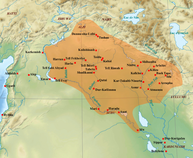
English: Map of the medio-assyrian kingdom (End of the 13th- beginning of the 11th centuries BC). Français : Carte des limites approximatives du royaume médio-assyrien à son apogée (Fin XIIIe-début XIe siècles av. J.-C.). Sources utilisées : Bertrand Lafont, Aline Tenu, Philippe Clancier et Francis Joannès, Mésopotamie : De Gilgamesh à Artaban (3300-120 av. J.-C.), Paris, Belin, coll. « Mondes anciens », 2017, p. 531 ; John Nicholas Postgate, Bronze Age Bureaucracy: Writing and the Practice of Government in Assyria, Cambridge, Cambridge University Press, 2013, p. 31 ; Martin Sauvage (dir.), Atlas historique du Proche-Orient ancien, Paris, Les Belles Lettres, 2020, p. 102. |
| Date | (UTC) |
| Source | |
| Author |
|
| Other versions | File:Medio assyrien.svg |
| This is a
retouched picture, which means that it has been digitally altered from its original version. Modifications: Ajout des limites du royaume médio-assyrien et des villes et sites archéologiques principaux.. The original can be viewed here:
Near East topographic map-blank.svg:
|
I, the copyright holder of this work, hereby publish it under the following licenses:
This file is licensed under the
Creative Commons Attribution-Share Alike
3.0 Unported,
2.5 Generic,
2.0 Generic and
1.0 Generic license.
- You are free:
- to share – to copy, distribute and transmit the work
- to remix – to adapt the work
- Under the following conditions:
- attribution – You must give appropriate credit, provide a link to the license, and indicate if changes were made. You may do so in any reasonable manner, but not in any way that suggests the licensor endorses you or your use.
- share alike – If you remix, transform, or build upon the material, you must distribute your contributions under the same or compatible license as the original.

|
Permission is granted to copy, distribute and/or modify this document under the terms of the GNU Free Documentation License, Version 1.2 or any later version published by the Free Software Foundation; with no Invariant Sections, no Front-Cover Texts, and no Back-Cover Texts. A copy of the license is included in the section entitled GNU Free Documentation License. |
You may select the license of your choice.
Original upload log
This image is a derivative work of the following images:
-
File:Near_East_topographic_map-blank.svg licensed with Cc-by-sa-3.0,2.5,2.0,1.0, GFDL
- 2009-08-18T18:31:37Z Sémhur 2425x1581 (2442670 Bytes) 3 - New try
- 2009-08-17T15:39:22Z Sémhur 2425x1581 (1815374 Bytes) 2 - With the background...
- 2009-08-17T15:37:36Z Sémhur 2425x1581 (2836 Bytes) {{Information |Description={{en|1=Blank physical map of the [[:en:Near East|Near East]]}} {{fr|1=Carte physique vierge du [[:fr:Proche-Orient|Proche-Orient]].}} |Source={{own}} |Author=[[User:Sémhur|Sémhur]] |Date=2008-08-1
Uploaded with derivativeFX
File history
Click on a date/time to view the file as it appeared at that time.
| Date/Time | Thumbnail | Dimensions | User | Comment | |
|---|---|---|---|---|---|
| current | 10:21, 7 March 2022 |
| 883 × 724 (724 KB) | Zunkir | ajouts et modifs |
| 20:59, 1 February 2018 |
 | 883 × 724 (714 KB) | Zunkir | Nouveaux sites, tracé, localisations. | |
| 13:16, 23 September 2010 |
 | 1,179 × 951 (1.6 MB) | Zunkir | Mise en couleur du royaume médio-assyrien, renommage de certains sites suivant leur nom antique. | |
| 12:48, 21 September 2010 |
 | 1,263 × 888 (1.73 MB) | Zunkir | {{Information |Description={{en|1=Map of the medio-assyrian kingdom (13th-12th centuries BC).}} {{fr|1=Carte des limites approximatives du royaume médio-assyrien à son apogée (XIIIe-XIIe siècles av. J.-C.).}} |Source=*[[:File:Near_East_topographic_map |
File usage
The following pages on the English Wikipedia use this file (pages on other projects are not listed):
Global file usage
The following other wikis use this file:
- Usage on ar.wikipedia.org
- Usage on bn.wikipedia.org
- Usage on ca.wikipedia.org
- Usage on cs.wikipedia.org
- Usage on de.wikipedia.org
- Usage on es.wikipedia.org
- Usage on fa.wikipedia.org
- Usage on fr.wikipedia.org
- Usage on hr.wikipedia.org
- Usage on hu.wikipedia.org
- Usage on hy.wikipedia.org
- Usage on id.wikipedia.org
- Usage on it.wikipedia.org
- Usage on ja.wikipedia.org
- Usage on ko.wikipedia.org
- Usage on lt.wikipedia.org
- Usage on nl.wikipedia.org
- Usage on pl.wikipedia.org
- Usage on pt.wikipedia.org
- Usage on ro.wikipedia.org
- Usage on ru.wikipedia.org
- Usage on sl.wikipedia.org
- Usage on ta.wikipedia.org
View more global usage of this file.
Size of this preview:
731 × 599 pixels. Other resolutions:
293 × 240 pixels |
586 × 480 pixels |
883 × 724 pixels.
Original file (883 × 724 pixels, file size: 724 KB, MIME type: image/png)
| This is a file from the
Wikimedia Commons. Information from its
description page there is shown below. Commons is a freely licensed media file repository. You can help. |
| Description |
English: Map of the medio-assyrian kingdom (End of the 13th- beginning of the 11th centuries BC). Français : Carte des limites approximatives du royaume médio-assyrien à son apogée (Fin XIIIe-début XIe siècles av. J.-C.). Sources utilisées : Bertrand Lafont, Aline Tenu, Philippe Clancier et Francis Joannès, Mésopotamie : De Gilgamesh à Artaban (3300-120 av. J.-C.), Paris, Belin, coll. « Mondes anciens », 2017, p. 531 ; John Nicholas Postgate, Bronze Age Bureaucracy: Writing and the Practice of Government in Assyria, Cambridge, Cambridge University Press, 2013, p. 31 ; Martin Sauvage (dir.), Atlas historique du Proche-Orient ancien, Paris, Les Belles Lettres, 2020, p. 102. |
| Date | (UTC) |
| Source | |
| Author |
|
| Other versions | File:Medio assyrien.svg |
| This is a
retouched picture, which means that it has been digitally altered from its original version. Modifications: Ajout des limites du royaume médio-assyrien et des villes et sites archéologiques principaux.. The original can be viewed here:
Near East topographic map-blank.svg:
|
I, the copyright holder of this work, hereby publish it under the following licenses:
This file is licensed under the
Creative Commons Attribution-Share Alike
3.0 Unported,
2.5 Generic,
2.0 Generic and
1.0 Generic license.
- You are free:
- to share – to copy, distribute and transmit the work
- to remix – to adapt the work
- Under the following conditions:
- attribution – You must give appropriate credit, provide a link to the license, and indicate if changes were made. You may do so in any reasonable manner, but not in any way that suggests the licensor endorses you or your use.
- share alike – If you remix, transform, or build upon the material, you must distribute your contributions under the same or compatible license as the original.
|
|
Permission is granted to copy, distribute and/or modify this document under the terms of the GNU Free Documentation License, Version 1.2 or any later version published by the Free Software Foundation; with no Invariant Sections, no Front-Cover Texts, and no Back-Cover Texts. A copy of the license is included in the section entitled GNU Free Documentation License. |
You may select the license of your choice.
Original upload log
This image is a derivative work of the following images:
-
File:Near_East_topographic_map-blank.svg licensed with Cc-by-sa-3.0,2.5,2.0,1.0, GFDL
- 2009-08-18T18:31:37Z Sémhur 2425x1581 (2442670 Bytes) 3 - New try
- 2009-08-17T15:39:22Z Sémhur 2425x1581 (1815374 Bytes) 2 - With the background...
- 2009-08-17T15:37:36Z Sémhur 2425x1581 (2836 Bytes) {{Information |Description={{en|1=Blank physical map of the [[:en:Near East|Near East]]}} {{fr|1=Carte physique vierge du [[:fr:Proche-Orient|Proche-Orient]].}} |Source={{own}} |Author=[[User:Sémhur|Sémhur]] |Date=2008-08-1
Uploaded with derivativeFX
File history
Click on a date/time to view the file as it appeared at that time.
| Date/Time | Thumbnail | Dimensions | User | Comment | |
|---|---|---|---|---|---|
| current | 10:21, 7 March 2022 |
| 883 × 724 (724 KB) | Zunkir | ajouts et modifs |
| 20:59, 1 February 2018 |
| 883 × 724 (714 KB) | Zunkir | Nouveaux sites, tracé, localisations. | |
| 13:16, 23 September 2010 |
| 1,179 × 951 (1.6 MB) | Zunkir | Mise en couleur du royaume médio-assyrien, renommage de certains sites suivant leur nom antique. | |
| 12:48, 21 September 2010 |
| 1,263 × 888 (1.73 MB) | Zunkir | {{Information |Description={{en|1=Map of the medio-assyrian kingdom (13th-12th centuries BC).}} {{fr|1=Carte des limites approximatives du royaume médio-assyrien à son apogée (XIIIe-XIIe siècles av. J.-C.).}} |Source=*[[:File:Near_East_topographic_map |
File usage
The following pages on the English Wikipedia use this file (pages on other projects are not listed):
Global file usage
The following other wikis use this file:
- Usage on ar.wikipedia.org
- Usage on bn.wikipedia.org
- Usage on ca.wikipedia.org
- Usage on cs.wikipedia.org
- Usage on de.wikipedia.org
- Usage on es.wikipedia.org
- Usage on fa.wikipedia.org
- Usage on fr.wikipedia.org
- Usage on hr.wikipedia.org
- Usage on hu.wikipedia.org
- Usage on hy.wikipedia.org
- Usage on id.wikipedia.org
- Usage on it.wikipedia.org
- Usage on ja.wikipedia.org
- Usage on ko.wikipedia.org
- Usage on lt.wikipedia.org
- Usage on nl.wikipedia.org
- Usage on pl.wikipedia.org
- Usage on pt.wikipedia.org
- Usage on ro.wikipedia.org
- Usage on ru.wikipedia.org
- Usage on sl.wikipedia.org
- Usage on ta.wikipedia.org
View more global usage of this file.