Size of this preview:
433 × 599 pixels. Other resolutions:
173 × 240 pixels |
347 × 480 pixels |
829 × 1,147 pixels.
Original file (829 × 1,147 pixels, file size: 481 KB, MIME type: image/jpeg)
| This is a file from the
Wikimedia Commons. Information from its
description page there is shown below. Commons is a freely licensed media file repository. You can help. |
| Description |
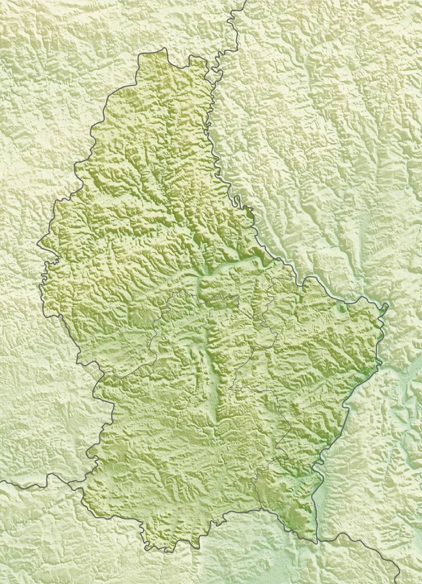
Deutsch: Physische Positionskarte von
Luxemburg
Quadratische Plattkarte. Geographische Begrenzung der Karte:
English: Physical location map of
Luxembourg
Equirectangular projection. Geographic limits of the map:
|
| Date | |
| Source | Own work, using map data from administrative map by Lencer and SRMT3-data for the relief |
| Author | Carport |
| Permission ( Reusing this file) |
This file is licensed under the
Creative Commons
Attribution-Share Alike 3.0 Unported license.
|
| Other versions |
|

File history
Click on a date/time to view the file as it appeared at that time.
| Date/Time | Thumbnail | Dimensions | User | Comment | |
|---|---|---|---|---|---|
| current | 14:39, 10 March 2010 |
| 829 × 1,147 (481 KB) | Carport | {{Information |Description={{de|Physische Positionskarte von {{w|Luxemburg|3=de}}}} Quadratische Plattkarte. Geographische Begrenzung der Karte: * N: 50.25° N * S: 49.4° N * W: 5.65° O * O: 6.6° O {{en|Physical location map of {{w|Luxembourg}}}} Equir |
File usage
The following pages on the English Wikipedia use this file (pages on other projects are not listed):
- Altmünster Abbey
- Esch-sur-Sûre Dam
- German-Luxembourg Nature Park
- Kneiff
- Le Juste Milieu Mosque
- Luxembourg City
- Luxembourg Open (golf)
- Luxembourg Sandstone
- Luxembourg Synagogue
- Menhir of Beisenerbierg
- Napoléonsgaard
- Our Natural Park
- Upper Sûre Lake
- Upper Sûre Natural Park
- User:DutchTreat/Projects/Places
- Module:Location map/data/Luxembourg
- Module:Location map/data/Luxembourg/doc
Global file usage
The following other wikis use this file:
- Usage on ar.wikipedia.org
- Usage on ast.wikipedia.org
- Usage on az.wikipedia.org
- Usage on ba.wikipedia.org
- Usage on bn.wikipedia.org
- Usage on bs.wikipedia.org
- Usage on ca.wikipedia.org
- Usage on ceb.wikipedia.org
- Usage on ce.wikipedia.org
- Usage on ckb.wikipedia.org
- Usage on cs.wikipedia.org
- Usage on cv.wikipedia.org
- Usage on de.wikipedia.org
- Usage on de.wikivoyage.org
View more global usage of this file.
Metadata
Size of this preview:
433 × 599 pixels. Other resolutions:
173 × 240 pixels |
347 × 480 pixels |
829 × 1,147 pixels.
Original file (829 × 1,147 pixels, file size: 481 KB, MIME type: image/jpeg)
| This is a file from the
Wikimedia Commons. Information from its
description page there is shown below. Commons is a freely licensed media file repository. You can help. |
| Description |
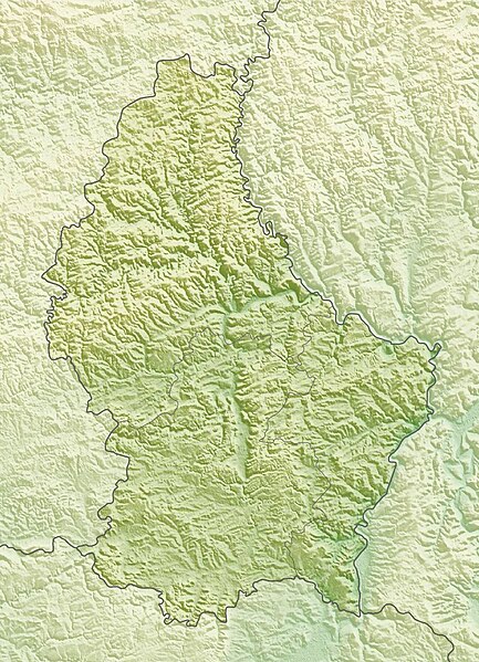
Deutsch: Physische Positionskarte von
Luxemburg
Quadratische Plattkarte. Geographische Begrenzung der Karte:
English: Physical location map of
Luxembourg
Equirectangular projection. Geographic limits of the map:
|
| Date | |
| Source | Own work, using map data from administrative map by Lencer and SRMT3-data for the relief |
| Author | Carport |
| Permission ( Reusing this file) |
This file is licensed under the
Creative Commons
Attribution-Share Alike 3.0 Unported license.
|
| Other versions |
|
File history
Click on a date/time to view the file as it appeared at that time.
| Date/Time | Thumbnail | Dimensions | User | Comment | |
|---|---|---|---|---|---|
| current | 14:39, 10 March 2010 |
| 829 × 1,147 (481 KB) | Carport | {{Information |Description={{de|Physische Positionskarte von {{w|Luxemburg|3=de}}}} Quadratische Plattkarte. Geographische Begrenzung der Karte: * N: 50.25° N * S: 49.4° N * W: 5.65° O * O: 6.6° O {{en|Physical location map of {{w|Luxembourg}}}} Equir |
File usage
The following pages on the English Wikipedia use this file (pages on other projects are not listed):
- Altmünster Abbey
- Esch-sur-Sûre Dam
- German-Luxembourg Nature Park
- Kneiff
- Le Juste Milieu Mosque
- Luxembourg City
- Luxembourg Open (golf)
- Luxembourg Sandstone
- Luxembourg Synagogue
- Menhir of Beisenerbierg
- Napoléonsgaard
- Our Natural Park
- Upper Sûre Lake
- Upper Sûre Natural Park
- User:DutchTreat/Projects/Places
- Module:Location map/data/Luxembourg
- Module:Location map/data/Luxembourg/doc
Global file usage
The following other wikis use this file:
- Usage on ar.wikipedia.org
- Usage on ast.wikipedia.org
- Usage on az.wikipedia.org
- Usage on ba.wikipedia.org
- Usage on bn.wikipedia.org
- Usage on bs.wikipedia.org
- Usage on ca.wikipedia.org
- Usage on ceb.wikipedia.org
- Usage on ce.wikipedia.org
- Usage on ckb.wikipedia.org
- Usage on cs.wikipedia.org
- Usage on cv.wikipedia.org
- Usage on de.wikipedia.org
- Usage on de.wikivoyage.org
View more global usage of this file.