
Original file (1,280 × 853 pixels, file size: 1.03 MB, MIME type: image/jpeg)
| This is a file from the
Wikimedia Commons. Information from its
description page there is shown below. Commons is a freely licensed media file repository. You can help. |
Summary
| Description |
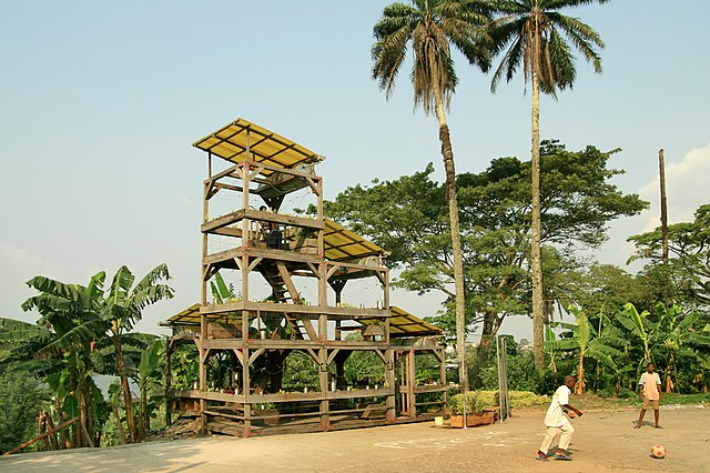
English: SUD Salon Urbain de Douala 2010. Triennial festival promoted by doual'art. Photo by Sandrine Dole. |
| Date | |
| Source | doual'art |
| Author | Sandrine Dole |
|
Lucas Grandin:
Le Jardin sonore
|
||||||||||||||||||||||||
|---|---|---|---|---|---|---|---|---|---|---|---|---|---|---|---|---|---|---|---|---|---|---|---|---|
| Artist |
|
 | ||||||||||||||||||||||
| Title |
Le jardin sonore (The sound garden) |
|||||||||||||||||||||||
| Object type |
installation artwork
|
|||||||||||||||||||||||
| Genre |
public art
|
|||||||||||||||||||||||
| Description |
A four floors structure irrigated by a system which collects water from the rain and it distributes it drop by drop to irrigate a botanical garden. The drops fall into small metallic cans and they produce an harmonic sound. |
|||||||||||||||||||||||
| Date | 2010 | |||||||||||||||||||||||
| Medium | mixed; wood, irrigation system, plants | |||||||||||||||||||||||
| Collection | ||||||||||||||||||||||||
| Current location | ||||||||||||||||||||||||
| Object location |
|
|||||||||||||||||||||||
| Object history |
The installation was built between February 2-22, 2010 and commissioned and produced by
|
|||||||||||||||||||||||
| Exhibition history |
It was presented during the
|
|||||||||||||||||||||||
| Notes | Public artwork, architectural installation and botanical garden. | |||||||||||||||||||||||
| References | Lucas Grandin, Le jardin sonore, Douala, 2010 on doual'art website. | |||||||||||||||||||||||
| Source/Photographer | doual'art | |||||||||||||||||||||||
| Permission ( Reusing this file) |
This file is licensed under the
Creative Commons
Attribution-Share Alike 3.0 Unported license.
| |||||||||||||||||||||||
| Attribution ( required by the license) | Lucas Grandin, Le jardin sonore de Bonamouti, Douala, 2010. Produced for the SUD Salon Urbain de Douala 2010 / Photo by [please refer to Author above] / Courtesy doual'art / Wikimedia Commons / | |||||||||||||||||||||||
| Other versions |
|
|||||||||||||||||||||||


English: This file was provided to Wikimedia Commons by
doual'art and it supports
WikiAfrica.
Français: Ce fichier a été mis sur Wikimedia Commons par
doual'art dans le cadre du projet
WikiAfrica.
Italiano: Questo documento è rilasciato a Wikimedia Commons da
doual'art e contribuisce al progetto
WikiAfrica.
- Permission OTRS ticket:2011101310013458 (message #6) covers all images provided by doual'art. Some photographers might have also provided individual permission.
Licensing
- You are free:
- to share – to copy, distribute and transmit the work
- to remix – to adapt the work
- Under the following conditions:
- attribution – You must give appropriate credit, provide a link to the license, and indicate if changes were made. You may do so in any reasonable manner, but not in any way that suggests the licensor endorses you or your use.
- share alike – If you remix, transform, or build upon the material, you must distribute your contributions under the same or compatible license as the original.
| Camera location |
| View this and other nearby images on: OpenStreetMap |
|
|---|
File history
Click on a date/time to view the file as it appeared at that time.
| Date/Time | Thumbnail | Dimensions | User | Comment | |
|---|---|---|---|---|---|
| current | 11:19, 12 February 2013 |
| 1,280 × 853 (1.03 MB) | Iopensa | User created page with UploadWizard |
File usage
Global file usage
The following other wikis use this file:
- Usage on de.wikipedia.org
- Usage on fr.wikipedia.org
- Usage on ig.wikipedia.org
- Usage on www.wikidata.org
Metadata
Original file (1,280 × 853 pixels, file size: 1.03 MB, MIME type: image/jpeg)
| This is a file from the
Wikimedia Commons. Information from its
description page there is shown below. Commons is a freely licensed media file repository. You can help. |
Summary
| Description |
English: SUD Salon Urbain de Douala 2010. Triennial festival promoted by doual'art. Photo by Sandrine Dole. |
| Date | |
| Source | doual'art |
| Author | Sandrine Dole |
|
Lucas Grandin:
Le Jardin sonore
|
||||||||||||||||||||||||
|---|---|---|---|---|---|---|---|---|---|---|---|---|---|---|---|---|---|---|---|---|---|---|---|---|
| Artist |
|
| ||||||||||||||||||||||
| Title |
Le jardin sonore (The sound garden) |
|||||||||||||||||||||||
| Object type |
installation artwork
|
|||||||||||||||||||||||
| Genre |
public art
|
|||||||||||||||||||||||
| Description |
A four floors structure irrigated by a system which collects water from the rain and it distributes it drop by drop to irrigate a botanical garden. The drops fall into small metallic cans and they produce an harmonic sound. |
|||||||||||||||||||||||
| Date | 2010 | |||||||||||||||||||||||
| Medium | mixed; wood, irrigation system, plants | |||||||||||||||||||||||
| Collection | ||||||||||||||||||||||||
| Current location | ||||||||||||||||||||||||
| Object location |
|
|||||||||||||||||||||||
| Object history |
The installation was built between February 2-22, 2010 and commissioned and produced by
|
|||||||||||||||||||||||
| Exhibition history |
It was presented during the
|
|||||||||||||||||||||||
| Notes | Public artwork, architectural installation and botanical garden. | |||||||||||||||||||||||
| References | Lucas Grandin, Le jardin sonore, Douala, 2010 on doual'art website. | |||||||||||||||||||||||
| Source/Photographer | doual'art | |||||||||||||||||||||||
| Permission ( Reusing this file) |
This file is licensed under the
Creative Commons
Attribution-Share Alike 3.0 Unported license.
| |||||||||||||||||||||||
| Attribution ( required by the license) | Lucas Grandin, Le jardin sonore de Bonamouti, Douala, 2010. Produced for the SUD Salon Urbain de Douala 2010 / Photo by [please refer to Author above] / Courtesy doual'art / Wikimedia Commons / | |||||||||||||||||||||||
| Other versions |
|
|||||||||||||||||||||||
English: This file was provided to Wikimedia Commons by
doual'art and it supports
WikiAfrica.
Français: Ce fichier a été mis sur Wikimedia Commons par
doual'art dans le cadre du projet
WikiAfrica.
Italiano: Questo documento è rilasciato a Wikimedia Commons da
doual'art e contribuisce al progetto
WikiAfrica.
- Permission OTRS ticket:2011101310013458 (message #6) covers all images provided by doual'art. Some photographers might have also provided individual permission.
Licensing
- You are free:
- to share – to copy, distribute and transmit the work
- to remix – to adapt the work
- Under the following conditions:
- attribution – You must give appropriate credit, provide a link to the license, and indicate if changes were made. You may do so in any reasonable manner, but not in any way that suggests the licensor endorses you or your use.
- share alike – If you remix, transform, or build upon the material, you must distribute your contributions under the same or compatible license as the original.
| Camera location |
| View this and other nearby images on: OpenStreetMap |
|
|---|
File history
Click on a date/time to view the file as it appeared at that time.
| Date/Time | Thumbnail | Dimensions | User | Comment | |
|---|---|---|---|---|---|
| current | 11:19, 12 February 2013 |
| 1,280 × 853 (1.03 MB) | Iopensa | User created page with UploadWizard |
File usage
Global file usage
The following other wikis use this file:
- Usage on de.wikipedia.org
- Usage on fr.wikipedia.org
- Usage on ig.wikipedia.org
- Usage on www.wikidata.org