Photos • Location


Size of this preview:
800 × 600 pixels. Other resolutions:
320 × 240 pixels |
640 × 480 pixels |
1,024 × 768 pixels |
1,280 × 960 pixels |
2,560 × 1,920 pixels |
4,000 × 3,000 pixels.
Original file (4,000 × 3,000 pixels, file size: 4.3 MB, MIME type: image/jpeg)
| This is a file from the
Wikimedia Commons. Information from its
description page there is shown below. Commons is a freely licensed media file repository. You can help. |
|
This is an image of a place or building that is listed on the
National Register of Historic Places in the
United States of America. Its reference number is
82003811. |
Summary
| Description |
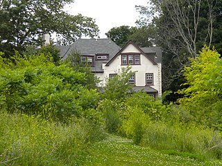
English: Lot at 401 W. Johnson Street near Lincoln Dr. and Cliveden Street. This shows the location of the Mayfair House on the NRHP since April 7, 1982, which has now been torn down (according to one reference anyway). 401 West Johnson Street in Germantown neighborhood of Northwest Philadelphia. The lot is in the foreground, in the background is the back of Connie Mack's house (believe it or not) on Cliveden Street |
| Date | |
| Source | Own work |
| Author | Smallbones |
| Camera location |
| View this and other nearby images on: OpenStreetMap |
|
|---|
Licensing
| I, the copyright holder of this work, release this work into the
public domain. This applies worldwide. In some countries this may not be legally possible; if so: I grant anyone the right to use this work for any purpose, without any conditions, unless such conditions are required by law. |
File history
Click on a date/time to view the file as it appeared at that time.
| Date/Time | Thumbnail | Dimensions | User | Comment | |
|---|---|---|---|---|---|
| current | 02:31, 8 June 2010 |
| 4,000 × 3,000 (4.3 MB) | Smallbones | {{Information |Description={{en|1=Lot at 401 W. Johnson Street near Lincoln Dr. and Cliveden Street. This shows the location of the Mayfair House on the NRHP since April 7, 1982, which has now been torn down (according to one reference anyway). 401 West |
File usage
The following pages on the English Wikipedia use this file (pages on other projects are not listed):
Global file usage
The following other wikis use this file:
- Usage on www.wikidata.org
Metadata
Size of this preview:
800 × 600 pixels. Other resolutions:
320 × 240 pixels |
640 × 480 pixels |
1,024 × 768 pixels |
1,280 × 960 pixels |
2,560 × 1,920 pixels |
4,000 × 3,000 pixels.
Original file (4,000 × 3,000 pixels, file size: 4.3 MB, MIME type: image/jpeg)
| This is a file from the
Wikimedia Commons. Information from its
description page there is shown below. Commons is a freely licensed media file repository. You can help. |
|
This is an image of a place or building that is listed on the
National Register of Historic Places in the
United States of America. Its reference number is
82003811. |
Summary
| Description |
English: Lot at 401 W. Johnson Street near Lincoln Dr. and Cliveden Street. This shows the location of the Mayfair House on the NRHP since April 7, 1982, which has now been torn down (according to one reference anyway). 401 West Johnson Street in Germantown neighborhood of Northwest Philadelphia. The lot is in the foreground, in the background is the back of Connie Mack's house (believe it or not) on Cliveden Street |
| Date | |
| Source | Own work |
| Author | Smallbones |
| Camera location |
| View this and other nearby images on: OpenStreetMap |
|
|---|
Licensing
| I, the copyright holder of this work, release this work into the
public domain. This applies worldwide. In some countries this may not be legally possible; if so: I grant anyone the right to use this work for any purpose, without any conditions, unless such conditions are required by law. |
File history
Click on a date/time to view the file as it appeared at that time.
| Date/Time | Thumbnail | Dimensions | User | Comment | |
|---|---|---|---|---|---|
| current | 02:31, 8 June 2010 |
| 4,000 × 3,000 (4.3 MB) | Smallbones | {{Information |Description={{en|1=Lot at 401 W. Johnson Street near Lincoln Dr. and Cliveden Street. This shows the location of the Mayfair House on the NRHP since April 7, 1982, which has now been torn down (according to one reference anyway). 401 West |
File usage
The following pages on the English Wikipedia use this file (pages on other projects are not listed):
Global file usage
The following other wikis use this file:
- Usage on www.wikidata.org