
Original file (1,000 × 800 pixels, file size: 1.82 MB, MIME type: image/png)
| This image has source information, but it either links directly to the image or is a generic base
URL, or is not an Internet source for an image that was likely found on the Internet. Source information should be provided so that the
copyright status can be verified by others. It is requested that a better source be provided to make determination of the copyright information easier. Please provide a URL to an
HTML page that contains this image. See
Wikipedia:Citing sources#Multimedia for more information.
Please remove this template once better source information is provided. Notify the uploader with: {{subst: bsr-user|1=File:Los Alamitos Curve 405,605,22.png}} ~~~~ |
Summary
| Description |
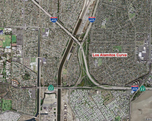
The Los Alamitos Curve interchange complex. | ||
|---|---|---|---|
| Source |
Underlying map is an aerial map obtained from the USGS The overlying work (freeway number shields, city labels, etc.) are by me. | ||
| Date | |||
| Author |
| ||
| Permission ( Reusing this file) |
See below.
|
Licensing
| This image is a work of a United States Geological Survey employee, taken or made as part of that person's official duties. As a work of the United States Government, the image is in the public domain in the US. For more information, see the USGS copyright policy. See Wikipedia:Public domain and Wikipedia:Copyrights for more details. |
|
| This media file is either in the public domain or published under a free license, and contains no inbound file links. If this media file is useful, then it should be transferred to the Wikimedia Commons. If this media is not useful, then please propose it for deletion or list it at files for discussion. |
File history
Click on a date/time to view the file as it appeared at that time.
| Date/Time | Thumbnail | Dimensions | User | Comment | |
|---|---|---|---|---|---|
| current | 03:23, 2 December 2007 |
| 1,000 × 800 (1.82 MB) | Mikeetc ( talk | contribs) | The Los Alamitos Curve interchange complex. Underlying map is an aerial map obtained from the USGS The overlying work (freeway number shields, city labels, etc.) are by me. |
You cannot overwrite this file.
File usage
Original file (1,000 × 800 pixels, file size: 1.82 MB, MIME type: image/png)
| This image has source information, but it either links directly to the image or is a generic base
URL, or is not an Internet source for an image that was likely found on the Internet. Source information should be provided so that the
copyright status can be verified by others. It is requested that a better source be provided to make determination of the copyright information easier. Please provide a URL to an
HTML page that contains this image. See
Wikipedia:Citing sources#Multimedia for more information.
Please remove this template once better source information is provided. Notify the uploader with: {{subst: bsr-user|1=File:Los Alamitos Curve 405,605,22.png}} ~~~~ |
Summary
| Description |
The Los Alamitos Curve interchange complex. | ||
|---|---|---|---|
| Source |
Underlying map is an aerial map obtained from the USGS The overlying work (freeway number shields, city labels, etc.) are by me. | ||
| Date | |||
| Author |
| ||
| Permission ( Reusing this file) |
See below.
|
Licensing
| This image is a work of a United States Geological Survey employee, taken or made as part of that person's official duties. As a work of the United States Government, the image is in the public domain in the US. For more information, see the USGS copyright policy. See Wikipedia:Public domain and Wikipedia:Copyrights for more details. |
|
| This media file is either in the public domain or published under a free license, and contains no inbound file links. If this media file is useful, then it should be transferred to the Wikimedia Commons. If this media is not useful, then please propose it for deletion or list it at files for discussion. |
File history
Click on a date/time to view the file as it appeared at that time.
| Date/Time | Thumbnail | Dimensions | User | Comment | |
|---|---|---|---|---|---|
| current | 03:23, 2 December 2007 |
| 1,000 × 800 (1.82 MB) | Mikeetc ( talk | contribs) | The Los Alamitos Curve interchange complex. Underlying map is an aerial map obtained from the USGS The overlying work (freeway number shields, city labels, etc.) are by me. |
You cannot overwrite this file.