
Original file (1,669 × 1,144 pixels, file size: 151 KB, MIME type: image/png)
| This is a file from the
Wikimedia Commons. Information from its
description page there is shown below. Commons is a freely licensed media file repository. You can help. |
Summary
| Description |
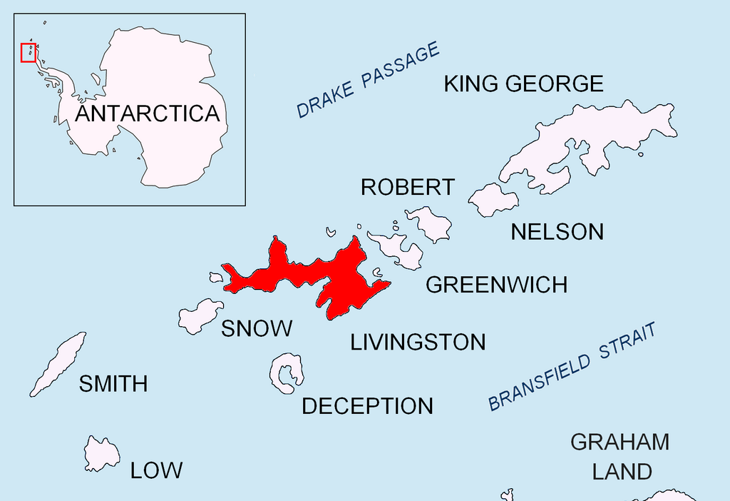
English: Location map of Livingston Island in the South Shetland Islands. |
| Date | |
| Source | Own work |
| Author | Apcbg |
Licensing
- You are free:
- to share – to copy, distribute and transmit the work
- to remix – to adapt the work
- Under the following conditions:
- attribution – You must give appropriate credit, provide a link to the license, and indicate if changes were made. You may do so in any reasonable manner, but not in any way that suggests the licensor endorses you or your use.
- share alike – If you remix, transform, or build upon the material, you must distribute your contributions under the same or compatible license as the original.
File history
Click on a date/time to view the file as it appeared at that time.
| Date/Time | Thumbnail | Dimensions | User | Comment | |
|---|---|---|---|---|---|
| current | 17:23, 24 August 2010 |
| 1,669 × 1,144 (151 KB) | Apcbg | + location in Antarctica |
| 18:52, 27 April 2010 |
 | 1,669 × 1,144 (5.47 MB) | Apcbg | {{Information |Description={{en|1=Location map of Livingston Island in the South Shetland Islands.}} |Source={{own}} |Author= Apcbg |Date=2010-04-27 |Permission= |other_versions= }} Category:Maps of Antarctica |
File usage
More than 100 pages use this file. The following list shows the first 100 pages that use this file only. A full list is available.
- Aheloy Nunatak
- Aleko Point
- Amadok Point
- Avitohol Point
- Aytos Point
- Balkan Snowfield
- Barclay Bay
- Belchin Rock
- Berkovitsa Glacier
- Beroe Hill
- Bilyar Point
- Binn Peak
- Bruix Cove
- Brunow Bay
- Burdick Peak
- Burdick Ridge
- Burdick South Peak
- Burdick West Peak
- Castra Martis Hill
- Chapman Rocks
- Christoff Cliff
- Clark Nunatak
- Craggy Island (Livingston Island)
- Dimov Gate
- Dunbar Islands
- Elephant Point
- Elhovo Gap
- Eliza Rocks
- Emona Anchorage
- Enchantress Rocks
- Ereby Point
- Erma Knoll
- Etar Snowfield
- Etropole Peak
- False Bay (Livingston Island)
- Gleaner Heights
- Gurev Gap
- Hannah Point
- Hemus Peak
- Hero Bay
- Huntress Glacier
- Indian Rocks
- Iskar Glacier
- John Beach (Livingston Island)
- Kaliakra Glacier
- Kamchiya Glacier
- Kavarna Cove
- Koynare Rocks
- Krakra Bluff
- Kresna Gully
- Kuklen Point
- Kuzman Knoll
- Leslie Hill (Livingston Island)
- Lukovit Point
- Lynx Rocks
- M'Kean Point
- Maleshevo Cove
- Melnik Peak
- Melnik Ridge
- Melta Point
- Nedelya Point
- Orpheus Gate
- Perunika Glacier
- Pimpirev Beach
- Pimpirev Glacier
- Pliska Ridge
- Prisoe Cove
- Raquelia Rocks
- Rezen Knoll
- Rezen Saddle
- Ritli Hill
- Rongel Point
- Rongel Reef
- Rotch Dome
- Rowe Point
- Saedinenie Snowfield
- Samokov Knoll
- San Telmo Island
- Siddins Point
- Skravena Cove
- Slab Point
- Sliven Peak
- Smolyan Point
- Snow Peak (Antarctica)
- South Bay (Livingston Island)
- Struma Glacier
- Telish Rock
- Teres Ridge
- Tundzha Glacier
- Ustra Peak
- Valchedram Island
- Vasilev Bay
- Vazov Point
- Verila Glacier
- Walker Bay (Livingston Island)
- Willan Nunatak
- Willan Saddle
- Wörner Gap
- Yana Point
- Yankov Gap
View more links to this file.
Global file usage
The following other wikis use this file:
- Usage on ar.wikipedia.org
- Usage on az.wikipedia.org
- Usage on bg.wikipedia.org
- Берое (хълм)
- Монтана (връх)
- Берковица (ледник)
- Златоградски камък
- Амадок (нос)
- Алеко (нос)
- Емона (залив в Антарктика)
- Пимпирев бряг
- Перуника (ледник)
- Смолян (нос)
- Пимпирев ледник
- Айтос (нос)
- Авитохол (нос)
- Биляр (нос)
- Елемаг (нос)
- Куклен (нос)
- Луковит (нос)
- Мелта (нос)
- Баба Неделя (нос)
- Ронжел (нос)
- Синдел (нос)
- Вазов (нос)
- Яна (нос)
- Хан Аспарух (връх)
- Атанасов нунатак
- Южен Бърдик
- Чирпан (връх)
- Хемус (връх)
- Скравена (залив)
- Usage on ceb.wikipedia.org
- Usage on es.wikipedia.org
- Usage on fr.wikipedia.org
- Usage on ko.wikipedia.org
- Usage on lv.wikipedia.org
- Usage on nn.wikipedia.org
View more global usage of this file.
Original file (1,669 × 1,144 pixels, file size: 151 KB, MIME type: image/png)
| This is a file from the
Wikimedia Commons. Information from its
description page there is shown below. Commons is a freely licensed media file repository. You can help. |
Summary
| Description |
English: Location map of Livingston Island in the South Shetland Islands. |
| Date | |
| Source | Own work |
| Author | Apcbg |
Licensing
- You are free:
- to share – to copy, distribute and transmit the work
- to remix – to adapt the work
- Under the following conditions:
- attribution – You must give appropriate credit, provide a link to the license, and indicate if changes were made. You may do so in any reasonable manner, but not in any way that suggests the licensor endorses you or your use.
- share alike – If you remix, transform, or build upon the material, you must distribute your contributions under the same or compatible license as the original.
File history
Click on a date/time to view the file as it appeared at that time.
| Date/Time | Thumbnail | Dimensions | User | Comment | |
|---|---|---|---|---|---|
| current | 17:23, 24 August 2010 |
| 1,669 × 1,144 (151 KB) | Apcbg | + location in Antarctica |
| 18:52, 27 April 2010 |
| 1,669 × 1,144 (5.47 MB) | Apcbg | {{Information |Description={{en|1=Location map of Livingston Island in the South Shetland Islands.}} |Source={{own}} |Author= Apcbg |Date=2010-04-27 |Permission= |other_versions= }} Category:Maps of Antarctica |
File usage
More than 100 pages use this file. The following list shows the first 100 pages that use this file only. A full list is available.
- Aheloy Nunatak
- Aleko Point
- Amadok Point
- Avitohol Point
- Aytos Point
- Balkan Snowfield
- Barclay Bay
- Belchin Rock
- Berkovitsa Glacier
- Beroe Hill
- Bilyar Point
- Binn Peak
- Bruix Cove
- Brunow Bay
- Burdick Peak
- Burdick Ridge
- Burdick South Peak
- Burdick West Peak
- Castra Martis Hill
- Chapman Rocks
- Christoff Cliff
- Clark Nunatak
- Craggy Island (Livingston Island)
- Dimov Gate
- Dunbar Islands
- Elephant Point
- Elhovo Gap
- Eliza Rocks
- Emona Anchorage
- Enchantress Rocks
- Ereby Point
- Erma Knoll
- Etar Snowfield
- Etropole Peak
- False Bay (Livingston Island)
- Gleaner Heights
- Gurev Gap
- Hannah Point
- Hemus Peak
- Hero Bay
- Huntress Glacier
- Indian Rocks
- Iskar Glacier
- John Beach (Livingston Island)
- Kaliakra Glacier
- Kamchiya Glacier
- Kavarna Cove
- Koynare Rocks
- Krakra Bluff
- Kresna Gully
- Kuklen Point
- Kuzman Knoll
- Leslie Hill (Livingston Island)
- Lukovit Point
- Lynx Rocks
- M'Kean Point
- Maleshevo Cove
- Melnik Peak
- Melnik Ridge
- Melta Point
- Nedelya Point
- Orpheus Gate
- Perunika Glacier
- Pimpirev Beach
- Pimpirev Glacier
- Pliska Ridge
- Prisoe Cove
- Raquelia Rocks
- Rezen Knoll
- Rezen Saddle
- Ritli Hill
- Rongel Point
- Rongel Reef
- Rotch Dome
- Rowe Point
- Saedinenie Snowfield
- Samokov Knoll
- San Telmo Island
- Siddins Point
- Skravena Cove
- Slab Point
- Sliven Peak
- Smolyan Point
- Snow Peak (Antarctica)
- South Bay (Livingston Island)
- Struma Glacier
- Telish Rock
- Teres Ridge
- Tundzha Glacier
- Ustra Peak
- Valchedram Island
- Vasilev Bay
- Vazov Point
- Verila Glacier
- Walker Bay (Livingston Island)
- Willan Nunatak
- Willan Saddle
- Wörner Gap
- Yana Point
- Yankov Gap
View more links to this file.
Global file usage
The following other wikis use this file:
- Usage on ar.wikipedia.org
- Usage on az.wikipedia.org
- Usage on bg.wikipedia.org
- Берое (хълм)
- Монтана (връх)
- Берковица (ледник)
- Златоградски камък
- Амадок (нос)
- Алеко (нос)
- Емона (залив в Антарктика)
- Пимпирев бряг
- Перуника (ледник)
- Смолян (нос)
- Пимпирев ледник
- Айтос (нос)
- Авитохол (нос)
- Биляр (нос)
- Елемаг (нос)
- Куклен (нос)
- Луковит (нос)
- Мелта (нос)
- Баба Неделя (нос)
- Ронжел (нос)
- Синдел (нос)
- Вазов (нос)
- Яна (нос)
- Хан Аспарух (връх)
- Атанасов нунатак
- Южен Бърдик
- Чирпан (връх)
- Хемус (връх)
- Скравена (залив)
- Usage on ceb.wikipedia.org
- Usage on es.wikipedia.org
- Usage on fr.wikipedia.org
- Usage on ko.wikipedia.org
- Usage on lv.wikipedia.org
- Usage on nn.wikipedia.org
View more global usage of this file.