
Size of this PNG preview of this SVG file:
510 × 600 pixels. Other resolutions:
204 × 240 pixels |
408 × 480 pixels |
653 × 768 pixels |
871 × 1,024 pixels |
1,742 × 2,048 pixels |
3,360 × 3,950 pixels.
Original file (SVG file, nominally 3,360 × 3,950 pixels, file size: 924 KB)
| This is a file from the
Wikimedia Commons. Information from its
description page there is shown below. Commons is a freely licensed media file repository. You can help. |
Summary
| Description |
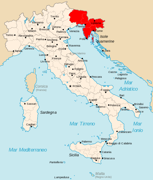
English: map of the Operationszone Adriatisches Küstenland in Kingdom of Italy (Regno d'Italia).
Italiano: cartina del
Litorale Adriatico del Regno d'Italia nel 1942. |
| Date | |
| Source | Own work, original from Derivative works of this file: Kingdom of Italy 1942 with provinces.svg |
| Author | Gigillo83 |
Licensing
I, the copyright holder of this work, hereby publish it under the following licenses:

|
Permission is granted to copy, distribute and/or modify this document under the terms of the GNU Free Documentation License, Version 1.2 or any later version published by the Free Software Foundation; with no Invariant Sections, no Front-Cover Texts, and no Back-Cover Texts. A copy of the license is included in the section entitled GNU Free Documentation License. |
This file is licensed under the
Creative Commons
Attribution 3.0 Unported license.
- You are free:
- to share – to copy, distribute and transmit the work
- to remix – to adapt the work
- Under the following conditions:
- attribution – You must give appropriate credit, provide a link to the license, and indicate if changes were made. You may do so in any reasonable manner, but not in any way that suggests the licensor endorses you or your use.
You may select the license of your choice.
File history
Click on a date/time to view the file as it appeared at that time.
| Date/Time | Thumbnail | Dimensions | User | Comment | |
|---|---|---|---|---|---|
| current | 14:24, 20 January 2013 |
| 3,360 × 3,950 (924 KB) | Tomobe03 | Removed island of Krk from the OZAK territory per book source: Germany and the Second World War, Volume 5, By Bernhard Kroener, Rolf-Dieter Müller, Hans Umbreit; url: http://books.google.hr/books?id=3JxIMY9SVWUC isbn: 9780198208730, map on page 85 |
| 16:33, 15 June 2011 |
 | 3,360 × 3,950 (924 KB) | Gigillo83 | == Summary == {{Information |Description={{en|map of the Operationszone Adriatisches Küstenland in Kingdom of Italy (Regno d'Italia).}} {{it|cartina del '' Litorale Adriatico'' del Regno d'Italia nel 1942.}} |S |
File usage
The following pages on the English Wikipedia use this file (pages on other projects are not listed):
Global file usage
The following other wikis use this file:
- Usage on bs.wikipedia.org
- Usage on de.wikipedia.org
- Usage on el.wikipedia.org
- Usage on es.wikipedia.org
- Usage on fr.wikipedia.org
- Usage on hr.wikipedia.org
- Usage on id.wikipedia.org
- Usage on it.wikipedia.org
- Usage on ko.wikipedia.org
- Usage on ms.wikipedia.org
- Usage on nl.wikipedia.org
- Usage on no.wikipedia.org
- Usage on pt.wikipedia.org
- Usage on ro.wikipedia.org
- Usage on sh.wikipedia.org
- Usage on sr.wikipedia.org
- Usage on sv.wikipedia.org
- Usage on uk.wikipedia.org
- Usage on zh.wikipedia.org
Metadata
Size of this PNG preview of this SVG file:
510 × 600 pixels. Other resolutions:
204 × 240 pixels |
408 × 480 pixels |
653 × 768 pixels |
871 × 1,024 pixels |
1,742 × 2,048 pixels |
3,360 × 3,950 pixels.
Original file (SVG file, nominally 3,360 × 3,950 pixels, file size: 924 KB)
| This is a file from the
Wikimedia Commons. Information from its
description page there is shown below. Commons is a freely licensed media file repository. You can help. |
Summary
| Description |
English: map of the Operationszone Adriatisches Küstenland in Kingdom of Italy (Regno d'Italia).
Italiano: cartina del
Litorale Adriatico del Regno d'Italia nel 1942. |
| Date | |
| Source | Own work, original from Derivative works of this file: Kingdom of Italy 1942 with provinces.svg |
| Author | Gigillo83 |
Licensing
I, the copyright holder of this work, hereby publish it under the following licenses:
|
|
Permission is granted to copy, distribute and/or modify this document under the terms of the GNU Free Documentation License, Version 1.2 or any later version published by the Free Software Foundation; with no Invariant Sections, no Front-Cover Texts, and no Back-Cover Texts. A copy of the license is included in the section entitled GNU Free Documentation License. |
This file is licensed under the
Creative Commons
Attribution 3.0 Unported license.
- You are free:
- to share – to copy, distribute and transmit the work
- to remix – to adapt the work
- Under the following conditions:
- attribution – You must give appropriate credit, provide a link to the license, and indicate if changes were made. You may do so in any reasonable manner, but not in any way that suggests the licensor endorses you or your use.
You may select the license of your choice.
File history
Click on a date/time to view the file as it appeared at that time.
| Date/Time | Thumbnail | Dimensions | User | Comment | |
|---|---|---|---|---|---|
| current | 14:24, 20 January 2013 |
| 3,360 × 3,950 (924 KB) | Tomobe03 | Removed island of Krk from the OZAK territory per book source: Germany and the Second World War, Volume 5, By Bernhard Kroener, Rolf-Dieter Müller, Hans Umbreit; url: http://books.google.hr/books?id=3JxIMY9SVWUC isbn: 9780198208730, map on page 85 |
| 16:33, 15 June 2011 |
| 3,360 × 3,950 (924 KB) | Gigillo83 | == Summary == {{Information |Description={{en|map of the Operationszone Adriatisches Küstenland in Kingdom of Italy (Regno d'Italia).}} {{it|cartina del '' Litorale Adriatico'' del Regno d'Italia nel 1942.}} |S |
File usage
The following pages on the English Wikipedia use this file (pages on other projects are not listed):
Global file usage
The following other wikis use this file:
- Usage on bs.wikipedia.org
- Usage on de.wikipedia.org
- Usage on el.wikipedia.org
- Usage on es.wikipedia.org
- Usage on fr.wikipedia.org
- Usage on hr.wikipedia.org
- Usage on id.wikipedia.org
- Usage on it.wikipedia.org
- Usage on ko.wikipedia.org
- Usage on ms.wikipedia.org
- Usage on nl.wikipedia.org
- Usage on no.wikipedia.org
- Usage on pt.wikipedia.org
- Usage on ro.wikipedia.org
- Usage on sh.wikipedia.org
- Usage on sr.wikipedia.org
- Usage on sv.wikipedia.org
- Usage on uk.wikipedia.org
- Usage on zh.wikipedia.org