
Size of this PNG preview of this SVG file:
800 × 521 pixels. Other resolutions:
320 × 208 pixels |
640 × 417 pixels |
1,024 × 667 pixels |
1,280 × 834 pixels |
2,560 × 1,667 pixels |
1,425 × 928 pixels.
Original file (SVG file, nominally 1,425 × 928 pixels, file size: 787 KB)
| This is a file from the
Wikimedia Commons. Information from its
description page there is shown below. Commons is a freely licensed media file repository. You can help. |
| Description |
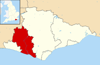
Map of East Sussex, UK with Lewes district highlighted. Equirectangular map projection on WGS 84 datum, with N/S stretched 155% |
| Date | |
| Source |
|
| Author | Nilfanion, created using Ordnance Survey data |
| Permission ( Reusing this file) |
This file is licensed under the
Creative Commons
Attribution-Share Alike 3.0 Unported license. Attribution: Contains Ordnance Survey data © Crown copyright and database right
|
File history
Click on a date/time to view the file as it appeared at that time.
| Date/Time | Thumbnail | Dimensions | User | Comment | |
|---|---|---|---|---|---|
| current | 11:35, 10 March 2011 |
| 1,425 × 928 (787 KB) | Nilfanion | {{Information |Description=Map of East Sussex, UK with Lewes district highlighted. Equirectangular map projection on WGS 84 datum, with N/S stretched 155% |Source= Ordnance Survey [https://www |
File usage
The following pages on the English Wikipedia use this file (pages on other projects are not listed):
Global file usage
The following other wikis use this file:
- Usage on ast.wikipedia.org
- Usage on cy.wikipedia.org
- Usage on es.wikipedia.org
- Usage on fr.wikipedia.org
- Lewes
- Newhaven (Sussex de l'Est)
- Firle
- Seaford
- Rodmell
- District de Lewes
- Kingston near Lewes
- Southease
- Falmer
- Ditchling
- Peacehaven
- Ringmer
- Bishopstone (Sussex de l'Est)
- Beddingham
- Modèle:Palette District de Lewes
- Chailey
- East Chiltington
- Glynde
- Hamsey
- Piddinghoe
- Westmeston
- Streat
- Tarring Neville
- Barcombe
- South Heighton
- Telscombe
- Wivelsfield
- Plumpton (Sussex de l'Est)
- Newick (Royaume-Uni)
- Iford
- Usage on ja.wikipedia.org
- Usage on ko.wikipedia.org
- Usage on lv.wikipedia.org
- Usage on nl.wikipedia.org
- Usage on no.wikipedia.org
- Usage on pl.wikipedia.org
- Usage on pl.wiktionary.org
- Usage on ru.wikipedia.org
- Usage on sh.wikipedia.org
- Usage on sv.wikipedia.org
- Usage on ur.wikipedia.org
- Usage on www.wikidata.org
- Usage on zh-min-nan.wikipedia.org
Size of this PNG preview of this SVG file:
800 × 521 pixels. Other resolutions:
320 × 208 pixels |
640 × 417 pixels |
1,024 × 667 pixels |
1,280 × 834 pixels |
2,560 × 1,667 pixels |
1,425 × 928 pixels.
Original file (SVG file, nominally 1,425 × 928 pixels, file size: 787 KB)
| This is a file from the
Wikimedia Commons. Information from its
description page there is shown below. Commons is a freely licensed media file repository. You can help. |
| Description |
Map of East Sussex, UK with Lewes district highlighted. Equirectangular map projection on WGS 84 datum, with N/S stretched 155% |
| Date | |
| Source |
|
| Author | Nilfanion, created using Ordnance Survey data |
| Permission ( Reusing this file) |
This file is licensed under the
Creative Commons
Attribution-Share Alike 3.0 Unported license. Attribution: Contains Ordnance Survey data © Crown copyright and database right
|
File history
Click on a date/time to view the file as it appeared at that time.
| Date/Time | Thumbnail | Dimensions | User | Comment | |
|---|---|---|---|---|---|
| current | 11:35, 10 March 2011 |
| 1,425 × 928 (787 KB) | Nilfanion | {{Information |Description=Map of East Sussex, UK with Lewes district highlighted. Equirectangular map projection on WGS 84 datum, with N/S stretched 155% |Source= Ordnance Survey [https://www |
File usage
The following pages on the English Wikipedia use this file (pages on other projects are not listed):
Global file usage
The following other wikis use this file:
- Usage on ast.wikipedia.org
- Usage on cy.wikipedia.org
- Usage on es.wikipedia.org
- Usage on fr.wikipedia.org
- Lewes
- Newhaven (Sussex de l'Est)
- Firle
- Seaford
- Rodmell
- District de Lewes
- Kingston near Lewes
- Southease
- Falmer
- Ditchling
- Peacehaven
- Ringmer
- Bishopstone (Sussex de l'Est)
- Beddingham
- Modèle:Palette District de Lewes
- Chailey
- East Chiltington
- Glynde
- Hamsey
- Piddinghoe
- Westmeston
- Streat
- Tarring Neville
- Barcombe
- South Heighton
- Telscombe
- Wivelsfield
- Plumpton (Sussex de l'Est)
- Newick (Royaume-Uni)
- Iford
- Usage on ja.wikipedia.org
- Usage on ko.wikipedia.org
- Usage on lv.wikipedia.org
- Usage on nl.wikipedia.org
- Usage on no.wikipedia.org
- Usage on pl.wikipedia.org
- Usage on pl.wiktionary.org
- Usage on ru.wikipedia.org
- Usage on sh.wikipedia.org
- Usage on sv.wikipedia.org
- Usage on ur.wikipedia.org
- Usage on www.wikidata.org
- Usage on zh-min-nan.wikipedia.org