
Size of this preview:
705 × 600 pixels. Other resolutions:
282 × 240 pixels |
564 × 480 pixels |
1,000 × 851 pixels.
Original file (1,000 × 851 pixels, file size: 132 KB, MIME type: image/jpeg)
| This is a file from the
Wikimedia Commons. Information from its
description page there is shown below. Commons is a freely licensed media file repository. You can help. |
Summary
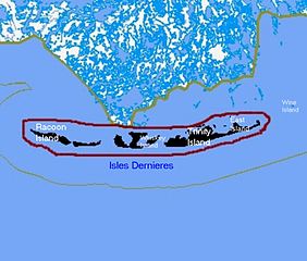
| Description | Map of remaining portions of Last Island, Louisiana |
| Date | |
| Source | Map drawn by en:User:sf46 based on information gathered from U.S. Federal Government website: census.gov |
| Author | en:User:sf46 |
| Permission ( Reusing this file) |
Released to public domain |
Licensing
This work is in the
public domain in the United States because it is a
work prepared by an officer or employee of the United States Government as part of that person’s official duties under the terms of
Title 17, Chapter 1, Section 105 of the
US Code.
Note: This only applies to original works of the Federal Government and not to the work of any individual
U.S. state,
territory, commonwealth, county, municipality, or any other subdivision. This template also does not apply to postage stamp designs published by the
United States Postal Service
since 1978. (See §
313.6(C)(1) of Compendium of U.S. Copyright Office Practices). It also does not apply to certain US coins; see
The US Mint Terms of Use.
|
 | |
| This file has been identified as being free of known restrictions under copyright law, including all related and neighboring rights. | ||
File history
Click on a date/time to view the file as it appeared at that time.
| Date/Time | Thumbnail | Dimensions | User | Comment | |
|---|---|---|---|---|---|
| current | 01:52, 27 August 2010 |
| 1,000 × 851 (132 KB) | Lynntoniolondon | {{Information |Description=Map of remaining portions of Last Island, Louisiana |Source=Map drawn by User:sf46 based on information gathered from U.S. Federal Government website: [http://www.census.gov census.gov] |Date=6/26/2009 |Author=[[User:sf4 |
File usage
The following pages on the English Wikipedia use this file (pages on other projects are not listed):
Global file usage
The following other wikis use this file:
- Usage on fr.wikipedia.org
- Usage on ja.wikipedia.org
- Usage on www.wikidata.org
Metadata
Size of this preview:
705 × 600 pixels. Other resolutions:
282 × 240 pixels |
564 × 480 pixels |
1,000 × 851 pixels.
Original file (1,000 × 851 pixels, file size: 132 KB, MIME type: image/jpeg)
| This is a file from the
Wikimedia Commons. Information from its
description page there is shown below. Commons is a freely licensed media file repository. You can help. |
Summary
| Description | Map of remaining portions of Last Island, Louisiana |
| Date | |
| Source | Map drawn by en:User:sf46 based on information gathered from U.S. Federal Government website: census.gov |
| Author | en:User:sf46 |
| Permission ( Reusing this file) |
Released to public domain |
Licensing
This work is in the
public domain in the United States because it is a
work prepared by an officer or employee of the United States Government as part of that person’s official duties under the terms of
Title 17, Chapter 1, Section 105 of the
US Code.
Note: This only applies to original works of the Federal Government and not to the work of any individual
U.S. state,
territory, commonwealth, county, municipality, or any other subdivision. This template also does not apply to postage stamp designs published by the
United States Postal Service
since 1978. (See §
313.6(C)(1) of Compendium of U.S. Copyright Office Practices). It also does not apply to certain US coins; see
The US Mint Terms of Use.
|
| |
| This file has been identified as being free of known restrictions under copyright law, including all related and neighboring rights. | ||
File history
Click on a date/time to view the file as it appeared at that time.
| Date/Time | Thumbnail | Dimensions | User | Comment | |
|---|---|---|---|---|---|
| current | 01:52, 27 August 2010 |
| 1,000 × 851 (132 KB) | Lynntoniolondon | {{Information |Description=Map of remaining portions of Last Island, Louisiana |Source=Map drawn by User:sf46 based on information gathered from U.S. Federal Government website: [http://www.census.gov census.gov] |Date=6/26/2009 |Author=[[User:sf4 |
File usage
The following pages on the English Wikipedia use this file (pages on other projects are not listed):
Global file usage
The following other wikis use this file:
- Usage on fr.wikipedia.org
- Usage on ja.wikipedia.org
- Usage on www.wikidata.org