PhotosLocation

This is a file from the Wikimedia Commons
From Wikipedia, the free encyclopedia

Original file(955 × 666 pixels, file size: 1.31 MB, MIME type: image/png)

Summary

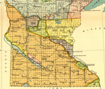
Description Details from 18th Annual Report, Plate 104—Minnesota, 1: Map of the w:Half-Breed Tract in Minnesota, a reservation designated for individuals of mixed American Indian and European descent. This reservation was designated in the 1830 w:Treaty of Prarie du Chien.
Date
Source Indian Land Cessions in the United States, 1784 to 1894: Minnesota map
Author Charles C. Royce, editor
Published by United States Bureau of American Ethnology, Washington, DC
Lithography by A. Moen & Co., Baltimore, MD
Other versions
Camera location 44° 23′ 00″ N, 92° 20′ 00″ W  Kartographer map based on OpenStreetMap.View this and other nearby images on: OpenStreetMap info

Licensing

Public domain This work is from the Library of Congress. According to the library, there are no known copyright restrictions on the use of this work.

Information (Geography)

Captions

Add a one-line explanation of what this file represents

Items portrayed in this file

depicts

44°22'59.999"N, 92°19'59.999"W

File history

Click on a date/time to view the file as it appeared at that time.

Date/TimeThumbnailDimensionsUserComment
current 14:33, 30 January 2008 Thumbnail for version as of 14:33, 30 January 2008955 × 666 (1.31 MB) Elkman{{Information |Description=Map of the w:Half-Breed Tract in Minnesota, a reservation designated for individuals of mixed American Indian and European descent. This reservation was designated in the 1830 w:Treaty of Prarie du Chien. |Sour
The following pages on the English Wikipedia use this file (pages on other projects are not listed):

Metadata

This is a file from the Wikimedia Commons
From Wikipedia, the free encyclopedia

Original file(955 × 666 pixels, file size: 1.31 MB, MIME type: image/png)

Summary

Description Details from 18th Annual Report, Plate 104—Minnesota, 1: Map of the w:Half-Breed Tract in Minnesota, a reservation designated for individuals of mixed American Indian and European descent. This reservation was designated in the 1830 w:Treaty of Prarie du Chien.
Date
Source Indian Land Cessions in the United States, 1784 to 1894: Minnesota map
Author Charles C. Royce, editor
Published by United States Bureau of American Ethnology, Washington, DC
Lithography by A. Moen & Co., Baltimore, MD
Other versions
Camera location 44° 23′ 00″ N, 92° 20′ 00″ W  Kartographer map based on OpenStreetMap.View this and other nearby images on: OpenStreetMap info

Licensing

Public domain This work is from the Library of Congress. According to the library, there are no known copyright restrictions on the use of this work.

Information (Geography)

Captions

Add a one-line explanation of what this file represents

Items portrayed in this file

depicts

44°22'59.999"N, 92°19'59.999"W

File history

Click on a date/time to view the file as it appeared at that time.

Date/TimeThumbnailDimensionsUserComment
current 14:33, 30 January 2008 Thumbnail for version as of 14:33, 30 January 2008955 × 666 (1.31 MB) Elkman{{Information |Description=Map of the w:Half-Breed Tract in Minnesota, a reservation designated for individuals of mixed American Indian and European descent. This reservation was designated in the 1830 w:Treaty of Prarie du Chien. |Sour
The following pages on the English Wikipedia use this file (pages on other projects are not listed):
Metadata


Videos

Youtube | Vimeo | Bing

Websites

Google | Yahoo | Bing

Encyclopedia

Google | Yahoo | Bing

Facebook