
Size of this PNG preview of this SVG file:
800 × 471 pixels. Other resolutions:
320 × 188 pixels |
640 × 377 pixels |
1,024 × 603 pixels |
1,280 × 753 pixels |
2,560 × 1,506 pixels |
1,205 × 709 pixels.
Original file (SVG file, nominally 1,205 × 709 pixels, file size: 347 KB)
| This is a file from the
Wikimedia Commons. Information from its
description page there is shown below. Commons is a freely licensed media file repository. You can help. |
Summary
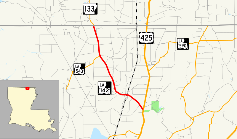
| Description | Map of Louisiana Highway 142 |
| Date | |
| Source | Own work, data from U.S. Census Bureau |
| Author | Mr. Matté (if there is an issue with this image, contact me using this image's Commons talk page, my Commons user talk page, or my English Wikipedia user talk page; I'll know about it a lot faster) |
| SVG development |
Licensing
I, the copyright holder of this work, hereby publish it under the following licenses:

|
Permission is granted to copy, distribute and/or modify this document under the terms of the GNU Free Documentation License, Version 1.2 or any later version published by the Free Software Foundation; with no Invariant Sections, no Front-Cover Texts, and no Back-Cover Texts. A copy of the license is included in the section entitled GNU Free Documentation License. |
This file is licensed under the
Creative Commons Attribution-Share Alike
3.0 Unported,
2.5 Generic,
2.0 Generic and
1.0 Generic license.
- You are free:
- to share – to copy, distribute and transmit the work
- to remix – to adapt the work
- Under the following conditions:
- attribution – You must give appropriate credit, provide a link to the license, and indicate if changes were made. You may do so in any reasonable manner, but not in any way that suggests the licensor endorses you or your use.
- share alike – If you remix, transform, or build upon the material, you must distribute your contributions under the same or compatible license as the original.
You may select the license of your choice.
File history
Click on a date/time to view the file as it appeared at that time.
| Date/Time | Thumbnail | Dimensions | User | Comment | |
|---|---|---|---|---|---|
| current | 01:19, 30 November 2014 |
| 1,205 × 709 (347 KB) | Mr. Matté | Fix clone fill issue |
| 01:16, 30 November 2014 |
 | 1,205 × 709 (342 KB) | Mr. Matté | =={{int:filedesc}}== {{Information |Description=Map of w:Louisiana Highway 142 |Source={{own}}, data from [http://www.census.gov/cgi-bin/geo/shapefiles2012/main U.S. Census Bureau] {{inkscape}} {{QGIS}} |Date=2014-11-29 |Author={{User:Mr. Matté/A... |
File usage
The following pages on the English Wikipedia use this file (pages on other projects are not listed):
Global file usage
The following other wikis use this file:
- Usage on www.wikidata.org
Metadata
Size of this PNG preview of this SVG file:
800 × 471 pixels. Other resolutions:
320 × 188 pixels |
640 × 377 pixels |
1,024 × 603 pixels |
1,280 × 753 pixels |
2,560 × 1,506 pixels |
1,205 × 709 pixels.
Original file (SVG file, nominally 1,205 × 709 pixels, file size: 347 KB)
| This is a file from the
Wikimedia Commons. Information from its
description page there is shown below. Commons is a freely licensed media file repository. You can help. |
Summary
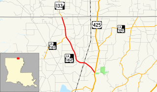
| Description | Map of Louisiana Highway 142 |
| Date | |
| Source | Own work, data from U.S. Census Bureau |
| Author | Mr. Matté (if there is an issue with this image, contact me using this image's Commons talk page, my Commons user talk page, or my English Wikipedia user talk page; I'll know about it a lot faster) |
| SVG development |
Licensing
I, the copyright holder of this work, hereby publish it under the following licenses:
|
|
Permission is granted to copy, distribute and/or modify this document under the terms of the GNU Free Documentation License, Version 1.2 or any later version published by the Free Software Foundation; with no Invariant Sections, no Front-Cover Texts, and no Back-Cover Texts. A copy of the license is included in the section entitled GNU Free Documentation License. |
This file is licensed under the
Creative Commons Attribution-Share Alike
3.0 Unported,
2.5 Generic,
2.0 Generic and
1.0 Generic license.
- You are free:
- to share – to copy, distribute and transmit the work
- to remix – to adapt the work
- Under the following conditions:
- attribution – You must give appropriate credit, provide a link to the license, and indicate if changes were made. You may do so in any reasonable manner, but not in any way that suggests the licensor endorses you or your use.
- share alike – If you remix, transform, or build upon the material, you must distribute your contributions under the same or compatible license as the original.
You may select the license of your choice.
File history
Click on a date/time to view the file as it appeared at that time.
| Date/Time | Thumbnail | Dimensions | User | Comment | |
|---|---|---|---|---|---|
| current | 01:19, 30 November 2014 |
| 1,205 × 709 (347 KB) | Mr. Matté | Fix clone fill issue |
| 01:16, 30 November 2014 |
| 1,205 × 709 (342 KB) | Mr. Matté | =={{int:filedesc}}== {{Information |Description=Map of w:Louisiana Highway 142 |Source={{own}}, data from [http://www.census.gov/cgi-bin/geo/shapefiles2012/main U.S. Census Bureau] {{inkscape}} {{QGIS}} |Date=2014-11-29 |Author={{User:Mr. Matté/A... |
File usage
The following pages on the English Wikipedia use this file (pages on other projects are not listed):
Global file usage
The following other wikis use this file:
- Usage on www.wikidata.org