
Size of this PNG preview of this SVG file:
455 × 289 pixels. Other resolutions:
320 × 203 pixels |
640 × 407 pixels |
1,024 × 650 pixels |
1,280 × 813 pixels |
2,560 × 1,626 pixels.
Original file (SVG file, nominally 455 × 289 pixels, file size: 188 KB)
| This is a file from the
Wikimedia Commons. Information from its
description page there is shown below. Commons is a freely licensed media file repository. You can help. |
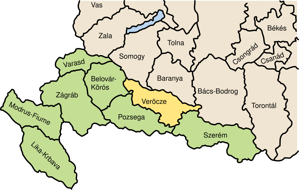
| Description | historical county locator, Verocze, Hungary | ||
| Date | |||
| Source | Own work | ||
| Author | User:IMeowbot | ||
| Permission ( Reusing this file) |
|
File history
Click on a date/time to view the file as it appeared at that time.
| Date/Time | Thumbnail | Dimensions | User | Comment | |
|---|---|---|---|---|---|
| current | 21:45, 30 April 2006 |
| 455 × 289 (188 KB) | IMeowbot~commonswiki | {{Information| |Description= historical county locator, Verocze, Hungary |Source=self made |Date=April 30, 2006 |Author= User:IMeowbot |Permission={{PD-release}} |other_versions= }} Category:Historical maps of Croatia [[Category:Historical maps of |
File usage
The following pages on the English Wikipedia use this file (pages on other projects are not listed):
Global file usage
The following other wikis use this file:
- Usage on de.wikipedia.org
- Usage on el.wikipedia.org
- Usage on eo.wikipedia.org
- Usage on es.wikipedia.org
- Usage on fr.wikipedia.org
- Usage on hr.wikipedia.org
- Usage on hu.wikipedia.org
- Usage on it.wikipedia.org
- Usage on nl.wikipedia.org
- Usage on pl.wikipedia.org
- Usage on ro.wikipedia.org
- Usage on sh.wikipedia.org
- Usage on sk.wikipedia.org
- Usage on sr.wikipedia.org
- Usage on uk.wikipedia.org
Size of this PNG preview of this SVG file:
455 × 289 pixels. Other resolutions:
320 × 203 pixels |
640 × 407 pixels |
1,024 × 650 pixels |
1,280 × 813 pixels |
2,560 × 1,626 pixels.
Original file (SVG file, nominally 455 × 289 pixels, file size: 188 KB)
| This is a file from the
Wikimedia Commons. Information from its
description page there is shown below. Commons is a freely licensed media file repository. You can help. |
| Description | historical county locator, Verocze, Hungary | ||
| Date | |||
| Source | Own work | ||
| Author | User:IMeowbot | ||
| Permission ( Reusing this file) |
|
File history
Click on a date/time to view the file as it appeared at that time.
| Date/Time | Thumbnail | Dimensions | User | Comment | |
|---|---|---|---|---|---|
| current | 21:45, 30 April 2006 |
| 455 × 289 (188 KB) | IMeowbot~commonswiki | {{Information| |Description= historical county locator, Verocze, Hungary |Source=self made |Date=April 30, 2006 |Author= User:IMeowbot |Permission={{PD-release}} |other_versions= }} Category:Historical maps of Croatia [[Category:Historical maps of |
File usage
The following pages on the English Wikipedia use this file (pages on other projects are not listed):
Global file usage
The following other wikis use this file:
- Usage on de.wikipedia.org
- Usage on el.wikipedia.org
- Usage on eo.wikipedia.org
- Usage on es.wikipedia.org
- Usage on fr.wikipedia.org
- Usage on hr.wikipedia.org
- Usage on hu.wikipedia.org
- Usage on it.wikipedia.org
- Usage on nl.wikipedia.org
- Usage on pl.wikipedia.org
- Usage on ro.wikipedia.org
- Usage on sh.wikipedia.org
- Usage on sk.wikipedia.org
- Usage on sr.wikipedia.org
- Usage on uk.wikipedia.org