
Original file (850 × 638 pixels, file size: 80 KB, MIME type: image/jpeg)
| This is a file from the
Wikimedia Commons. Information from its
description page there is shown below. Commons is a freely licensed media file repository. You can help. |
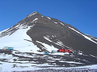
View from the central hut at the Fossil Bluff station, Alexander Island near Antarctica
First uploaded by en:User:Apacheeng lead at en:Image:Kg hut new view.jpg Taken by author whilst at fossil bluff in season 03/04 (Dec 03)
| Camera location |
| View this and other nearby images on: OpenStreetMap |
|
|---|
| |
This work has been released into the
public domain by its author,
Apacheeng lead, at the
English Wikipedia project. This applies worldwide. In case this is not legally possible: |
File history
Click on a date/time to view the file as it appeared at that time.
| Date/Time | Thumbnail | Dimensions | User | Comment | |
|---|---|---|---|---|---|
| current | 23:36, 7 May 2006 |
| 850 × 638 (80 KB) | Hardscarf | The central hut at the Fossil Bluff station, Alexander Island near Antarctica First uploaded by en:User:Apacheeng lead at en:Image:Image:Kg hut new view.jpg Taken by author whilst at fossil bluff in season 03/04 (Dec 03) Tagged as PD-old {{PD |
File usage
Global file usage
The following other wikis use this file:
- Usage on ast.wikipedia.org
- Usage on ca.wikipedia.org
- Usage on ceb.wikipedia.org
- Usage on de.wikipedia.org
- Usage on eo.wikipedia.org
- Usage on es.wikipedia.org
- Usage on gl.wikipedia.org
- Usage on he.wikipedia.org
- Usage on hi.wikipedia.org
- Usage on hr.wikipedia.org
- Usage on hu.wikipedia.org
- Usage on id.wikipedia.org
- Usage on kn.wikipedia.org
- Usage on la.wikipedia.org
- Usage on lld.wikipedia.org
- Usage on lv.wikipedia.org
- Usage on ml.wikipedia.org
- Usage on nl.wikipedia.org
- Usage on nn.wikipedia.org
- Usage on pl.wikipedia.org
- Usage on sr.wikipedia.org
- Usage on www.wikidata.org
- Usage on zh.wikipedia.org
Metadata
Original file (850 × 638 pixels, file size: 80 KB, MIME type: image/jpeg)
| This is a file from the
Wikimedia Commons. Information from its
description page there is shown below. Commons is a freely licensed media file repository. You can help. |
View from the central hut at the Fossil Bluff station, Alexander Island near Antarctica
First uploaded by en:User:Apacheeng lead at en:Image:Kg hut new view.jpg Taken by author whilst at fossil bluff in season 03/04 (Dec 03)
| Camera location |
| View this and other nearby images on: OpenStreetMap |
|
|---|
| |
This work has been released into the
public domain by its author,
Apacheeng lead, at the
English Wikipedia project. This applies worldwide. In case this is not legally possible: |
File history
Click on a date/time to view the file as it appeared at that time.
| Date/Time | Thumbnail | Dimensions | User | Comment | |
|---|---|---|---|---|---|
| current | 23:36, 7 May 2006 |
| 850 × 638 (80 KB) | Hardscarf | The central hut at the Fossil Bluff station, Alexander Island near Antarctica First uploaded by en:User:Apacheeng lead at en:Image:Image:Kg hut new view.jpg Taken by author whilst at fossil bluff in season 03/04 (Dec 03) Tagged as PD-old {{PD |
File usage
Global file usage
The following other wikis use this file:
- Usage on ast.wikipedia.org
- Usage on ca.wikipedia.org
- Usage on ceb.wikipedia.org
- Usage on de.wikipedia.org
- Usage on eo.wikipedia.org
- Usage on es.wikipedia.org
- Usage on gl.wikipedia.org
- Usage on he.wikipedia.org
- Usage on hi.wikipedia.org
- Usage on hr.wikipedia.org
- Usage on hu.wikipedia.org
- Usage on id.wikipedia.org
- Usage on kn.wikipedia.org
- Usage on la.wikipedia.org
- Usage on lld.wikipedia.org
- Usage on lv.wikipedia.org
- Usage on ml.wikipedia.org
- Usage on nl.wikipedia.org
- Usage on nn.wikipedia.org
- Usage on pl.wikipedia.org
- Usage on sr.wikipedia.org
- Usage on www.wikidata.org
- Usage on zh.wikipedia.org