Size of this preview:
413 × 599 pixels. Other resolutions:
165 × 240 pixels |
563 × 816 pixels.
Original file (563 × 816 pixels, file size: 183 KB, MIME type: image/jpeg)
| This is a file from the
Wikimedia Commons. Information from its
description page there is shown below. Commons is a freely licensed media file repository. You can help. |
Summary
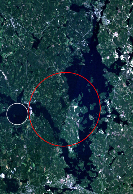
| Description | Landsat 7 satellite image of the Keurusselkä lake region. Keurusselkä impact structure is marked with a red ellipse, suggested impact structure of Ukonselkä is marked with a white circle |
| Date | 6 May 2006, 20:36:52 (according to Exif data) |
| Source | NASA WorldWind; data based on J. Moilanen's map [1] and the SEIS database [2] |
| Author | NASA |
| Permission ( Reusing this file) |
NASA PD |
Licensing
| This image is in the
public domain because it is a screenshot from
NASA’s globe software
World Wind using a public domain layer, such as Blue Marble, MODIS, Landsat, SRTM, USGS or GLOBE.
|
 |
File history
Click on a date/time to view the file as it appeared at that time.
| Date/Time | Thumbnail | Dimensions | User | Comment | |
|---|---|---|---|---|---|
| current | 17:45, 6 May 2006 |
| 563 × 816 (183 KB) | Jyril | {{Information| |Description=Landsat 7 satellite image of the Keurusselkä lake region. Keurusselkä impact structure has been marked with red circle, suggested impact structure of Ukonselkä is marked with white circle |Source=NASA WorldWind; data based o |
File usage
The following pages on the English Wikipedia use this file (pages on other projects are not listed):
Global file usage
The following other wikis use this file:
- Usage on arz.wikipedia.org
- Usage on ceb.wikipedia.org
- Usage on de.wikipedia.org
- Usage on eo.wikipedia.org
- Usage on es.wikipedia.org
- Usage on fi.wikipedia.org
- Usage on fr.wikipedia.org
- Usage on nn.wikipedia.org
- Usage on no.wikipedia.org
- Usage on pl.wikipedia.org
- Usage on ru.wikipedia.org
- Usage on sv.wikipedia.org
- Usage on uk.wikipedia.org
- Usage on www.wikidata.org
- Usage on zh.wikipedia.org
Metadata
Size of this preview:
413 × 599 pixels. Other resolutions:
165 × 240 pixels |
563 × 816 pixels.
Original file (563 × 816 pixels, file size: 183 KB, MIME type: image/jpeg)
| This is a file from the
Wikimedia Commons. Information from its
description page there is shown below. Commons is a freely licensed media file repository. You can help. |
Summary
| Description | Landsat 7 satellite image of the Keurusselkä lake region. Keurusselkä impact structure is marked with a red ellipse, suggested impact structure of Ukonselkä is marked with a white circle |
| Date | 6 May 2006, 20:36:52 (according to Exif data) |
| Source | NASA WorldWind; data based on J. Moilanen's map [1] and the SEIS database [2] |
| Author | NASA |
| Permission ( Reusing this file) |
NASA PD |
Licensing
| This image is in the
public domain because it is a screenshot from
NASA’s globe software
World Wind using a public domain layer, such as Blue Marble, MODIS, Landsat, SRTM, USGS or GLOBE.
|
|
File history
Click on a date/time to view the file as it appeared at that time.
| Date/Time | Thumbnail | Dimensions | User | Comment | |
|---|---|---|---|---|---|
| current | 17:45, 6 May 2006 |
| 563 × 816 (183 KB) | Jyril | {{Information| |Description=Landsat 7 satellite image of the Keurusselkä lake region. Keurusselkä impact structure has been marked with red circle, suggested impact structure of Ukonselkä is marked with white circle |Source=NASA WorldWind; data based o |
File usage
The following pages on the English Wikipedia use this file (pages on other projects are not listed):
Global file usage
The following other wikis use this file:
- Usage on arz.wikipedia.org
- Usage on ceb.wikipedia.org
- Usage on de.wikipedia.org
- Usage on eo.wikipedia.org
- Usage on es.wikipedia.org
- Usage on fi.wikipedia.org
- Usage on fr.wikipedia.org
- Usage on nn.wikipedia.org
- Usage on no.wikipedia.org
- Usage on pl.wikipedia.org
- Usage on ru.wikipedia.org
- Usage on sv.wikipedia.org
- Usage on uk.wikipedia.org
- Usage on www.wikidata.org
- Usage on zh.wikipedia.org