Size of this preview:
798 × 600 pixels. Other resolutions:
320 × 240 pixels |
639 × 480 pixels |
1,022 × 768 pixels |
1,131 × 850 pixels.
Original file (1,131 × 850 pixels, file size: 459 KB, MIME type: image/jpeg)
| This is a file from the
Wikimedia Commons. Information from its
description page there is shown below. Commons is a freely licensed media file repository. You can help. |
Summary
| Description |
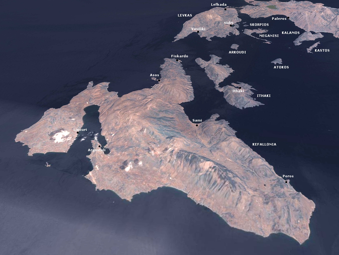
English: The Greek islands Kephalonia and Ithaka, produced with NASA World Wind |
| Date | 31 July 2006 (upload date) |
| Source | Taken from NASA World Wind software (by screenshot) |
| Author | NASA / User:AlMare |
Licensing
| This image is in the
public domain because it is a screenshot from
NASA’s globe software
World Wind using a public domain layer, such as Blue Marble, MODIS, Landsat, SRTM, USGS or GLOBE.
|
 |
| I, the copyright holder of this work, release this work into the
public domain. This applies worldwide. In some countries this may not be legally possible; if so: I grant anyone the right to use this work for any purpose, without any conditions, unless such conditions are required by law. |
File history
Click on a date/time to view the file as it appeared at that time.
| Date/Time | Thumbnail | Dimensions | User | Comment | |
|---|---|---|---|---|---|
| current | 18:37, 31 July 2006 |
| 1,131 × 850 (459 KB) | AlMare | The Greek islands Kephalonia and Ithaka, produced with NASA World Wind {{PD-WorldWind}} {{PD-self}} Category:Maps of Greece Category:Satellite images of islands Category:Satellite pictures of Greece Category:Kefalonia [[Category:Ithaka |
File usage
The following pages on the English Wikipedia use this file (pages on other projects are not listed):
Global file usage
The following other wikis use this file:
- Usage on ab.wikipedia.org
- Usage on be.wikipedia.org
- Usage on bg.wikipedia.org
- Usage on ca.wikipedia.org
- Usage on ceb.wikipedia.org
- Usage on es.wikipedia.org
- Usage on fi.wikipedia.org
- Usage on fr.wikipedia.org
- Usage on hy.wikipedia.org
- Usage on it.wikipedia.org
- Usage on ja.wikipedia.org
- Usage on nl.wikipedia.org
- Usage on pl.wikipedia.org
- Usage on pt.wikipedia.org
- Usage on ru.wikipedia.org
- Usage on sh.wikipedia.org
- Usage on sl.wikipedia.org
- Usage on uk.wikipedia.org
- Usage on www.wikidata.org
Size of this preview:
798 × 600 pixels. Other resolutions:
320 × 240 pixels |
639 × 480 pixels |
1,022 × 768 pixels |
1,131 × 850 pixels.
Original file (1,131 × 850 pixels, file size: 459 KB, MIME type: image/jpeg)
| This is a file from the
Wikimedia Commons. Information from its
description page there is shown below. Commons is a freely licensed media file repository. You can help. |
Summary
| Description |
English: The Greek islands Kephalonia and Ithaka, produced with NASA World Wind |
| Date | 31 July 2006 (upload date) |
| Source | Taken from NASA World Wind software (by screenshot) |
| Author | NASA / User:AlMare |
Licensing
| This image is in the
public domain because it is a screenshot from
NASA’s globe software
World Wind using a public domain layer, such as Blue Marble, MODIS, Landsat, SRTM, USGS or GLOBE.
|
|
| I, the copyright holder of this work, release this work into the
public domain. This applies worldwide. In some countries this may not be legally possible; if so: I grant anyone the right to use this work for any purpose, without any conditions, unless such conditions are required by law. |
File history
Click on a date/time to view the file as it appeared at that time.
| Date/Time | Thumbnail | Dimensions | User | Comment | |
|---|---|---|---|---|---|
| current | 18:37, 31 July 2006 |
| 1,131 × 850 (459 KB) | AlMare | The Greek islands Kephalonia and Ithaka, produced with NASA World Wind {{PD-WorldWind}} {{PD-self}} Category:Maps of Greece Category:Satellite images of islands Category:Satellite pictures of Greece Category:Kefalonia [[Category:Ithaka |
File usage
The following pages on the English Wikipedia use this file (pages on other projects are not listed):
Global file usage
The following other wikis use this file:
- Usage on ab.wikipedia.org
- Usage on be.wikipedia.org
- Usage on bg.wikipedia.org
- Usage on ca.wikipedia.org
- Usage on ceb.wikipedia.org
- Usage on es.wikipedia.org
- Usage on fi.wikipedia.org
- Usage on fr.wikipedia.org
- Usage on hy.wikipedia.org
- Usage on it.wikipedia.org
- Usage on ja.wikipedia.org
- Usage on nl.wikipedia.org
- Usage on pl.wikipedia.org
- Usage on pt.wikipedia.org
- Usage on ru.wikipedia.org
- Usage on sh.wikipedia.org
- Usage on sl.wikipedia.org
- Usage on uk.wikipedia.org
- Usage on www.wikidata.org