Photos • Location


Size of this preview:
800 × 600 pixels. Other resolutions:
320 × 240 pixels |
640 × 480 pixels |
1,024 × 768 pixels |
1,280 × 960 pixels |
1,600 × 1,200 pixels.
Original file (1,600 × 1,200 pixels, file size: 705 KB, MIME type: image/jpeg)
| This is a file from the
Wikimedia Commons. Information from its
description page there is shown below. Commons is a freely licensed media file repository. You can help. |
Summary
| Description |
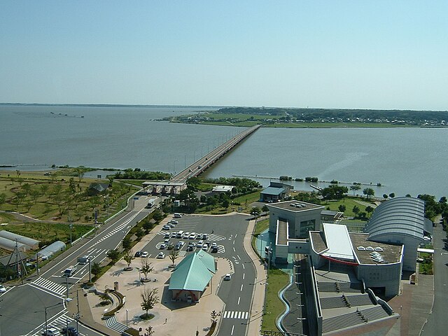
English: This is a photograph of Kasumigaura Bridge at the time of 2:45 pm, 3rd July 2004. Shot from Nijinotou Tower at Kasumigaura Fureai Land Park, near by the bridge. At that time, there had been a tollbooth (left lower).
日本語: 料金所が存在した頃の霞ヶ浦大橋の全景。2004年7月3日午後2時45分に、隣接する霞ヶ浦ふれあいランドの虹の塔の最上階より撮影。左下に料金所が見える。 |
| Date | |
| Source | Own shot 自身による撮影 |
| Author | tu-ka-pon |
| Camera location |
| View this and other nearby images on: OpenStreetMap |
|
|---|
Licensing
| I, the copyright holder of this work, release this work into the
public domain. This applies worldwide. In some countries this may not be legally possible; if so: I grant anyone the right to use this work for any purpose, without any conditions, unless such conditions are required by law. |
File history
Click on a date/time to view the file as it appeared at that time.
| Date/Time | Thumbnail | Dimensions | User | Comment | |
|---|---|---|---|---|---|
| current | 17:13, 8 January 2010 |
| 1,600 × 1,200 (705 KB) | Tu-ka-pon | {{Information |Description={{en|1=This is a photograph of Kasumigaura Bridge at the time of 2:45 pm, 3rd July 2004. Shot from Nijinotou Tower at Kasumigaura Fureai Land Park, near by the bridge. At that time, there had been a tollbooth (left lower).}} {{j |
File usage
The following pages on the English Wikipedia use this file (pages on other projects are not listed):
Global file usage
The following other wikis use this file:
- Usage on de.wikipedia.org
- Usage on es.wikipedia.org
- Usage on fr.wikipedia.org
- Usage on ja.wikipedia.org
- Usage on uz.wikipedia.org
- Usage on war.wikipedia.org
Metadata
Size of this preview:
800 × 600 pixels. Other resolutions:
320 × 240 pixels |
640 × 480 pixels |
1,024 × 768 pixels |
1,280 × 960 pixels |
1,600 × 1,200 pixels.
Original file (1,600 × 1,200 pixels, file size: 705 KB, MIME type: image/jpeg)
| This is a file from the
Wikimedia Commons. Information from its
description page there is shown below. Commons is a freely licensed media file repository. You can help. |
Summary
| Description |
English: This is a photograph of Kasumigaura Bridge at the time of 2:45 pm, 3rd July 2004. Shot from Nijinotou Tower at Kasumigaura Fureai Land Park, near by the bridge. At that time, there had been a tollbooth (left lower).
日本語: 料金所が存在した頃の霞ヶ浦大橋の全景。2004年7月3日午後2時45分に、隣接する霞ヶ浦ふれあいランドの虹の塔の最上階より撮影。左下に料金所が見える。 |
| Date | |
| Source | Own shot 自身による撮影 |
| Author | tu-ka-pon |
| Camera location |
| View this and other nearby images on: OpenStreetMap |
|
|---|
Licensing
| I, the copyright holder of this work, release this work into the
public domain. This applies worldwide. In some countries this may not be legally possible; if so: I grant anyone the right to use this work for any purpose, without any conditions, unless such conditions are required by law. |
File history
Click on a date/time to view the file as it appeared at that time.
| Date/Time | Thumbnail | Dimensions | User | Comment | |
|---|---|---|---|---|---|
| current | 17:13, 8 January 2010 |
| 1,600 × 1,200 (705 KB) | Tu-ka-pon | {{Information |Description={{en|1=This is a photograph of Kasumigaura Bridge at the time of 2:45 pm, 3rd July 2004. Shot from Nijinotou Tower at Kasumigaura Fureai Land Park, near by the bridge. At that time, there had been a tollbooth (left lower).}} {{j |
File usage
The following pages on the English Wikipedia use this file (pages on other projects are not listed):
Global file usage
The following other wikis use this file:
- Usage on de.wikipedia.org
- Usage on es.wikipedia.org
- Usage on fr.wikipedia.org
- Usage on ja.wikipedia.org
- Usage on uz.wikipedia.org
- Usage on war.wikipedia.org