
Size of this PNG preview of this SVG file:
423 × 600 pixels. Other resolutions:
169 × 240 pixels |
338 × 480 pixels |
542 × 768 pixels |
722 × 1,024 pixels |
1,445 × 2,048 pixels |
898 × 1,273 pixels.
Original file (SVG file, nominally 898 × 1,273 pixels, file size: 937 KB)
| This is a file from the
Wikimedia Commons. Information from its
description page there is shown below. Commons is a freely licensed media file repository. You can help. |
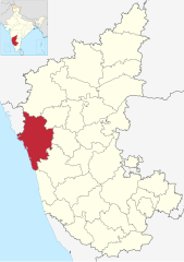
| Description | Location map of Uttara Kannada district in Karnataka. |
| Date | (UTC) |
| Source | |
| Author |
|
| This is a
retouched picture, which means that it has been digitally altered from its original version. Modifications: Highlighted Uttara Kannada district. The original can be viewed here:
India Karnataka location map.svg:
|
This file is licensed under the
Creative Commons
Attribution-Share Alike 3.0 Unported license.
- You are free:
- to share – to copy, distribute and transmit the work
- to remix – to adapt the work
- Under the following conditions:
- attribution – You must give appropriate credit, provide a link to the license, and indicate if changes were made. You may do so in any reasonable manner, but not in any way that suggests the licensor endorses you or your use.
- share alike – If you remix, transform, or build upon the material, you must distribute your contributions under the same or compatible license as the original.
Original upload log
This image is a derivative work of the following images:
-
File:India_Karnataka_location_map.svg licensed with Cc-by-sa-3.0
- 2010-11-15T15:50:48Z Nayvik 1630x2356 (211689 Bytes) Changed background color
- 2010-11-15T15:34:13Z Nayvik 1630x2356 (211293 Bytes) {{Information |Description=Location map of [[:en:Karnataka|Karnataka]] Geographic limits of the map: * 18.5°N * 11.0°N * 73.6°E * 78.7°E |Source=*[[:File:Karnataka_locator_map.svg|]], [http://www.censusindia.gov.in/2011-I
Uploaded with derivativeFX
File history
Click on a date/time to view the file as it appeared at that time.
| Date/Time | Thumbnail | Dimensions | User | Comment | |
|---|---|---|---|---|---|
| current | 03:37, 16 June 2023 |
| 898 × 1,273 (937 KB) | C1MM | updated bounds |
| 03:49, 16 July 2021 |
 | 851 × 1,211 (1.05 MB) | C1MM | c bounds | |
| 17:44, 20 November 2010 |
 | 1,630 × 2,356 (207 KB) | Nayvik | {{Information |Description=Location map of Uttara Kannada district in Karnataka. |Source=* File:India_Karnataka_location_map.svg |Date=2010-11-20 17:43 (UTC) |Author=* File:India_Karnataka_location_map.svg: *[[:Fi |
File usage
The following pages on the English Wikipedia use this file (pages on other projects are not listed):
Global file usage
The following other wikis use this file:
- Usage on ar.wikipedia.org
- Usage on arz.wikipedia.org
- Usage on azb.wikipedia.org
- Usage on bh.wikipedia.org
- Usage on bn.wikipedia.org
- Usage on ca.wikipedia.org
- Usage on de.wikipedia.org
- Usage on es.wikipedia.org
- Usage on eu.wikipedia.org
- Usage on fa.wikipedia.org
- Usage on fr.wikipedia.org
- Usage on hi.wikipedia.org
- Usage on id.wikipedia.org
- Usage on it.wikipedia.org
- Usage on kn.wikipedia.org
- Usage on ml.wikipedia.org
- Usage on mr.wikipedia.org
- Usage on nl.wikipedia.org
- Usage on no.wikipedia.org
- Usage on oc.wikipedia.org
- Usage on pl.wikipedia.org
- Usage on ru.wikipedia.org
- Usage on sat.wikipedia.org
- Usage on sa.wikipedia.org
View more global usage of this file.
Metadata
Size of this PNG preview of this SVG file:
423 × 600 pixels. Other resolutions:
169 × 240 pixels |
338 × 480 pixels |
542 × 768 pixels |
722 × 1,024 pixels |
1,445 × 2,048 pixels |
898 × 1,273 pixels.
Original file (SVG file, nominally 898 × 1,273 pixels, file size: 937 KB)
| This is a file from the
Wikimedia Commons. Information from its
description page there is shown below. Commons is a freely licensed media file repository. You can help. |
| Description | Location map of Uttara Kannada district in Karnataka. |
| Date | (UTC) |
| Source | |
| Author |
|
| This is a
retouched picture, which means that it has been digitally altered from its original version. Modifications: Highlighted Uttara Kannada district. The original can be viewed here:
India Karnataka location map.svg:
|
This file is licensed under the
Creative Commons
Attribution-Share Alike 3.0 Unported license.
- You are free:
- to share – to copy, distribute and transmit the work
- to remix – to adapt the work
- Under the following conditions:
- attribution – You must give appropriate credit, provide a link to the license, and indicate if changes were made. You may do so in any reasonable manner, but not in any way that suggests the licensor endorses you or your use.
- share alike – If you remix, transform, or build upon the material, you must distribute your contributions under the same or compatible license as the original.
Original upload log
This image is a derivative work of the following images:
-
File:India_Karnataka_location_map.svg licensed with Cc-by-sa-3.0
- 2010-11-15T15:50:48Z Nayvik 1630x2356 (211689 Bytes) Changed background color
- 2010-11-15T15:34:13Z Nayvik 1630x2356 (211293 Bytes) {{Information |Description=Location map of [[:en:Karnataka|Karnataka]] Geographic limits of the map: * 18.5°N * 11.0°N * 73.6°E * 78.7°E |Source=*[[:File:Karnataka_locator_map.svg|]], [http://www.censusindia.gov.in/2011-I
Uploaded with derivativeFX
File history
Click on a date/time to view the file as it appeared at that time.
| Date/Time | Thumbnail | Dimensions | User | Comment | |
|---|---|---|---|---|---|
| current | 03:37, 16 June 2023 |
| 898 × 1,273 (937 KB) | C1MM | updated bounds |
| 03:49, 16 July 2021 |
| 851 × 1,211 (1.05 MB) | C1MM | c bounds | |
| 17:44, 20 November 2010 |
| 1,630 × 2,356 (207 KB) | Nayvik | {{Information |Description=Location map of Uttara Kannada district in Karnataka. |Source=* File:India_Karnataka_location_map.svg |Date=2010-11-20 17:43 (UTC) |Author=* File:India_Karnataka_location_map.svg: *[[:Fi |
File usage
The following pages on the English Wikipedia use this file (pages on other projects are not listed):
Global file usage
The following other wikis use this file:
- Usage on ar.wikipedia.org
- Usage on arz.wikipedia.org
- Usage on azb.wikipedia.org
- Usage on bh.wikipedia.org
- Usage on bn.wikipedia.org
- Usage on ca.wikipedia.org
- Usage on de.wikipedia.org
- Usage on es.wikipedia.org
- Usage on eu.wikipedia.org
- Usage on fa.wikipedia.org
- Usage on fr.wikipedia.org
- Usage on hi.wikipedia.org
- Usage on id.wikipedia.org
- Usage on it.wikipedia.org
- Usage on kn.wikipedia.org
- Usage on ml.wikipedia.org
- Usage on mr.wikipedia.org
- Usage on nl.wikipedia.org
- Usage on no.wikipedia.org
- Usage on oc.wikipedia.org
- Usage on pl.wikipedia.org
- Usage on ru.wikipedia.org
- Usage on sat.wikipedia.org
- Usage on sa.wikipedia.org
View more global usage of this file.