
Size of this preview:
468 × 599 pixels. Other resolutions:
187 × 240 pixels |
375 × 480 pixels |
600 × 768 pixels |
1,059 × 1,356 pixels.
Original file (1,059 × 1,356 pixels, file size: 1.19 MB, MIME type: image/jpeg)
| This is a file from the
Wikimedia Commons. Information from its
description page there is shown below. Commons is a freely licensed media file repository. You can help. |
Summary
| Description |
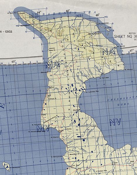
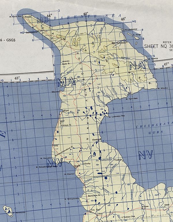
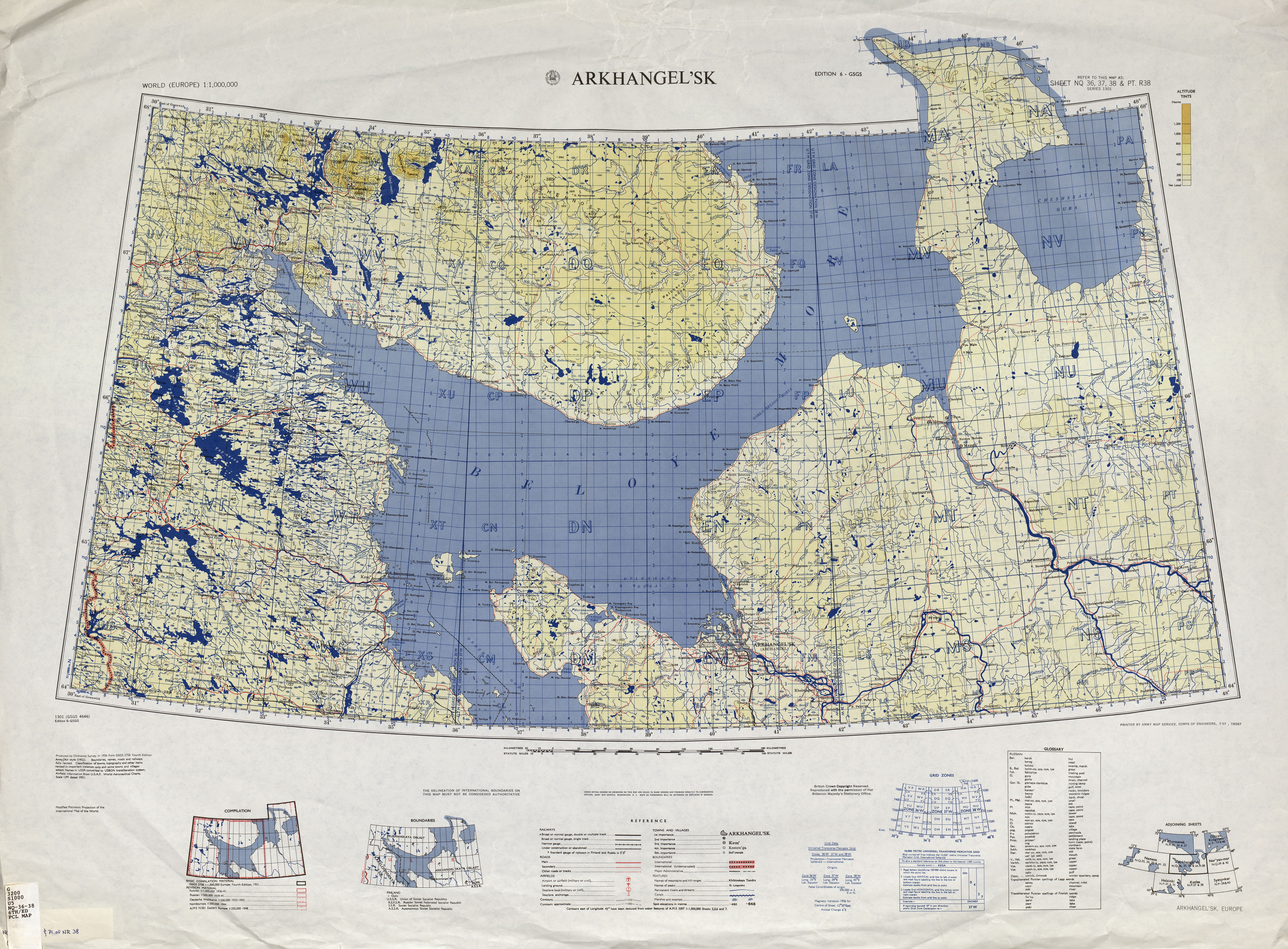
English: map of Kanin peninsula, Russia |
| Date | |
| Source | http://www.lib.utexas.edu/maps/imw/txu-oclc-6654394-nq-36-38-6th-ed.jpg |
| Author | Army Map Service |
Licensing
This file is a work of a
U.S. Army soldier or employee, taken or made as part of that person's official duties. As a
work of the
U.S. federal government, it is in the
public domain in the United States.
|
 |
File history
Click on a date/time to view the file as it appeared at that time.
| Date/Time | Thumbnail | Dimensions | User | Comment | |
|---|---|---|---|---|---|
| current | 14:44, 3 April 2010 |
| 1,059 × 1,356 (1.19 MB) | Ratzer | {{Information |Description={{en|1=map of Kanin peninsula, Russia}} |Source=http://www.lib.utexas.edu/maps/imw/txu-oclc-6654394-nq-36-38-6th-ed.jpg |Author=Army Map Service |Date=1956 |Permission= |other_versions= }} Category:Maps of Murmansk Oblast |
File usage
The following pages on the English Wikipedia use this file (pages on other projects are not listed):
Global file usage
The following other wikis use this file:
- Usage on ar.wikipedia.org
- Usage on az.wikipedia.org
- Usage on ceb.wikipedia.org
- Usage on cs.wikipedia.org
- Usage on cy.wikipedia.org
- Usage on de.wikipedia.org
- Usage on fa.wikipedia.org
- Usage on fr.wikipedia.org
- Usage on hy.wikipedia.org
- Usage on it.wikipedia.org
- Usage on ko.wikipedia.org
- Usage on no.wikipedia.org
- Usage on pl.wikipedia.org
- Usage on pt.wikipedia.org
- Usage on ru.wikipedia.org
- Usage on uk.wikipedia.org
- Usage on www.wikidata.org
Metadata
Size of this preview:
468 × 599 pixels. Other resolutions:
187 × 240 pixels |
375 × 480 pixels |
600 × 768 pixels |
1,059 × 1,356 pixels.
Original file (1,059 × 1,356 pixels, file size: 1.19 MB, MIME type: image/jpeg)
| This is a file from the
Wikimedia Commons. Information from its
description page there is shown below. Commons is a freely licensed media file repository. You can help. |
Summary
| Description |
English: map of Kanin peninsula, Russia |
| Date | |
| Source | http://www.lib.utexas.edu/maps/imw/txu-oclc-6654394-nq-36-38-6th-ed.jpg |
| Author | Army Map Service |
Licensing
This file is a work of a
U.S. Army soldier or employee, taken or made as part of that person's official duties. As a
work of the
U.S. federal government, it is in the
public domain in the United States.
|
|
File history
Click on a date/time to view the file as it appeared at that time.
| Date/Time | Thumbnail | Dimensions | User | Comment | |
|---|---|---|---|---|---|
| current | 14:44, 3 April 2010 |
| 1,059 × 1,356 (1.19 MB) | Ratzer | {{Information |Description={{en|1=map of Kanin peninsula, Russia}} |Source=http://www.lib.utexas.edu/maps/imw/txu-oclc-6654394-nq-36-38-6th-ed.jpg |Author=Army Map Service |Date=1956 |Permission= |other_versions= }} Category:Maps of Murmansk Oblast |
File usage
The following pages on the English Wikipedia use this file (pages on other projects are not listed):
Global file usage
The following other wikis use this file:
- Usage on ar.wikipedia.org
- Usage on az.wikipedia.org
- Usage on ceb.wikipedia.org
- Usage on cs.wikipedia.org
- Usage on cy.wikipedia.org
- Usage on de.wikipedia.org
- Usage on fa.wikipedia.org
- Usage on fr.wikipedia.org
- Usage on hy.wikipedia.org
- Usage on it.wikipedia.org
- Usage on ko.wikipedia.org
- Usage on no.wikipedia.org
- Usage on pl.wikipedia.org
- Usage on pt.wikipedia.org
- Usage on ru.wikipedia.org
- Usage on uk.wikipedia.org
- Usage on www.wikidata.org