Photos • Location


Size of this PNG preview of this SVG file:
800 × 401 pixels. Other resolutions:
320 × 160 pixels |
640 × 321 pixels |
1,024 × 513 pixels |
1,280 × 642 pixels |
2,560 × 1,283 pixels |
848 × 425 pixels.
Original file (SVG file, nominally 848 × 425 pixels, file size: 4.98 MB)
| This is a file from the
Wikimedia Commons. Information from its
description page there is shown below. Commons is a freely licensed media file repository. You can help. |
Summary
| Camera location |
| View this and other nearby images on: OpenStreetMap |
|
|---|
| Description |
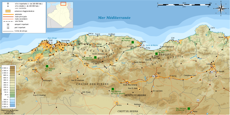
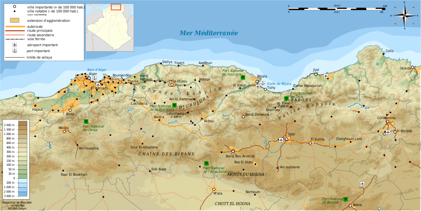
Français : Carte topographique en français de la
Kabylie
Deutsch: Topographische Karte zum
Kabylei, in Französische
English: Topographic map in French language of
Kabylie
Español: Mapa topográfico en francès de
Cabilia
Italiano: Carta topografica della
Cabilia (en francese)
日本語: フランス語で表示したKabylie(
アルジェリア)の地形地図
Português: Carta topográfica da
Cabília em francês
العربية: خريطة طبوغرافية باللغة الفرنسية
لمنطقة القبائل
|
||
| Date | (UTC) | ||
| Source |
Création personnelle ;
|
||
| Author | © Bourrichon ( talk) - fr:Bourrichon | ||
| Permission ( Reusing this file) |
|
||
| Other versions |
Add-your-version : Template:Other versions/Kabylie map
|


|
This SVG file contains embedded text that can be translated into your language, using any capable SVG editor, text editor or the SVG Translate tool. For more information see: About translating SVG files. |
This W3C-unspecified
vector image was created with
Inkscape .
Licensing
I, the copyright holder of this work, hereby publish it under the following licenses:

|
Permission is granted to copy, distribute and/or modify this document under the terms of the GNU Free Documentation License, Version 1.2 or any later version published by the Free Software Foundation; with no Invariant Sections, no Front-Cover Texts, and no Back-Cover Texts. A copy of the license is included in the section entitled GNU Free Documentation License. |
This file is licensed under the
Creative Commons Attribution-Share Alike
3.0 Unported,
2.5 Generic,
2.0 Generic and
1.0 Generic license.
- You are free:
- to share – to copy, distribute and transmit the work
- to remix – to adapt the work
- Under the following conditions:
- attribution – You must give appropriate credit, provide a link to the license, and indicate if changes were made. You may do so in any reasonable manner, but not in any way that suggests the licensor endorses you or your use.
- share alike – If you remix, transform, or build upon the material, you must distribute your contributions under the same or compatible license as the original.
You may select the license of your choice.
File history
Click on a date/time to view the file as it appeared at that time.
| Date/Time | Thumbnail | Dimensions | User | Comment | |
|---|---|---|---|---|---|
| current | 13:26, 7 September 2011 |
| 848 × 425 (4.98 MB) | Bourrichon | +Parcs nationaux |
| 13:23, 7 September 2011 |
 | 848 × 425 (4.98 MB) | Bourrichon | +Parcs nationaux | |
| 13:20, 6 September 2011 |
 | 848 × 425 (4.95 MB) | Bourrichon | Carte de localisation svg | |
| 13:08, 6 September 2011 |
 | 848 × 425 (4.85 MB) | Bourrichon | recadrage | |
| 12:59, 6 September 2011 |
 | 1,052 × 744 (5.03 MB) | Bourrichon | == {{int:filedesc}} == {{Location|36|30|00|N|03|30|00|E|scale:500000}} {{Information |Description= {{fr|Carte topographique en français de la fr:Kabylie}} {{de|Topographische Karte zum de:Kabylei, in Französische}} {{en|Topographic map in |
File usage
The following pages on the English Wikipedia use this file (pages on other projects are not listed):
Global file usage
The following other wikis use this file:
- Usage on als.wikipedia.org
- Usage on ar.wikipedia.org
- Usage on cs.wikipedia.org
- Usage on de.wikipedia.org
- Usage on de.wikiversity.org
- Usage on el.wikipedia.org
- Usage on es.wikipedia.org
- Usage on fa.wikipedia.org
- Usage on fi.wikipedia.org
- Usage on fr.wikipedia.org
- Usage on gl.wikipedia.org
- Usage on is.wikipedia.org
- Usage on it.wikipedia.org
- Usage on ja.wikipedia.org
- Usage on ro.wikipedia.org
- Usage on scn.wikipedia.org
- Usage on sv.wikipedia.org
- Usage on uk.wikipedia.org
- Usage on www.wikidata.org
Metadata
Size of this PNG preview of this SVG file:
800 × 401 pixels. Other resolutions:
320 × 160 pixels |
640 × 321 pixels |
1,024 × 513 pixels |
1,280 × 642 pixels |
2,560 × 1,283 pixels |
848 × 425 pixels.
Original file (SVG file, nominally 848 × 425 pixels, file size: 4.98 MB)
| This is a file from the
Wikimedia Commons. Information from its
description page there is shown below. Commons is a freely licensed media file repository. You can help. |
Summary
| Camera location |
| View this and other nearby images on: OpenStreetMap |
|
|---|
| Description |
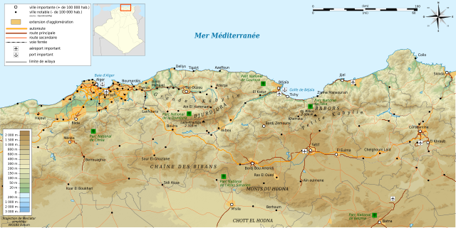
Français : Carte topographique en français de la
Kabylie
Deutsch: Topographische Karte zum
Kabylei, in Französische
English: Topographic map in French language of
Kabylie
Español: Mapa topográfico en francès de
Cabilia
Italiano: Carta topografica della
Cabilia (en francese)
日本語: フランス語で表示したKabylie(
アルジェリア)の地形地図
Português: Carta topográfica da
Cabília em francês
العربية: خريطة طبوغرافية باللغة الفرنسية
لمنطقة القبائل
|
||
| Date | (UTC) | ||
| Source |
Création personnelle ;
|
||
| Author | © Bourrichon ( talk) - fr:Bourrichon | ||
| Permission ( Reusing this file) |
|
||
| Other versions |
Add-your-version : Template:Other versions/Kabylie map
|
|
|
This SVG file contains embedded text that can be translated into your language, using any capable SVG editor, text editor or the SVG Translate tool. For more information see: About translating SVG files. |
This W3C-unspecified
vector image was created with
Inkscape .
Licensing
I, the copyright holder of this work, hereby publish it under the following licenses:
|
|
Permission is granted to copy, distribute and/or modify this document under the terms of the GNU Free Documentation License, Version 1.2 or any later version published by the Free Software Foundation; with no Invariant Sections, no Front-Cover Texts, and no Back-Cover Texts. A copy of the license is included in the section entitled GNU Free Documentation License. |
This file is licensed under the
Creative Commons Attribution-Share Alike
3.0 Unported,
2.5 Generic,
2.0 Generic and
1.0 Generic license.
- You are free:
- to share – to copy, distribute and transmit the work
- to remix – to adapt the work
- Under the following conditions:
- attribution – You must give appropriate credit, provide a link to the license, and indicate if changes were made. You may do so in any reasonable manner, but not in any way that suggests the licensor endorses you or your use.
- share alike – If you remix, transform, or build upon the material, you must distribute your contributions under the same or compatible license as the original.
You may select the license of your choice.
File history
Click on a date/time to view the file as it appeared at that time.
| Date/Time | Thumbnail | Dimensions | User | Comment | |
|---|---|---|---|---|---|
| current | 13:26, 7 September 2011 |
| 848 × 425 (4.98 MB) | Bourrichon | +Parcs nationaux |
| 13:23, 7 September 2011 |
| 848 × 425 (4.98 MB) | Bourrichon | +Parcs nationaux | |
| 13:20, 6 September 2011 |
| 848 × 425 (4.95 MB) | Bourrichon | Carte de localisation svg | |
| 13:08, 6 September 2011 |
| 848 × 425 (4.85 MB) | Bourrichon | recadrage | |
| 12:59, 6 September 2011 |
| 1,052 × 744 (5.03 MB) | Bourrichon | == {{int:filedesc}} == {{Location|36|30|00|N|03|30|00|E|scale:500000}} {{Information |Description= {{fr|Carte topographique en français de la fr:Kabylie}} {{de|Topographische Karte zum de:Kabylei, in Französische}} {{en|Topographic map in |
File usage
The following pages on the English Wikipedia use this file (pages on other projects are not listed):
Global file usage
The following other wikis use this file:
- Usage on als.wikipedia.org
- Usage on ar.wikipedia.org
- Usage on cs.wikipedia.org
- Usage on de.wikipedia.org
- Usage on de.wikiversity.org
- Usage on el.wikipedia.org
- Usage on es.wikipedia.org
- Usage on fa.wikipedia.org
- Usage on fi.wikipedia.org
- Usage on fr.wikipedia.org
- Usage on gl.wikipedia.org
- Usage on is.wikipedia.org
- Usage on it.wikipedia.org
- Usage on ja.wikipedia.org
- Usage on ro.wikipedia.org
- Usage on scn.wikipedia.org
- Usage on sv.wikipedia.org
- Usage on uk.wikipedia.org
- Usage on www.wikidata.org