
Size of this preview:
424 × 600 pixels. Other resolutions:
170 × 240 pixels |
339 × 480 pixels |
543 × 768 pixels |
724 × 1,024 pixels |
1,654 × 2,339 pixels.
Original file (1,654 × 2,339 pixels, file size: 545 KB, MIME type: image/jpeg)
| This is a file from the
Wikimedia Commons. Information from its
description page there is shown below. Commons is a freely licensed media file repository. You can help. |
Summary
| Description |
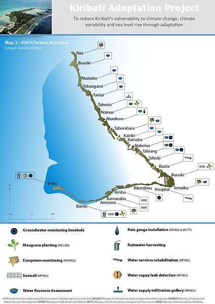
English: This map illustrates the activities that have been performed on and around Tarawa as part of phase II of the Kiribati Adaptation Program. |
| Date | |
| Source | Own work |
| Author | Marchonore |
Licensing
I, the copyright holder of this work, hereby publish it under the following license:
| This file is made available under the Creative Commons CC0 1.0 Universal Public Domain Dedication. | |
| The person who associated a work with this deed has dedicated the work to the
public domain by waiving all of their rights to the work worldwide under copyright law, including all related and neighboring rights, to the extent allowed by law. You can copy, modify, distribute and perform the work, even for commercial purposes, all without asking permission.
|
File history
Click on a date/time to view the file as it appeared at that time.
| Date/Time | Thumbnail | Dimensions | User | Comment | |
|---|---|---|---|---|---|
| current | 19:39, 5 July 2011 |
| 1,654 × 2,339 (545 KB) | Marchonore | {{Information |Description ={{en|1=This map illustrates the activities that have been performed on and around Tarawa as part of phase II of the Kiribati Adaptation Program.}} |Source ={{own}} |Author = Marchonore |Dat |
File usage
The following pages on the English Wikipedia use this file (pages on other projects are not listed):
Metadata
Size of this preview:
424 × 600 pixels. Other resolutions:
170 × 240 pixels |
339 × 480 pixels |
543 × 768 pixels |
724 × 1,024 pixels |
1,654 × 2,339 pixels.
Original file (1,654 × 2,339 pixels, file size: 545 KB, MIME type: image/jpeg)
| This is a file from the
Wikimedia Commons. Information from its
description page there is shown below. Commons is a freely licensed media file repository. You can help. |
Summary
| Description |
English: This map illustrates the activities that have been performed on and around Tarawa as part of phase II of the Kiribati Adaptation Program. |
| Date | |
| Source | Own work |
| Author | Marchonore |
Licensing
I, the copyright holder of this work, hereby publish it under the following license:
| This file is made available under the Creative Commons CC0 1.0 Universal Public Domain Dedication. | |
| The person who associated a work with this deed has dedicated the work to the
public domain by waiving all of their rights to the work worldwide under copyright law, including all related and neighboring rights, to the extent allowed by law. You can copy, modify, distribute and perform the work, even for commercial purposes, all without asking permission.
|
File history
Click on a date/time to view the file as it appeared at that time.
| Date/Time | Thumbnail | Dimensions | User | Comment | |
|---|---|---|---|---|---|
| current | 19:39, 5 July 2011 |
| 1,654 × 2,339 (545 KB) | Marchonore | {{Information |Description ={{en|1=This map illustrates the activities that have been performed on and around Tarawa as part of phase II of the Kiribati Adaptation Program.}} |Source ={{own}} |Author = Marchonore |Dat |
File usage
The following pages on the English Wikipedia use this file (pages on other projects are not listed):