
Size of this preview:
600 × 600 pixels. Other resolutions:
240 × 240 pixels |
480 × 480 pixels |
768 × 768 pixels |
1,024 × 1,024 pixels.
Original file (1,024 × 1,024 pixels, file size: 254 KB, MIME type: image/jpeg)
| This is a file from the
Wikimedia Commons. Information from its
description page there is shown below. Commons is a freely licensed media file repository. You can help. |
Summary
| Description |
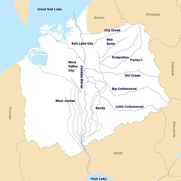
English: A map of the
Jordan River watershed, exclusive of the drainage basin surrounding Utah Lake, which also flows into the Jordan. Rivers and creeks are in blue. Canals are in gray. |
| Date | |
| Source | File created by Own work, with map from JPL OnEarth and vector data from Utah GIS Portal. |
| Author | Bgwhite |
| Other versions |
|

_Watershed.jpg)
Licensing
I, the copyright holder of this work, hereby publish it under the following license:
This file is licensed under the
Creative Commons
Attribution-Share Alike 3.0 Unported license.
- You are free:
- to share – to copy, distribute and transmit the work
- to remix – to adapt the work
- Under the following conditions:
- attribution – You must give appropriate credit, provide a link to the license, and indicate if changes were made. You may do so in any reasonable manner, but not in any way that suggests the licensor endorses you or your use.
- share alike – If you remix, transform, or build upon the material, you must distribute your contributions under the same or compatible license as the original.
File history
Click on a date/time to view the file as it appeared at that time.
| Date/Time | Thumbnail | Dimensions | User | Comment | |
|---|---|---|---|---|---|
| current | 18:03, 26 May 2010 |
| 1,024 × 1,024 (254 KB) | Bgwhite | Add updated background and fix color for Antelope Island |
| 21:00, 23 May 2010 |
 | 1,024 × 1,028 (188 KB) | Bgwhite | Change format to conform to FA standards | |
| 06:58, 14 April 2010 |
 | 1,024 × 1,280 (890 KB) | Bgwhite | {{Information |Description={{en|1=A map of the Jordan River (Utah) watershed. Rivers and creeks are in blue. Canals are in gray.}} |Source=File created by {{own}}, with map from [http://onearth.jpl.nasa.gov/ JPL OnEarth] and vector data from [http: |
File usage
The following pages on the English Wikipedia use this file (pages on other projects are not listed):
Global file usage
The following other wikis use this file:
- Usage on de.wikipedia.org
- Usage on fr.wikipedia.org
- Usage on sv.wikipedia.org
Metadata
_Watershed.jpg)
Size of this preview:
600 × 600 pixels. Other resolutions:
240 × 240 pixels |
480 × 480 pixels |
768 × 768 pixels |
1,024 × 1,024 pixels.
Original file (1,024 × 1,024 pixels, file size: 254 KB, MIME type: image/jpeg)
| This is a file from the
Wikimedia Commons. Information from its
description page there is shown below. Commons is a freely licensed media file repository. You can help. |
Summary
| Description |
English: A map of the
Jordan River watershed, exclusive of the drainage basin surrounding Utah Lake, which also flows into the Jordan. Rivers and creeks are in blue. Canals are in gray. |
| Date | |
| Source | File created by Own work, with map from JPL OnEarth and vector data from Utah GIS Portal. |
| Author | Bgwhite |
| Other versions |
|
Licensing
I, the copyright holder of this work, hereby publish it under the following license:
This file is licensed under the
Creative Commons
Attribution-Share Alike 3.0 Unported license.
- You are free:
- to share – to copy, distribute and transmit the work
- to remix – to adapt the work
- Under the following conditions:
- attribution – You must give appropriate credit, provide a link to the license, and indicate if changes were made. You may do so in any reasonable manner, but not in any way that suggests the licensor endorses you or your use.
- share alike – If you remix, transform, or build upon the material, you must distribute your contributions under the same or compatible license as the original.
File history
Click on a date/time to view the file as it appeared at that time.
| Date/Time | Thumbnail | Dimensions | User | Comment | |
|---|---|---|---|---|---|
| current | 18:03, 26 May 2010 |
| 1,024 × 1,024 (254 KB) | Bgwhite | Add updated background and fix color for Antelope Island |
| 21:00, 23 May 2010 |
| 1,024 × 1,028 (188 KB) | Bgwhite | Change format to conform to FA standards | |
| 06:58, 14 April 2010 |
| 1,024 × 1,280 (890 KB) | Bgwhite | {{Information |Description={{en|1=A map of the Jordan River (Utah) watershed. Rivers and creeks are in blue. Canals are in gray.}} |Source=File created by {{own}}, with map from [http://onearth.jpl.nasa.gov/ JPL OnEarth] and vector data from [http: |
File usage
The following pages on the English Wikipedia use this file (pages on other projects are not listed):
Global file usage
The following other wikis use this file:
- Usage on de.wikipedia.org
- Usage on fr.wikipedia.org
- Usage on sv.wikipedia.org