
Size of this preview:
788 × 600 pixels. Other resolutions:
316 × 240 pixels |
631 × 480 pixels |
1,010 × 768 pixels |
1,280 × 974 pixels |
2,560 × 1,948 pixels |
4,169 × 3,172 pixels.
Original file (4,169 × 3,172 pixels, file size: 6.37 MB, MIME type: image/jpeg)
| This is a file from the
Wikimedia Commons. Information from its
description page there is shown below. Commons is a freely licensed media file repository. You can help. |
| Description |
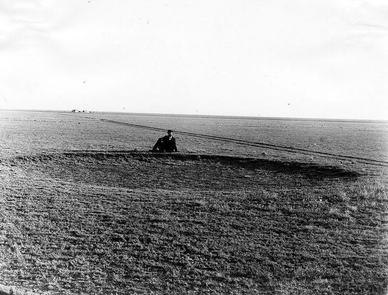
English: Appears as Plate II in: Darton, N.H. 1920. Syracuse-Lakin folio, Kansas. United States Department of the Interior, U.S. Geological Survey, Folios of the Geologic Atlas, no. 212. Original caption: Typical surface of the country underlain by the Ogallala formation of the
High Plains of western Kansas. Buffalo wallow, shallow circular depression in the level surface, in foreground. Photo date is 1897 and location is
Haskell County, Kansas. |
|||
| Date | ||||
| Source | U.S. Geological Survey Photographic Library, http://libraryphoto.cr.usgs.gov/ | |||
| Author | Willard Drake Johnson | |||
| Permission ( Reusing this file) |
|
File history
Click on a date/time to view the file as it appeared at that time.
| Date/Time | Thumbnail | Dimensions | User | Comment | |
|---|---|---|---|---|---|
| current | 21:42, 20 December 2008 |
| 4,169 × 3,172 (6.37 MB) | Leaflet | {{Information |Description={{en|1=Typical surface of the country underlain by the Ogahalla formation of the high plains of western Kansas, buffalo wallow; shallow circular depression in the level surface, in foreground. Haskell County, Kansas. 1897. Plate |
File usage
The following pages on the English Wikipedia use this file (pages on other projects are not listed):
Global file usage
The following other wikis use this file:
- Usage on arz.wikipedia.org
- Usage on ca.wikipedia.org
- Usage on he.wikipedia.org
- Usage on ja.wikipedia.org
- Usage on ka.wikipedia.org
- Usage on simple.wikipedia.org
- Usage on vi.wikipedia.org
Metadata
Size of this preview:
788 × 600 pixels. Other resolutions:
316 × 240 pixels |
631 × 480 pixels |
1,010 × 768 pixels |
1,280 × 974 pixels |
2,560 × 1,948 pixels |
4,169 × 3,172 pixels.
Original file (4,169 × 3,172 pixels, file size: 6.37 MB, MIME type: image/jpeg)
| This is a file from the
Wikimedia Commons. Information from its
description page there is shown below. Commons is a freely licensed media file repository. You can help. |
| Description |
English: Appears as Plate II in: Darton, N.H. 1920. Syracuse-Lakin folio, Kansas. United States Department of the Interior, U.S. Geological Survey, Folios of the Geologic Atlas, no. 212. Original caption: Typical surface of the country underlain by the Ogallala formation of the
High Plains of western Kansas. Buffalo wallow, shallow circular depression in the level surface, in foreground. Photo date is 1897 and location is
Haskell County, Kansas. |
|||
| Date | ||||
| Source | U.S. Geological Survey Photographic Library, http://libraryphoto.cr.usgs.gov/ | |||
| Author | Willard Drake Johnson | |||
| Permission ( Reusing this file) |
|
File history
Click on a date/time to view the file as it appeared at that time.
| Date/Time | Thumbnail | Dimensions | User | Comment | |
|---|---|---|---|---|---|
| current | 21:42, 20 December 2008 |
| 4,169 × 3,172 (6.37 MB) | Leaflet | {{Information |Description={{en|1=Typical surface of the country underlain by the Ogahalla formation of the high plains of western Kansas, buffalo wallow; shallow circular depression in the level surface, in foreground. Haskell County, Kansas. 1897. Plate |
File usage
The following pages on the English Wikipedia use this file (pages on other projects are not listed):
Global file usage
The following other wikis use this file:
- Usage on arz.wikipedia.org
- Usage on ca.wikipedia.org
- Usage on he.wikipedia.org
- Usage on ja.wikipedia.org
- Usage on ka.wikipedia.org
- Usage on simple.wikipedia.org
- Usage on vi.wikipedia.org