
Size of this preview:
800 × 504 pixels. Other resolutions:
320 × 202 pixels |
640 × 403 pixels |
1,024 × 645 pixels |
1,280 × 806 pixels |
2,688 × 1,693 pixels.
Original file (2,688 × 1,693 pixels, file size: 1.16 MB, MIME type: image/png)
| This is a file from the
Wikimedia Commons. Information from its
description page there is shown below. Commons is a freely licensed media file repository. You can help. |
Summary
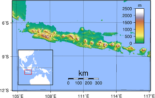
| Description | Topography of Java. Created with GMT from publicly released SRTM data. For locator version, see Image:Java Locator Topography.png |
| Date | |
| Source | Own work |
| Author | Sadalmelik |
Licensing
| I, the copyright holder of this work, release this work into the
public domain. This applies worldwide. In some countries this may not be legally possible; if so: I grant anyone the right to use this work for any purpose, without any conditions, unless such conditions are required by law. |
File history
Click on a date/time to view the file as it appeared at that time.
| Date/Time | Thumbnail | Dimensions | User | Comment | |
|---|---|---|---|---|---|
| current | 18:45, 30 August 2007 |
| 2,688 × 1,693 (1.16 MB) | Sadalmelik | {{Information |Description=Topography of Java. Created with GMT from publicly released SRTM data. |Source=self-made |Date=30 Aug, 2007 |Author= Sadalmelik }} Category:Maps of Indonesia Category:Topographic maps of Asia |
File usage
The following pages on the English Wikipedia use this file (pages on other projects are not listed):
Global file usage
The following other wikis use this file:
- Usage on ace.wikipedia.org
- Usage on af.wikipedia.org
- Usage on az.wikipedia.org
- Usage on ban.wikipedia.org
- Usage on bbc.wikipedia.org
- Usage on bg.wikipedia.org
- Usage on bg.wikibooks.org
- Usage on bjn.wikipedia.org
- Usage on bo.wikipedia.org
- Usage on cs.wikipedia.org
- Usage on de.wikipedia.org
- Usage on el.wikipedia.org
- Usage on en.wiktionary.org
- Usage on eo.wikipedia.org
- Usage on et.wikipedia.org
- Usage on fa.wikipedia.org
- Usage on frr.wikipedia.org
- Usage on fr.wikipedia.org
- Usage on fr.wikinews.org
- Usage on gl.wikipedia.org
- Usage on gor.wikipedia.org
- Usage on hak.wikipedia.org
- Usage on ha.wikipedia.org
- Usage on he.wikipedia.org
- Usage on id.wikipedia.org
- Jawa
- Candi Prambanan
- Bahasa Jawa Banyumasan
- Daftar kabupaten dan kota administrasi di Daerah Khusus Ibukota Jakarta
- Portal:Jawa
- Portal:Jawa/Intro
- Templat:Daftar portal/Indonesia
- Titik ekstrem Jawa
- Bahasa Jawa Indramayu
- Kategori:Sastrawan Jawa
- Garis besar Indonesia
- Kategori:Tokoh ekonomi Jawa
- Kategori:Tokoh seni budaya Jawa
- Kategori:Seniman Jawa
- Bahasa Jawa Pekalongan
- Story:Pulau Jawa
- Daftar kabupaten dan kota administrasi di Daerah Khusus Ibukota Jakarta berdasarkan waktu pembentukan
- Usage on id.wikibooks.org
- Usage on id.wiktionary.org
- Usage on ilo.wikipedia.org
- Usage on incubator.wikimedia.org
- Usage on ka.wikipedia.org
- Usage on km.wikipedia.org
View more global usage of this file.
Size of this preview:
800 × 504 pixels. Other resolutions:
320 × 202 pixels |
640 × 403 pixels |
1,024 × 645 pixels |
1,280 × 806 pixels |
2,688 × 1,693 pixels.
Original file (2,688 × 1,693 pixels, file size: 1.16 MB, MIME type: image/png)
| This is a file from the
Wikimedia Commons. Information from its
description page there is shown below. Commons is a freely licensed media file repository. You can help. |
Summary
| Description | Topography of Java. Created with GMT from publicly released SRTM data. For locator version, see Image:Java Locator Topography.png |
| Date | |
| Source | Own work |
| Author | Sadalmelik |
Licensing
| I, the copyright holder of this work, release this work into the
public domain. This applies worldwide. In some countries this may not be legally possible; if so: I grant anyone the right to use this work for any purpose, without any conditions, unless such conditions are required by law. |
File history
Click on a date/time to view the file as it appeared at that time.
| Date/Time | Thumbnail | Dimensions | User | Comment | |
|---|---|---|---|---|---|
| current | 18:45, 30 August 2007 |
| 2,688 × 1,693 (1.16 MB) | Sadalmelik | {{Information |Description=Topography of Java. Created with GMT from publicly released SRTM data. |Source=self-made |Date=30 Aug, 2007 |Author= Sadalmelik }} Category:Maps of Indonesia Category:Topographic maps of Asia |
File usage
The following pages on the English Wikipedia use this file (pages on other projects are not listed):
Global file usage
The following other wikis use this file:
- Usage on ace.wikipedia.org
- Usage on af.wikipedia.org
- Usage on az.wikipedia.org
- Usage on ban.wikipedia.org
- Usage on bbc.wikipedia.org
- Usage on bg.wikipedia.org
- Usage on bg.wikibooks.org
- Usage on bjn.wikipedia.org
- Usage on bo.wikipedia.org
- Usage on cs.wikipedia.org
- Usage on de.wikipedia.org
- Usage on el.wikipedia.org
- Usage on en.wiktionary.org
- Usage on eo.wikipedia.org
- Usage on et.wikipedia.org
- Usage on fa.wikipedia.org
- Usage on frr.wikipedia.org
- Usage on fr.wikipedia.org
- Usage on fr.wikinews.org
- Usage on gl.wikipedia.org
- Usage on gor.wikipedia.org
- Usage on hak.wikipedia.org
- Usage on ha.wikipedia.org
- Usage on he.wikipedia.org
- Usage on id.wikipedia.org
- Jawa
- Candi Prambanan
- Bahasa Jawa Banyumasan
- Daftar kabupaten dan kota administrasi di Daerah Khusus Ibukota Jakarta
- Portal:Jawa
- Portal:Jawa/Intro
- Templat:Daftar portal/Indonesia
- Titik ekstrem Jawa
- Bahasa Jawa Indramayu
- Kategori:Sastrawan Jawa
- Garis besar Indonesia
- Kategori:Tokoh ekonomi Jawa
- Kategori:Tokoh seni budaya Jawa
- Kategori:Seniman Jawa
- Bahasa Jawa Pekalongan
- Story:Pulau Jawa
- Daftar kabupaten dan kota administrasi di Daerah Khusus Ibukota Jakarta berdasarkan waktu pembentukan
- Usage on id.wikibooks.org
- Usage on id.wiktionary.org
- Usage on ilo.wikipedia.org
- Usage on incubator.wikimedia.org
- Usage on ka.wikipedia.org
- Usage on km.wikipedia.org
View more global usage of this file.