Photos • Location


Size of this PNG preview of this SVG file:
334 × 599 pixels. Other resolutions:
134 × 240 pixels |
267 × 480 pixels |
428 × 768 pixels |
571 × 1,024 pixels |
1,142 × 2,048 pixels |
601 × 1,078 pixels.
Original file (SVG file, nominally 601 × 1,078 pixels, file size: 1.62 MB)
| This is a file from the
Wikimedia Commons. Information from its
description page there is shown below. Commons is a freely licensed media file repository. You can help. |
Summary
| Description |
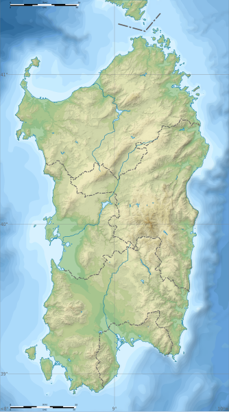
English: Blank physical map of
Sardinia, Italy, for geo-location purpose, with province boundaries. Altitude levels : 25m, 50, 100, 200, 400, 600, etc. (same for bathymetry). Français : Carte topographique vierge de la
Sardaigne, Italie, destinée à la géolocalisation, avec les limites des provinces. Niveaux d'altitudes : 25 m, 50, 100, 200, 400, 600, etc. Idem pour la bathymétrie.
Geographic limits of the map:
|
| Date | (UTC) |
| Source |
Own work
|
| Author | Sémhur |
| Other versions |
Derivative works of this file: Aree protette della Sardegna.svg
|
| Attribution ( required by the license) | © Sémhur / Wikimedia Commons / |
| SVG | W3C-validity not checked. |
| Atelier graphique |

| Camera location | | View this and other nearby images on: OpenStreetMap |
|
|---|
Licensing
I, the copyright holder of this work, hereby publish it under the following licenses:
| Copyleft: This work of art is free; you can redistribute it and/or modify it according to terms of the Free Art License. You will find a specimen of this license on the Copyleft Attitude site as well as on other sites. |
This file is licensed under the
Creative Commons Attribution-Share Alike
Attribution-Share Alike 4.0 International,
3.0 Unported,
2.5 Generic,
2.0 Generic and
1.0 Generic license.
- You are free:
- to share – to copy, distribute and transmit the work
- to remix – to adapt the work
- Under the following conditions:
- attribution – You must give appropriate credit, provide a link to the license, and indicate if changes were made. You may do so in any reasonable manner, but not in any way that suggests the licensor endorses you or your use.
- share alike – If you remix, transform, or build upon the material, you must distribute your contributions under the same or compatible license as the original.
You may select the license of your choice.
File history
Click on a date/time to view the file as it appeared at that time.
| Date/Time | Thumbnail | Dimensions | User | Comment | |
|---|---|---|---|---|---|
| current | 15:26, 4 March 2018 |
| 601 × 1,078 (1.62 MB) | Ruthven | c:User:Rillke/bigChunkedUpload.js: |
| 09:29, 25 February 2018 |
 | 601 × 1,078 (1.62 MB) | Ruthven | New province boundaries (2016) | |
| 15:29, 24 January 2010 |
 | 601 × 1,078 (1.63 MB) | Sémhur | == {{int:filedesc}} == {{Information |Description= {{en|Blank physical map of Sardinia, Italy, for geo-location purpose, with province boundaries. Altitude levels : 25m, 50, 100, 200, 400, 600, etc. (same for bathymetry)}} {{fr|Carte topo |
File usage
The following pages on the English Wikipedia use this file (pages on other projects are not listed):
- 184th Paratroopers Division "Nembo"
- 2019 European Ladies' Team Championship
- 203rd Coastal Division (Italy)
- 204th Coastal Division (Italy)
- 205th Coastal Division (Italy)
- Budelli
- Gulf of Oristano
- Is Molas Challenge
- Is Molas Senior Open
- Lake Baratz
- Lake Coghinas
- Lake Gusana
- Lake Liscia
- Lake Omodeo
- Lake Temo
- Languages of Italy
- Mechanized Brigade "Sassari"
- Punta La Marmora
- Punta Sardegna
- San Pietro Island
- Santo Stefano (island)
- User:Broc/sandbox/Capo Malfatano
- User:Michael!/Project:Location map templates/Italy
- User:Noclador/sandbox/Royal Italian Army - Italy - September 1943
- Template:Sardinia regional languages labelled map
- Module:Location map/data/Italy Sardinia
- Module:Location map/data/Italy Sardinia/doc
- Module:Location map/data/Sardinia
Global file usage
The following other wikis use this file:
- Usage on ar.wikipedia.org
- Usage on az.wikipedia.org
- Usage on ba.wikipedia.org
- Usage on be.wikipedia.org
- Usage on bn.wikipedia.org
- Usage on bs.wikipedia.org
- Usage on ca.wikipedia.org
- Usage on ceb.wikipedia.org
- Usage on ce.wikipedia.org
- Usage on cs.wikipedia.org
- Usage on de.wikipedia.org
- Usage on de.wikivoyage.org
- Usage on dsb.wikipedia.org
- Usage on eo.wikipedia.org
- Usage on es.wikipedia.org
- Caprera
- Archipiélago del Sulcis
- Golfo de Orosei
- Golfo de Oristán
- Golfo de Cagliari
- Nora (Cerdeña)
- Wikiproyecto:Ilustración/Taller de Cartografía/Realizaciones/Europa
- Punta La Marmora
- Cabo Carbonara
- Plantilla:Mapa de localización de Cerdeña
- Gruta de Neptuno
- Área natural marina protegida Cabo Caccia-Isla Piana
- Parque natural regional de Porto Conte
- Faro del Cabo Caccia
- Ponti Mannu
- Faro de Cabo Sándalo
View more global usage of this file.
Metadata
Size of this PNG preview of this SVG file:
334 × 599 pixels. Other resolutions:
134 × 240 pixels |
267 × 480 pixels |
428 × 768 pixels |
571 × 1,024 pixels |
1,142 × 2,048 pixels |
601 × 1,078 pixels.
Original file (SVG file, nominally 601 × 1,078 pixels, file size: 1.62 MB)
| This is a file from the
Wikimedia Commons. Information from its
description page there is shown below. Commons is a freely licensed media file repository. You can help. |
Summary
| Description |
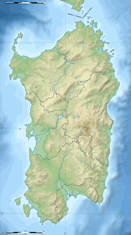
English: Blank physical map of
Sardinia, Italy, for geo-location purpose, with province boundaries. Altitude levels : 25m, 50, 100, 200, 400, 600, etc. (same for bathymetry). Français : Carte topographique vierge de la
Sardaigne, Italie, destinée à la géolocalisation, avec les limites des provinces. Niveaux d'altitudes : 25 m, 50, 100, 200, 400, 600, etc. Idem pour la bathymétrie.
Geographic limits of the map:
|
| Date | (UTC) |
| Source |
Own work
|
| Author | Sémhur |
| Other versions |
Derivative works of this file: Aree protette della Sardegna.svg
|
| Attribution ( required by the license) | © Sémhur / Wikimedia Commons / |
| SVG | W3C-validity not checked. |
| Atelier graphique |
| Camera location | | View this and other nearby images on: OpenStreetMap |
|
|---|
Licensing
I, the copyright holder of this work, hereby publish it under the following licenses:
| Copyleft: This work of art is free; you can redistribute it and/or modify it according to terms of the Free Art License. You will find a specimen of this license on the Copyleft Attitude site as well as on other sites. |
This file is licensed under the
Creative Commons Attribution-Share Alike
Attribution-Share Alike 4.0 International,
3.0 Unported,
2.5 Generic,
2.0 Generic and
1.0 Generic license.
- You are free:
- to share – to copy, distribute and transmit the work
- to remix – to adapt the work
- Under the following conditions:
- attribution – You must give appropriate credit, provide a link to the license, and indicate if changes were made. You may do so in any reasonable manner, but not in any way that suggests the licensor endorses you or your use.
- share alike – If you remix, transform, or build upon the material, you must distribute your contributions under the same or compatible license as the original.
You may select the license of your choice.
File history
Click on a date/time to view the file as it appeared at that time.
| Date/Time | Thumbnail | Dimensions | User | Comment | |
|---|---|---|---|---|---|
| current | 15:26, 4 March 2018 |
| 601 × 1,078 (1.62 MB) | Ruthven | c:User:Rillke/bigChunkedUpload.js: |
| 09:29, 25 February 2018 |
| 601 × 1,078 (1.62 MB) | Ruthven | New province boundaries (2016) | |
| 15:29, 24 January 2010 |
| 601 × 1,078 (1.63 MB) | Sémhur | == {{int:filedesc}} == {{Information |Description= {{en|Blank physical map of Sardinia, Italy, for geo-location purpose, with province boundaries. Altitude levels : 25m, 50, 100, 200, 400, 600, etc. (same for bathymetry)}} {{fr|Carte topo |
File usage
The following pages on the English Wikipedia use this file (pages on other projects are not listed):
- 184th Paratroopers Division "Nembo"
- 2019 European Ladies' Team Championship
- 203rd Coastal Division (Italy)
- 204th Coastal Division (Italy)
- 205th Coastal Division (Italy)
- Budelli
- Gulf of Oristano
- Is Molas Challenge
- Is Molas Senior Open
- Lake Baratz
- Lake Coghinas
- Lake Gusana
- Lake Liscia
- Lake Omodeo
- Lake Temo
- Languages of Italy
- Mechanized Brigade "Sassari"
- Punta La Marmora
- Punta Sardegna
- San Pietro Island
- Santo Stefano (island)
- User:Broc/sandbox/Capo Malfatano
- User:Michael!/Project:Location map templates/Italy
- User:Noclador/sandbox/Royal Italian Army - Italy - September 1943
- Template:Sardinia regional languages labelled map
- Module:Location map/data/Italy Sardinia
- Module:Location map/data/Italy Sardinia/doc
- Module:Location map/data/Sardinia
Global file usage
The following other wikis use this file:
- Usage on ar.wikipedia.org
- Usage on az.wikipedia.org
- Usage on ba.wikipedia.org
- Usage on be.wikipedia.org
- Usage on bn.wikipedia.org
- Usage on bs.wikipedia.org
- Usage on ca.wikipedia.org
- Usage on ceb.wikipedia.org
- Usage on ce.wikipedia.org
- Usage on cs.wikipedia.org
- Usage on de.wikipedia.org
- Usage on de.wikivoyage.org
- Usage on dsb.wikipedia.org
- Usage on eo.wikipedia.org
- Usage on es.wikipedia.org
- Caprera
- Archipiélago del Sulcis
- Golfo de Orosei
- Golfo de Oristán
- Golfo de Cagliari
- Nora (Cerdeña)
- Wikiproyecto:Ilustración/Taller de Cartografía/Realizaciones/Europa
- Punta La Marmora
- Cabo Carbonara
- Plantilla:Mapa de localización de Cerdeña
- Gruta de Neptuno
- Área natural marina protegida Cabo Caccia-Isla Piana
- Parque natural regional de Porto Conte
- Faro del Cabo Caccia
- Ponti Mannu
- Faro de Cabo Sándalo
View more global usage of this file.