Photos • Location


Size of this PNG preview of this SVG file:
533 × 600 pixels. Other resolutions:
213 × 240 pixels |
427 × 480 pixels |
683 × 768 pixels |
910 × 1,024 pixels |
1,820 × 2,048 pixels |
903 × 1,016 pixels.
Original file (SVG file, nominally 903 × 1,016 pixels, file size: 1.48 MB)
| This is a file from the
Wikimedia Commons. Information from its
description page there is shown below. Commons is a freely licensed media file repository. You can help. |
Summary
| Camera location |
| View this and other nearby images on: OpenStreetMap |
|
|---|
| Description | |
| Date |
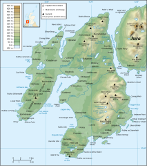
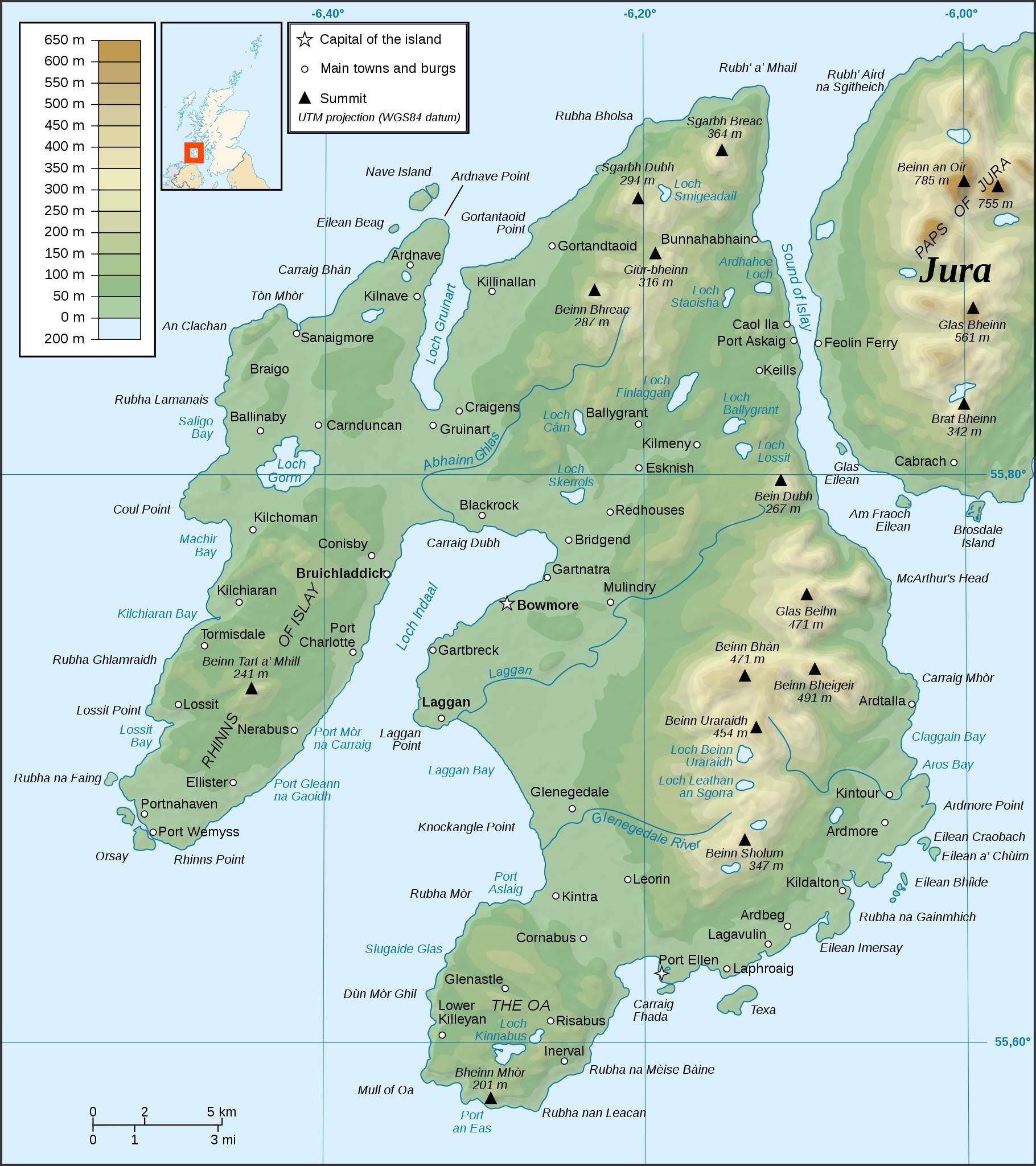
English: February 2008 Français : Février 2008 |
| Source |
English: Own work ; Topography : NASA Shuttle Radar Topography Mission (SRTM3 v.2) data (public domain) edited with 3DEM and dlgv32 Pro and vectorized with Inkscape ; UTM projection ; WGS84 datum ; shaded relief (composite image of N-W, W and N lightning positions) ; Bathymetry : USGov public domain data provided by Demis (see the approval e-mail and the Demis forum) ; Reference used for the additional data : Magic ; Locator map : Sting's composition of Image:British_Isles_Northern_Ireland.svg, Image:British_Isles_Scotland.svg and Image:British_Isles_Wales.svg (modified) created by Cnbrb under PD ; Note: The shaded relief is a raster image embedded in the SVG file. Français : Création personnelle grâce aux
didacticiels de Sting; Topographie : Données de la NASA Shuttle Radar Topography Mission (SRTM3 v.2) (domaine public) éditées avec 3DEM et dlgv32 Pro et vectorisées avec Inkscape ; projection UTM ; WGS84 datum ; relief ombré (image composite d'éclairages du N-O, O et N) ; Bathymétrie : Données du gouvernement des ÉUA dans le domaine public fournies par Demis (voir le courriel d'approbation et le forum de Demis) ; Référence utilisée pour les données complémentaires : Magic ; Carte de localisation : version adaptée de la composition de Sting de Image:British_Isles_Northern_Ireland.svg, Image:British_Isles_Scotland.svg et Image:British_Isles_Wales.svg (modifiées) créées par Cnbrb ; |
| Author | Ayack |
| Other versions |
|


|
This SVG file contains embedded text that can be translated into your language, using any capable SVG editor, text editor or the SVG Translate tool. For more information see: About translating SVG files. |
Licensing
I, the copyright holder of this work, hereby publish it under the following licenses:

|
Permission is granted to copy, distribute and/or modify this document under the terms of the GNU Free Documentation License, Version 1.2 or any later version published by the Free Software Foundation; with no Invariant Sections, no Front-Cover Texts, and no Back-Cover Texts. A copy of the license is included in the section entitled GNU Free Documentation License. |
This file is licensed under the
Creative Commons
Attribution-Share Alike 3.0 Unported license.
- You are free:
- to share – to copy, distribute and transmit the work
- to remix – to adapt the work
- Under the following conditions:
- attribution – You must give appropriate credit, provide a link to the license, and indicate if changes were made. You may do so in any reasonable manner, but not in any way that suggests the licensor endorses you or your use.
- share alike – If you remix, transform, or build upon the material, you must distribute your contributions under the same or compatible license as the original.
You may select the license of your choice.
File history
Click on a date/time to view the file as it appeared at that time.
| Date/Time | Thumbnail | Dimensions | User | Comment | |
|---|---|---|---|---|---|
| current | 19:52, 20 November 2008 |
| 903 × 1,016 (1.48 MB) | Ayack | Corrections : Salige Bay → Saligo Bay, Beinn Bheigier → Beinn Bheigeir, Kildaton → Kildalton |
| 22:57, 12 February 2008 |
 | 903 × 1,016 (1.48 MB) | Ayack | Retrait image oubliée | |
| 22:46, 12 February 2008 |
 | 903 × 1,016 (5 MB) | Ayack | == Description == {{Location|55|45|41.8|N|6|15|43.9|W|scale:200000}} {{Information |Description={{en|Topographic map in French of Islay, Scotland.}}{{fr|Carte topographique de l'île d' Islay en [[:fr |
File usage
The following pages on the English Wikipedia use this file (pages on other projects are not listed):
Global file usage
The following other wikis use this file:
- Usage on br.wikipedia.org
- Usage on de.wikipedia.org
- Usage on el.wikipedia.org
- Usage on es.wikipedia.org
- Usage on gl.wikipedia.org
- Usage on he.wikipedia.org
- Usage on ko.wikipedia.org
- Usage on nl.wikipedia.org
- Usage on nn.wikipedia.org
- Usage on no.wikipedia.org
- Usage on pl.wikipedia.org
- Usage on sv.wikipedia.org
- Usage on th.wikipedia.org
- Usage on tr.wikipedia.org
Size of this PNG preview of this SVG file:
533 × 600 pixels. Other resolutions:
213 × 240 pixels |
427 × 480 pixels |
683 × 768 pixels |
910 × 1,024 pixels |
1,820 × 2,048 pixels |
903 × 1,016 pixels.
Original file (SVG file, nominally 903 × 1,016 pixels, file size: 1.48 MB)
| This is a file from the
Wikimedia Commons. Information from its
description page there is shown below. Commons is a freely licensed media file repository. You can help. |
Summary
| Camera location |
| View this and other nearby images on: OpenStreetMap |
|
|---|
| Description | |
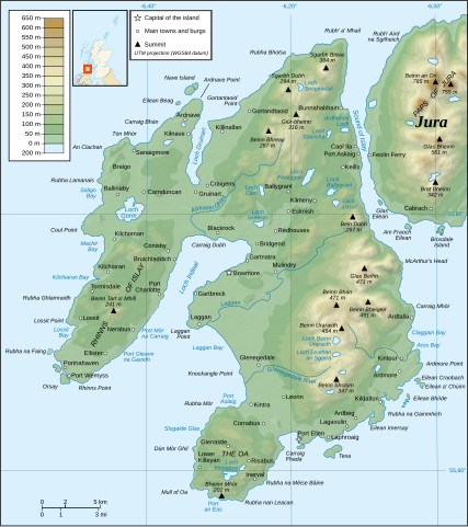
| Date |
English: February 2008 Français : Février 2008 |
| Source |
English: Own work ; Topography : NASA Shuttle Radar Topography Mission (SRTM3 v.2) data (public domain) edited with 3DEM and dlgv32 Pro and vectorized with Inkscape ; UTM projection ; WGS84 datum ; shaded relief (composite image of N-W, W and N lightning positions) ; Bathymetry : USGov public domain data provided by Demis (see the approval e-mail and the Demis forum) ; Reference used for the additional data : Magic ; Locator map : Sting's composition of Image:British_Isles_Northern_Ireland.svg, Image:British_Isles_Scotland.svg and Image:British_Isles_Wales.svg (modified) created by Cnbrb under PD ; Note: The shaded relief is a raster image embedded in the SVG file. Français : Création personnelle grâce aux
didacticiels de Sting; Topographie : Données de la NASA Shuttle Radar Topography Mission (SRTM3 v.2) (domaine public) éditées avec 3DEM et dlgv32 Pro et vectorisées avec Inkscape ; projection UTM ; WGS84 datum ; relief ombré (image composite d'éclairages du N-O, O et N) ; Bathymétrie : Données du gouvernement des ÉUA dans le domaine public fournies par Demis (voir le courriel d'approbation et le forum de Demis) ; Référence utilisée pour les données complémentaires : Magic ; Carte de localisation : version adaptée de la composition de Sting de Image:British_Isles_Northern_Ireland.svg, Image:British_Isles_Scotland.svg et Image:British_Isles_Wales.svg (modifiées) créées par Cnbrb ; |
| Author | Ayack |
| Other versions |
|
|
|
This SVG file contains embedded text that can be translated into your language, using any capable SVG editor, text editor or the SVG Translate tool. For more information see: About translating SVG files. |
Licensing
I, the copyright holder of this work, hereby publish it under the following licenses:
|
|
Permission is granted to copy, distribute and/or modify this document under the terms of the GNU Free Documentation License, Version 1.2 or any later version published by the Free Software Foundation; with no Invariant Sections, no Front-Cover Texts, and no Back-Cover Texts. A copy of the license is included in the section entitled GNU Free Documentation License. |
This file is licensed under the
Creative Commons
Attribution-Share Alike 3.0 Unported license.
- You are free:
- to share – to copy, distribute and transmit the work
- to remix – to adapt the work
- Under the following conditions:
- attribution – You must give appropriate credit, provide a link to the license, and indicate if changes were made. You may do so in any reasonable manner, but not in any way that suggests the licensor endorses you or your use.
- share alike – If you remix, transform, or build upon the material, you must distribute your contributions under the same or compatible license as the original.
You may select the license of your choice.
File history
Click on a date/time to view the file as it appeared at that time.
| Date/Time | Thumbnail | Dimensions | User | Comment | |
|---|---|---|---|---|---|
| current | 19:52, 20 November 2008 |
| 903 × 1,016 (1.48 MB) | Ayack | Corrections : Salige Bay → Saligo Bay, Beinn Bheigier → Beinn Bheigeir, Kildaton → Kildalton |
| 22:57, 12 February 2008 |
| 903 × 1,016 (1.48 MB) | Ayack | Retrait image oubliée | |
| 22:46, 12 February 2008 |
| 903 × 1,016 (5 MB) | Ayack | == Description == {{Location|55|45|41.8|N|6|15|43.9|W|scale:200000}} {{Information |Description={{en|Topographic map in French of Islay, Scotland.}}{{fr|Carte topographique de l'île d' Islay en [[:fr |
File usage
The following pages on the English Wikipedia use this file (pages on other projects are not listed):
Global file usage
The following other wikis use this file:
- Usage on br.wikipedia.org
- Usage on de.wikipedia.org
- Usage on el.wikipedia.org
- Usage on es.wikipedia.org
- Usage on gl.wikipedia.org
- Usage on he.wikipedia.org
- Usage on ko.wikipedia.org
- Usage on nl.wikipedia.org
- Usage on nn.wikipedia.org
- Usage on no.wikipedia.org
- Usage on pl.wikipedia.org
- Usage on sv.wikipedia.org
- Usage on th.wikipedia.org
- Usage on tr.wikipedia.org