
Size of this PNG preview of this SVG file:
429 × 599 pixels. Other resolutions:
172 × 240 pixels |
344 × 480 pixels |
550 × 768 pixels |
733 × 1,024 pixels |
1,467 × 2,048 pixels |
851 × 1,188 pixels.
Original file (SVG file, nominally 851 × 1,188 pixels, file size: 1.86 MB)
| This is a file from the
Wikimedia Commons. Information from its
description page there is shown below. Commons is a freely licensed media file repository. You can help. |

Summary
| Description |
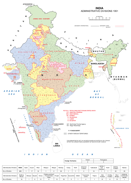
English: India Administrative Divisions in 1951. |
| Date | |
| Source | Own work |
| Author | Andhrapur |
| This file is made available under the Creative Commons CC0 1.0 Universal Public Domain Dedication. | |
| The person who associated a work with this deed has dedicated the work to the
public domain by waiving all of their rights to the work worldwide under copyright law, including all related and neighboring rights, to the extent allowed by law. You can copy, modify, distribute and perform the work, even for commercial purposes, all without asking permission.
|
File history
Click on a date/time to view the file as it appeared at that time.
| Date/Time | Thumbnail | Dimensions | User | Comment | |
|---|---|---|---|---|---|
| current | 13:34, 9 August 2012 |
| 851 × 1,188 (1.86 MB) | Andhrapur | Made some corrections. |
| 13:28, 9 August 2012 |
 | 765 × 990 (1.86 MB) | Andhrapur | Smaller size. | |
| 12:51, 9 August 2012 |
 | 905 × 1,254 (2.45 MB) | Andhrapur | {{subst:Upload marker added by en.wp UW}} {{Information |Description = {{en|India Administrative Divisions in 1951.}} |Source = {{own}} |Date = 2012-08-09 |Author = Andhrapur }} {{cc-zero}} |
File usage
The following pages on the English Wikipedia use this file (pages on other projects are not listed):
- 1952 Ajmer State Legislative Assembly election
- 1952 Assam Legislative Assembly election
- 1952 Bhopal State Legislative Assembly election
- 1952 Bombay State Legislative Assembly election
- 1952 Coorg State Legislative Assembly election
- 1952 Delhi Legislative Assembly election
- 1952 Hyderabad State Legislative Assembly election
- 1952 Madhya Bharat Legislative Assembly election
- 1952 Madhya Pradesh Legislative Assembly election
- 1952 Madras State Legislative Assembly election
- 1952 Mysore State Legislative Assembly election
- 1952 Odisha Legislative Assembly election
- 1952 Patiala and East Punjab States Union Legislative Assembly election
- 1952 Punjab Legislative Assembly election
- 1952 Rajasthan Legislative Assembly election
- 1952 Saurashtra Legislative Assembly election
- 1952 Travancore-Cochin Legislative Assembly election
- 1952 Uttar Pradesh Legislative Assembly election
- 1952 Vindhya Pradesh Legislative Assembly election
- 1952 West Bengal Legislative Assembly election
- 1954 Travancore-Cochin Legislative Assembly election
- 1967 Assam Legislative Assembly election
- East Punjab
- History of Bellary
- List of members of the 1st Lok Sabha
- Mahagujarat movement
- States Reorganisation Act, 1956
- States Reorganisation Commission
- Union territory
- Wikipedia:Reference desk/Archives/Humanities/2018 July 27
Global file usage
The following other wikis use this file:
- Usage on ar.wikipedia.org
- Usage on ast.wikipedia.org
- Usage on be-tarask.wikipedia.org
- Usage on bn.wikipedia.org
- Usage on ce.wikipedia.org
- Usage on cs.wikipedia.org
- Usage on el.wikipedia.org
- Usage on en.wikibooks.org
- Usage on es.wikipedia.org
- Usage on eu.wikipedia.org
- Usage on fr.wikipedia.org
- Usage on gu.wikipedia.org
- Usage on he.wikipedia.org
- Usage on hi.wikipedia.org
- Usage on id.wikipedia.org
- Usage on kn.wikipedia.org
- Usage on lv.wikipedia.org
- Usage on ml.wikipedia.org
- Usage on mr.wikipedia.org
- Usage on nl.wikipedia.org
- Usage on nn.wikipedia.org
- Usage on no.wikipedia.org
- Usage on or.wikipedia.org
- Usage on pa.wikipedia.org
View more global usage of this file.
Size of this PNG preview of this SVG file:
429 × 599 pixels. Other resolutions:
172 × 240 pixels |
344 × 480 pixels |
550 × 768 pixels |
733 × 1,024 pixels |
1,467 × 2,048 pixels |
851 × 1,188 pixels.
Original file (SVG file, nominally 851 × 1,188 pixels, file size: 1.86 MB)
| This is a file from the
Wikimedia Commons. Information from its
description page there is shown below. Commons is a freely licensed media file repository. You can help. |
Summary
| Description |
English: India Administrative Divisions in 1951. |
| Date | |
| Source | Own work |
| Author | Andhrapur |
| This file is made available under the Creative Commons CC0 1.0 Universal Public Domain Dedication. | |
| The person who associated a work with this deed has dedicated the work to the
public domain by waiving all of their rights to the work worldwide under copyright law, including all related and neighboring rights, to the extent allowed by law. You can copy, modify, distribute and perform the work, even for commercial purposes, all without asking permission.
|
File history
Click on a date/time to view the file as it appeared at that time.
| Date/Time | Thumbnail | Dimensions | User | Comment | |
|---|---|---|---|---|---|
| current | 13:34, 9 August 2012 |
| 851 × 1,188 (1.86 MB) | Andhrapur | Made some corrections. |
| 13:28, 9 August 2012 |
| 765 × 990 (1.86 MB) | Andhrapur | Smaller size. | |
| 12:51, 9 August 2012 |
| 905 × 1,254 (2.45 MB) | Andhrapur | {{subst:Upload marker added by en.wp UW}} {{Information |Description = {{en|India Administrative Divisions in 1951.}} |Source = {{own}} |Date = 2012-08-09 |Author = Andhrapur }} {{cc-zero}} |
File usage
The following pages on the English Wikipedia use this file (pages on other projects are not listed):
- 1952 Ajmer State Legislative Assembly election
- 1952 Assam Legislative Assembly election
- 1952 Bhopal State Legislative Assembly election
- 1952 Bombay State Legislative Assembly election
- 1952 Coorg State Legislative Assembly election
- 1952 Delhi Legislative Assembly election
- 1952 Hyderabad State Legislative Assembly election
- 1952 Madhya Bharat Legislative Assembly election
- 1952 Madhya Pradesh Legislative Assembly election
- 1952 Madras State Legislative Assembly election
- 1952 Mysore State Legislative Assembly election
- 1952 Odisha Legislative Assembly election
- 1952 Patiala and East Punjab States Union Legislative Assembly election
- 1952 Punjab Legislative Assembly election
- 1952 Rajasthan Legislative Assembly election
- 1952 Saurashtra Legislative Assembly election
- 1952 Travancore-Cochin Legislative Assembly election
- 1952 Uttar Pradesh Legislative Assembly election
- 1952 Vindhya Pradesh Legislative Assembly election
- 1952 West Bengal Legislative Assembly election
- 1954 Travancore-Cochin Legislative Assembly election
- 1967 Assam Legislative Assembly election
- East Punjab
- History of Bellary
- List of members of the 1st Lok Sabha
- Mahagujarat movement
- States Reorganisation Act, 1956
- States Reorganisation Commission
- Union territory
- Wikipedia:Reference desk/Archives/Humanities/2018 July 27
Global file usage
The following other wikis use this file:
- Usage on ar.wikipedia.org
- Usage on ast.wikipedia.org
- Usage on be-tarask.wikipedia.org
- Usage on bn.wikipedia.org
- Usage on ce.wikipedia.org
- Usage on cs.wikipedia.org
- Usage on el.wikipedia.org
- Usage on en.wikibooks.org
- Usage on es.wikipedia.org
- Usage on eu.wikipedia.org
- Usage on fr.wikipedia.org
- Usage on gu.wikipedia.org
- Usage on he.wikipedia.org
- Usage on hi.wikipedia.org
- Usage on id.wikipedia.org
- Usage on kn.wikipedia.org
- Usage on lv.wikipedia.org
- Usage on ml.wikipedia.org
- Usage on mr.wikipedia.org
- Usage on nl.wikipedia.org
- Usage on nn.wikipedia.org
- Usage on no.wikipedia.org
- Usage on or.wikipedia.org
- Usage on pa.wikipedia.org
View more global usage of this file.