Photos • Location


Size of this preview:
800 × 548 pixels. Other resolutions:
320 × 219 pixels |
640 × 439 pixels |
1,024 × 702 pixels |
1,280 × 877 pixels |
2,911 × 1,995 pixels.
Original file (2,911 × 1,995 pixels, file size: 605 KB, MIME type: image/jpeg)
| This is a file from the
Wikimedia Commons. Information from its
description page there is shown below. Commons is a freely licensed media file repository. You can help. |
Summary
| Description |
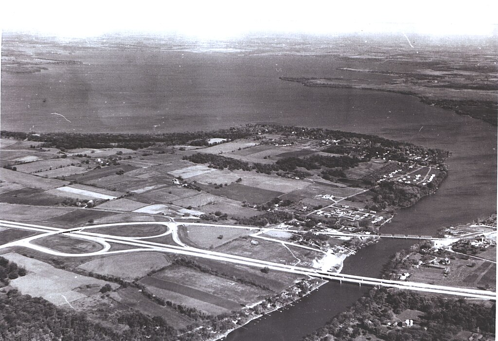
English: Interstate Route 90 crosses the Rock River on twin bridges and intersects State Route 59 near Edgerton on its way from Chicago to Wisconsin Dells. |
| Date | |
| Source | https://highways.dot.gov/highway-history/general-highway-history/gallery/interstate-photo-gallery-all-high-resolution-images |
| Author | Federal Highway Adminstration |
| Object location |
| View this and other nearby images on: OpenStreetMap |
|
|---|
Licensing
| This image is a work of a
United States Department of Transportation employee, taken or made as part of that person's official duties. As a
work of the
U.S. federal government, the image is in the
public domain.
|
|
File history
Click on a date/time to view the file as it appeared at that time.
| Date/Time | Thumbnail | Dimensions | User | Comment | |
|---|---|---|---|---|---|
| current | 01:46, 22 July 2024 |
| 2,911 × 1,995 (605 KB) | TheImaCow | Uploaded a work by Federal Highway Adminstration from https://highways.dot.gov/highway-history/general-highway-history/gallery/interstate-photo-gallery-all-high-resolution-images with UploadWizard |
File usage
The following pages on the English Wikipedia use this file (pages on other projects are not listed):
Metadata
Size of this preview:
800 × 548 pixels. Other resolutions:
320 × 219 pixels |
640 × 439 pixels |
1,024 × 702 pixels |
1,280 × 877 pixels |
2,911 × 1,995 pixels.
Original file (2,911 × 1,995 pixels, file size: 605 KB, MIME type: image/jpeg)
| This is a file from the
Wikimedia Commons. Information from its
description page there is shown below. Commons is a freely licensed media file repository. You can help. |
Summary
| Description |
English: Interstate Route 90 crosses the Rock River on twin bridges and intersects State Route 59 near Edgerton on its way from Chicago to Wisconsin Dells. |
| Date | |
| Source | https://highways.dot.gov/highway-history/general-highway-history/gallery/interstate-photo-gallery-all-high-resolution-images |
| Author | Federal Highway Adminstration |
| Object location |
| View this and other nearby images on: OpenStreetMap |
|
|---|
Licensing
| This image is a work of a
United States Department of Transportation employee, taken or made as part of that person's official duties. As a
work of the
U.S. federal government, the image is in the
public domain.
|
|
File history
Click on a date/time to view the file as it appeared at that time.
| Date/Time | Thumbnail | Dimensions | User | Comment | |
|---|---|---|---|---|---|
| current | 01:46, 22 July 2024 |
| 2,911 × 1,995 (605 KB) | TheImaCow | Uploaded a work by Federal Highway Adminstration from https://highways.dot.gov/highway-history/general-highway-history/gallery/interstate-photo-gallery-all-high-resolution-images with UploadWizard |
File usage
The following pages on the English Wikipedia use this file (pages on other projects are not listed):