Original file (1,070 × 1,423 pixels, file size: 135 KB, MIME type: image/png)
| This is a file from the
Wikimedia Commons. Information from its
description page there is shown below. Commons is a freely licensed media file repository. You can help. |
Summary
| Description |
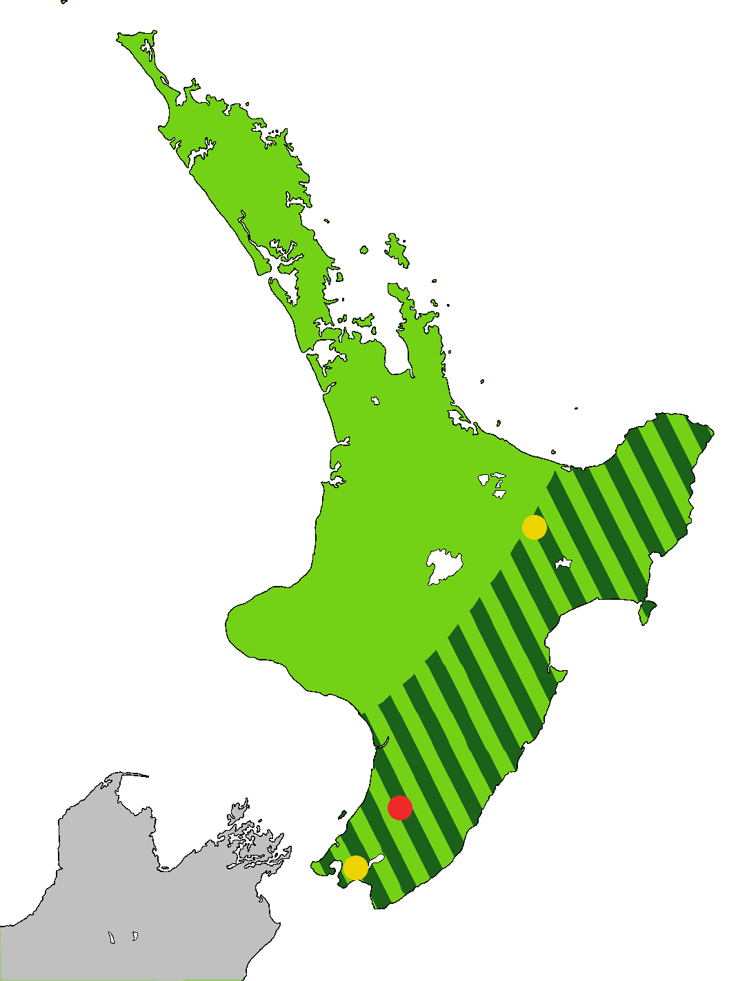
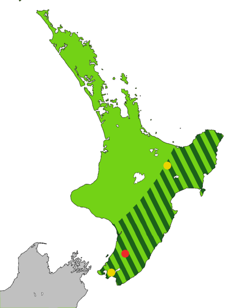
English: Light green: Range of the Huia, Heteralocha acutirostris, before the arrival of humans to New Zealand, as indicated by fossils. Dark green stripes: Range at 1840. Last sightings of the Huia: Red - last confirmed sighting in 1907 in Tararua Range. Yellow x 2 include one behind Eastbourne at the southern end of the North Island, and one in the Te Urewera National Park. The Huia is an extinct bird that was endemic to the North Island of New Zealand
Čeština: Laločník ostrozobý – distribuce. Světle zeleně: původní rozšíření laločníka ostrozobého; tmavě zelenými pruhy: rozsah druhu kolem roku 1840; červený bod: poslední potvrzené pozorování; žlutý bod: neověřená pozorování |
| Date | |
| Source | Own work. Based on first version by Casliber with information provided by User:Kotare, using as a base for the outline File:New Zealand location map transparent.svg adapted by uploader User:Kahuroa |
| Author | Kahuroa |
Licensing
| This work has been released into the
public domain by its author,
Kahuroa. This applies worldwide. In some countries this may not be legally possible; if so: |
File history
Click on a date/time to view the file as it appeared at that time.
| Date/Time | Thumbnail | Dimensions | User | Comment | |
|---|---|---|---|---|---|
| current | 18:36, 14 September 2010 |
| 1,070 × 1,423 (135 KB) | Kahuroa | Use new outline source: File:New Zealand location map transparent.svg adapted by uploader User:Kahuroa |
| 07:31, 31 August 2010 |
 | 1,760 × 2,346 (220 KB) | Kahuroa | New map - uses stripes to denote range in 1840 | |
| 21:46, 21 July 2010 |
 | 449 × 599 (49 KB) | Casliber | {{Information |Description= |Source={{own}} |Date= |Author= Casliber |Permission= |other_versions= }} | |
| 21:04, 21 July 2010 |
 | 449 × 599 (49 KB) | Casliber | {{Information |Description= Map added last sitings of the Huia. Red - last confirmed siting in 1907 in Tararua Range. Yellow x 2 include one behind Eastbourne, and one in the Te Urewera National Park. |Source={{own}} |Date= 23rd July 2010 |Author= [[User: | |
| 20:52, 21 July 2010 |
 | 449 × 599 (48 KB) | Casliber | {{Information |Description={{en|1=Map of deforestation of North Island on New Zealand}} |Source={{own}} |Author= Casliber |Date=22nd July 2010 |Permission=yes |other_versions=no }} Category:Maps |
File usage
Global file usage
The following other wikis use this file:
- Usage on ar.wikipedia.org
- Usage on bn.wikipedia.org
- Usage on ca.wikipedia.org
- Usage on ceb.wikipedia.org
- Usage on cs.wikipedia.org
- Usage on es.wikipedia.org
- Usage on eu.wikipedia.org
- Usage on fa.wikipedia.org
- Usage on gl.wikipedia.org
- Usage on he.wikipedia.org
- Usage on hu.wikipedia.org
- Usage on id.wikipedia.org
- Usage on it.wikipedia.org
- Usage on nn.wikipedia.org
- Usage on pl.wikipedia.org
- Usage on pt.wikipedia.org
- Usage on ru.wikipedia.org
- Usage on sr.wikipedia.org
- Usage on sv.wikipedia.org
- Usage on ta.wikipedia.org
- Usage on uk.wikipedia.org
- Usage on vi.wikipedia.org
- Usage on www.wikidata.org
- Usage on zh.wikipedia.org
Metadata
Original file (1,070 × 1,423 pixels, file size: 135 KB, MIME type: image/png)
| This is a file from the
Wikimedia Commons. Information from its
description page there is shown below. Commons is a freely licensed media file repository. You can help. |
Summary
| Description |
English: Light green: Range of the Huia, Heteralocha acutirostris, before the arrival of humans to New Zealand, as indicated by fossils. Dark green stripes: Range at 1840. Last sightings of the Huia: Red - last confirmed sighting in 1907 in Tararua Range. Yellow x 2 include one behind Eastbourne at the southern end of the North Island, and one in the Te Urewera National Park. The Huia is an extinct bird that was endemic to the North Island of New Zealand
Čeština: Laločník ostrozobý – distribuce. Světle zeleně: původní rozšíření laločníka ostrozobého; tmavě zelenými pruhy: rozsah druhu kolem roku 1840; červený bod: poslední potvrzené pozorování; žlutý bod: neověřená pozorování |
| Date | |
| Source | Own work. Based on first version by Casliber with information provided by User:Kotare, using as a base for the outline File:New Zealand location map transparent.svg adapted by uploader User:Kahuroa |
| Author | Kahuroa |
Licensing
| This work has been released into the
public domain by its author,
Kahuroa. This applies worldwide. In some countries this may not be legally possible; if so: |
File history
Click on a date/time to view the file as it appeared at that time.
| Date/Time | Thumbnail | Dimensions | User | Comment | |
|---|---|---|---|---|---|
| current | 18:36, 14 September 2010 |
| 1,070 × 1,423 (135 KB) | Kahuroa | Use new outline source: File:New Zealand location map transparent.svg adapted by uploader User:Kahuroa |
| 07:31, 31 August 2010 |
| 1,760 × 2,346 (220 KB) | Kahuroa | New map - uses stripes to denote range in 1840 | |
| 21:46, 21 July 2010 |
| 449 × 599 (49 KB) | Casliber | {{Information |Description= |Source={{own}} |Date= |Author= Casliber |Permission= |other_versions= }} | |
| 21:04, 21 July 2010 |
| 449 × 599 (49 KB) | Casliber | {{Information |Description= Map added last sitings of the Huia. Red - last confirmed siting in 1907 in Tararua Range. Yellow x 2 include one behind Eastbourne, and one in the Te Urewera National Park. |Source={{own}} |Date= 23rd July 2010 |Author= [[User: | |
| 20:52, 21 July 2010 |
| 449 × 599 (48 KB) | Casliber | {{Information |Description={{en|1=Map of deforestation of North Island on New Zealand}} |Source={{own}} |Author= Casliber |Date=22nd July 2010 |Permission=yes |other_versions=no }} Category:Maps |
File usage
Global file usage
The following other wikis use this file:
- Usage on ar.wikipedia.org
- Usage on bn.wikipedia.org
- Usage on ca.wikipedia.org
- Usage on ceb.wikipedia.org
- Usage on cs.wikipedia.org
- Usage on es.wikipedia.org
- Usage on eu.wikipedia.org
- Usage on fa.wikipedia.org
- Usage on gl.wikipedia.org
- Usage on he.wikipedia.org
- Usage on hu.wikipedia.org
- Usage on id.wikipedia.org
- Usage on it.wikipedia.org
- Usage on nn.wikipedia.org
- Usage on pl.wikipedia.org
- Usage on pt.wikipedia.org
- Usage on ru.wikipedia.org
- Usage on sr.wikipedia.org
- Usage on sv.wikipedia.org
- Usage on ta.wikipedia.org
- Usage on uk.wikipedia.org
- Usage on vi.wikipedia.org
- Usage on www.wikidata.org
- Usage on zh.wikipedia.org