Photos • Location


No higher resolution available.
Hatherwood_Point_and_Alum_Bay_-_geograph.org.uk_-_1377275.jpg (640 × 428 pixels, file size: 191 KB, MIME type: image/jpeg)
| This is a file from the
Wikimedia Commons. Information from its
description page there is shown below. Commons is a freely licensed media file repository. You can help. |
Summary
| Description |
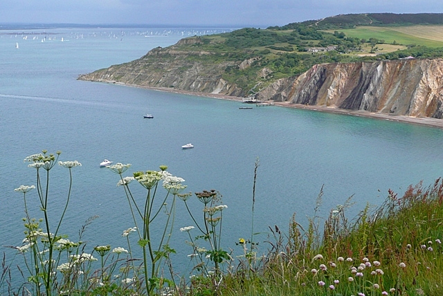
English: Hatherwood Point and Alum Bay Taken from the road to the Old Battery. Alum Bay sweeps round and across the vertically aligned strata of the Tertiary rocks. Beyond is an area of landslips at Headon Warren, ending at Hatherwood Point. The bulk of the competitors in the 2009 Round the Island yacht race are making their way down the Solent through the narrow gap created by Hurst Castle spit. |
| Date | |
| Source | From geograph.org.uk |
| Author | Graham Horn |
| Attribution ( required by the license) | Graham Horn / Hatherwood Point and Alum Bay / |
| Camera location | | View this and other nearby images on: OpenStreetMap |
|
|---|
_heading:22.00&language=en)
| Object location | | View this and other nearby images on: OpenStreetMap |
|
|---|
_heading:22.00&language=en)
Licensing

|
This image was taken from the
Geograph project collection. See
this photograph's page on the Geograph website for the photographer's contact details. The copyright on this image is owned by Graham Horn and is licensed for reuse under the
Creative Commons Attribution-ShareAlike 2.0 license.
|
This file is licensed under the
Creative Commons
Attribution-Share Alike 2.0 Generic license.
Attribution: Graham Horn
- You are free:
- to share – to copy, distribute and transmit the work
- to remix – to adapt the work
- Under the following conditions:
- attribution – You must give appropriate credit, provide a link to the license, and indicate if changes were made. You may do so in any reasonable manner, but not in any way that suggests the licensor endorses you or your use.
- share alike – If you remix, transform, or build upon the material, you must distribute your contributions under the same or compatible license as the original.
File history
Click on a date/time to view the file as it appeared at that time.
| Date/Time | Thumbnail | Dimensions | User | Comment | |
|---|---|---|---|---|---|
| current | 14:58, 28 February 2011 |
| 640 × 428 (191 KB) | GeographBot | == {{int:filedesc}} == {{Information |description={{en|1=Hatherwood Point and Alum Bay Taken from the road to the Old Battery. Alum Bay sweeps round and across the vertically aligned strata of the Tertiary rocks. Beyond is an area of landslips at Headon |
File usage
The following pages on the English Wikipedia use this file (pages on other projects are not listed):
Global file usage
The following other wikis use this file:
- Usage on www.wikidata.org
Metadata
No higher resolution available.
Hatherwood_Point_and_Alum_Bay_-_geograph.org.uk_-_1377275.jpg (640 × 428 pixels, file size: 191 KB, MIME type: image/jpeg)
| This is a file from the
Wikimedia Commons. Information from its
description page there is shown below. Commons is a freely licensed media file repository. You can help. |
Summary
| Description |
English: Hatherwood Point and Alum Bay Taken from the road to the Old Battery. Alum Bay sweeps round and across the vertically aligned strata of the Tertiary rocks. Beyond is an area of landslips at Headon Warren, ending at Hatherwood Point. The bulk of the competitors in the 2009 Round the Island yacht race are making their way down the Solent through the narrow gap created by Hurst Castle spit. |
| Date | |
| Source | From geograph.org.uk |
| Author | Graham Horn |
| Attribution ( required by the license) | Graham Horn / Hatherwood Point and Alum Bay / |
| Camera location | | View this and other nearby images on: OpenStreetMap |
|
|---|
| Object location | | View this and other nearby images on: OpenStreetMap |
|
|---|
Licensing
|
|
This image was taken from the
Geograph project collection. See
this photograph's page on the Geograph website for the photographer's contact details. The copyright on this image is owned by Graham Horn and is licensed for reuse under the
Creative Commons Attribution-ShareAlike 2.0 license.
|
This file is licensed under the
Creative Commons
Attribution-Share Alike 2.0 Generic license.
Attribution: Graham Horn
- You are free:
- to share – to copy, distribute and transmit the work
- to remix – to adapt the work
- Under the following conditions:
- attribution – You must give appropriate credit, provide a link to the license, and indicate if changes were made. You may do so in any reasonable manner, but not in any way that suggests the licensor endorses you or your use.
- share alike – If you remix, transform, or build upon the material, you must distribute your contributions under the same or compatible license as the original.
File history
Click on a date/time to view the file as it appeared at that time.
| Date/Time | Thumbnail | Dimensions | User | Comment | |
|---|---|---|---|---|---|
| current | 14:58, 28 February 2011 |
| 640 × 428 (191 KB) | GeographBot | == {{int:filedesc}} == {{Information |description={{en|1=Hatherwood Point and Alum Bay Taken from the road to the Old Battery. Alum Bay sweeps round and across the vertically aligned strata of the Tertiary rocks. Beyond is an area of landslips at Headon |
File usage
The following pages on the English Wikipedia use this file (pages on other projects are not listed):
Global file usage
The following other wikis use this file:
- Usage on www.wikidata.org