
Original file (1,155 × 522 pixels, file size: 97 KB, MIME type: image/jpeg)
| This is a file from the
Wikimedia Commons. Information from its
description page there is shown below. Commons is a freely licensed media file repository. You can help. |
Summary
| Description |
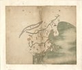
English: Eastern Inner Mongolia from the General Map of the 1754 Da Qing Fensheng Yutu, showing Harqin between the Great Wall, the Mongols, and the Desert. Pen-and-ink and watercolor. Library of Congress copy, G2305 .D35 1782 Vault Shelf, G2305 .T15 17-- Vault |
||
| Title | English: Provincial Atlas of the Qing Empire
中文:大清分省輿圖 |
||
| Shelf ID | G2305 .D35 1760 | ||
| Parent | https://www.loc.gov/resource/g7820m.gct00229/ | ||
| Sheet title | English: Untitled general map
中文:无 |
||
| Date | |||
| Source | LOC | ||
| Author | Unknown author | ||
| Permission ( Reusing this file) |
|
||
| Other versions |
|
||
| Location | Inner Mongolia · China | ||
| Part of | American Memory · General Maps · Catalog · Geography And Map Division | ||
| Subject | Atlases · Early Maps · Maps · Early Works To 1800 · China · Administrative And Political Divisions · Manuscript Maps |


Licensing
|
This is a faithful photographic reproduction of a two-dimensional,
public domain work of art. The work of art itself is in the public domain for the following reason:
The official position taken by the Wikimedia Foundation is that "faithful reproductions of two-dimensional public domain works of art are public domain".
This photographic reproduction is therefore also considered to be in the public domain in the United States. In other jurisdictions, re-use of this content may be restricted; see Reuse of PD-Art photographs for details. | ||||
| Annotations | This image is annotated: View the annotations at Commons |
File history
Click on a date/time to view the file as it appeared at that time.
| Date/Time | Thumbnail | Dimensions | User | Comment | |
|---|---|---|---|---|---|
| current | 12:38, 24 March 2023 |
| 1,155 × 522 (97 KB) | LlywelynII | File:Da Qing fen sheng yu tu LOC 2002626726-1.jpg cropped using CropTool. |
File usage
Original file (1,155 × 522 pixels, file size: 97 KB, MIME type: image/jpeg)
| This is a file from the
Wikimedia Commons. Information from its
description page there is shown below. Commons is a freely licensed media file repository. You can help. |
Summary
| Description |
English: Eastern Inner Mongolia from the General Map of the 1754 Da Qing Fensheng Yutu, showing Harqin between the Great Wall, the Mongols, and the Desert. Pen-and-ink and watercolor. Library of Congress copy, G2305 .D35 1782 Vault Shelf, G2305 .T15 17-- Vault |
||
| Title | English: Provincial Atlas of the Qing Empire
中文:大清分省輿圖 |
||
| Shelf ID | G2305 .D35 1760 | ||
| Parent | https://www.loc.gov/resource/g7820m.gct00229/ | ||
| Sheet title | English: Untitled general map
中文:无 |
||
| Date | |||
| Source | LOC | ||
| Author | Unknown author | ||
| Permission ( Reusing this file) |
|
||
| Other versions |
|
||
| Location | Inner Mongolia · China | ||
| Part of | American Memory · General Maps · Catalog · Geography And Map Division | ||
| Subject | Atlases · Early Maps · Maps · Early Works To 1800 · China · Administrative And Political Divisions · Manuscript Maps |
Licensing
|
This is a faithful photographic reproduction of a two-dimensional,
public domain work of art. The work of art itself is in the public domain for the following reason:
The official position taken by the Wikimedia Foundation is that "faithful reproductions of two-dimensional public domain works of art are public domain".
This photographic reproduction is therefore also considered to be in the public domain in the United States. In other jurisdictions, re-use of this content may be restricted; see Reuse of PD-Art photographs for details. | ||||
| Annotations | This image is annotated: View the annotations at Commons |
File history
Click on a date/time to view the file as it appeared at that time.
| Date/Time | Thumbnail | Dimensions | User | Comment | |
|---|---|---|---|---|---|
| current | 12:38, 24 March 2023 |
| 1,155 × 522 (97 KB) | LlywelynII | File:Da Qing fen sheng yu tu LOC 2002626726-1.jpg cropped using CropTool. |